The Turner Survey Post - A Mystery Solved
by Alan J. Middleton
Key words: Historical, surveying, research, field
investigation,…
Abstract
1. Introduction
The story of an old iron survey post starts, or so it was thought,
in 1965, when it was uncovered by the author in a remote part of
Australia. Background to the discovery is given and then the narration
moves forward to 1999 when the same or similar post is located in the
Victorian Surveyor-General’s Office. It bears a statement that it
was placed in 1884 by ‘Authorised Surveyor’ Tom H Turner.
Very little is known of the Surveyor. Hence the mystery. The author
determines to solve it.
2. Research
Research is undertaken in a variety of sources to trace the life of
Surveyor Turner. His career is determined from his birth in 1854 in
the goldfields to his death in Melbourne, 64 years later. Descendants
are located, one through an amazing co-incidence and family heirlooms
are found to be his instruments.
3. Survey Records
Records are found of the 1884 survey and other sources used to
chart its progress. The reasons behind the placement of iron survey
posts and the possible existence of several more posts on the site of
the survey are determined.
4. Field Investigation
An expedition is undertaken into the Big Desert region to search
for surviving iron posts.
5. Conclusion
Sets out the results of the research and field investigation and
reaches conclusions on research into historical surveying activities.
Alan J Middleton
Senior Surveyor
Department of Natural Resources and Environment
State Government Offices
402 – 406 Mair Street
Ballarat 3350
AUSTRALIA
E-mail: alan.middleton@nre.vic.gov.au
The Turner Survey Post - A Mystery Solved
Who amongst you has solved a mystery? Who would not
welcome the chance to solve a mystery? I have. How did it come about?
This is the story of the Turner Survey Post.
The story begins, or so I thought, in 1965. I was then a
trainee Surveyor and working with my Master Surveyor, Mr Basil J Marshall,
on the subdivision of the Big Desert in Victoria. It may come as a surprise
to Europeans to know that Victoria has a desert, in fact it has three, the
Big Desert, Little Desert and the Sunset Country, all in the north west of
the State. They are vast tracts of sand dunes, originally covered in dense
Mallee scrub with no rivers or watercourses.
In the 1950’s discoveries of trace elements which could
bring the desert soils into production were made in South Australia where
there is similar country. This led in the 1960’s to the development of
part of Victoria’s Big Desert for grazing land. A Lease of 2310 square
kilometres was issued to a large Insurance company which undertook the
conversion of ‘desert’ into farmland.
Surveyor Marshall was given the contract to subdivide the
Lease into Roads, Reserves and Allotments on behalf of the company. This
involved the traversing of many kilometres (measured in miles in the 1960’s)
of new boundaries and a re-establishment survey of that part of the 36
degrees parallel of Latitude South which crossed the Lease area to its
western side on the South Australian Border. A Vermin Proof fence had been
erected along much of the parallel to keep wild dogs (dingoes) and rabbits
out of settled country south of the fence. However towards the South
Australian Border the fence had swung to the south to include desert.
The re-establishment of the 36 parallel meant traversing
the line marked in 1884 by Authorised Surveyor Tom H Turner. Most of his
survey marks had burnt off at ground level but I found an iron Survey Marker
Post near the Border, still intact and standing after 81 years. Surveyor
Turner had marked the line as a Government contract as the framework for a
subdivision of the northwestern part of Victoria.
In 1999, nearing the end of my survey career in the State
Government, I was posted to Melbourne, the capital city of Victoria as
Acting Deputy Director, Valuation & Survey Services. In the foyer of the
Surveyor-General’s office was the upper portion of an old iron post. A
card on it said ‘Survey marker post placed by Mr T H Turner Authorised
Surveyor, in July 1884 on the 36 parallel of Latitude South between Lake
Hindmarsh and the South Australian Border’.
Was this the post I had ‘found’ in 1965, how did come
to be on the floor of the office and who was T H Turner anyway? He was
clearly a surveyor but what was his background and training, where did he
come from, why survey across a desert, why use iron posts, were there
descendants, and many other questions.
These matters were a mystery. The first clue, the remains
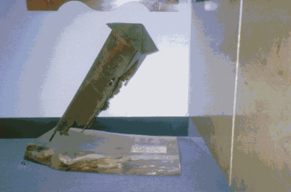
of a 115-year-old iron post. Initially, the post was refurbished for proper
display. It was mounted on a red gum plinth with a brass plaque setting out
the details described above. Figure 1 shows the refurbished post.
 Figure
1. Figure
1.
RESEARCH
All journeys begin with a first step. I contacted Peter
Knights, retired Survey Investigations Officer of the Surveyor-General’s
Office. He had written an article in a Surveying Journal in 1994 on ‘Survey
Marks and Monuments’ which included comment on Turner’s iron posts. It
stated ‘When considering the exploits of early Crown surveyors, Turner
must rank as one of the most resolute and tough’.
Peter’s advice was ‘Rightly or wrongly, a percentage
of Crown surveyors bought land in which they were involved in the survey of
– a NAME SEARCH for Tom H Turner should be made at the Land Titles Office
to see if he held land’.
This revealed that Turner had owned many Allotments in
areas he had surveyed but no definitive answers. A search was then made of
the Victorian Surveyors Board Register, a huge bound volume guarded by the
Assistant Secretary and containing the names and details of all Victorian
Surveyors since 1895. Prior to the passing of the first Surveyors Act in
1895, Surveyors were authorised to effect surveys for the Board of Lands and
Works under the regulations of the Land Act 1869.
Tom Turner was listed and the Register gave a date of his
death as 17 April 1918. A Death Certificate was then obtained which gave
much additional information. This included his age, place of birth, parents’
names, the name of his wife, his age when married, where buried and the
names and ages of his five children.
The two sons listed, Rockley Leahy and Tom Langford, were
both found to be in the Surveyors Register with a date of death for the
latter.
Next, a visit to the Springvale Cemetery and the location
of the Turner grave. Cemetery Administration was able to supply the number
and row and a walk amongst the headstones soon revealed a substantial
granite monument. It had the inscription ’In Loving Memory Tom H Turner,
Fellow of the Institute of Surveyors Victoria’, and the dates of death of
his wife, eldest son Rockley and daughter Hazel.
A search of the Newspapers of that time revealed an
Obituary in the Horsham Times dated 19 April 1918 for Tom Turner. It said he
had seen the Wimmera pass from a sheep run to its present state of
prosperity. The minute books of the Institute of Surveyors Victoria in
Melbourne from 1880 were then perused and gave much information on Turner’s
involvement and his election as a Fellow in 1918.
Now, it was known where and when Tom Turner died and some
details of his family. What remained were his early days and tracing any
descendants.
The search then went into the State archives. The
Victorian Government has documentary records since the beginning of white
settlement in the 1830’s and much of this is recorded in the Government
Gazettes. Detailed indexes are held at the Latrobe Library. Many hours were
spent in the evenings looking for references to Tom Turner and later his
brother, Edwin Woodward. Early employment of Tom H as Temporary Mining
Registrar (1872) and Wardens Clerk (1873) were found both in the absence of
Edwin Woodward. Tom H obtained his certificate of competency as a surveyor
and was authorised as a Surveyor in 1875 whilst living at Benalla. He had
trained with his brother who was also at Benalla.
Tom H Turner’s Marriage Certificate gave details of his
marriage in 1876 to Eva Leahy from Ireland. Edwin had married her sister
Josephine and their brother, Alfred Leahy, was best man at Tom’s wedding.
Leahy was the family name of well-known surveyors in Victoria’s western
district. Was there a connection? Subsequently, it was found that Alfred was
the father of the western district surveyors, Alf and Harold Leahy.
How to trace the descendants of Tom Turner? His immediate
family was gone; the next generation might still have survivors. A name
search for his sons gave a result for Tom Langford Turner. A telephone call
revealed an elderly gentleman who was the grandson of Tom H Turner but he
could not assist with information. However his son was traced and contacted.
The great grandson of Tom H Turner lived in Melbourne and was interested in
the research. He also had some family mementoes.
A visit to the great grandson provided me with a copy of
‘The Turners of Augusta’, a family history of the Turner family,
particularly that of the grandfather and father of Tom H. It included a
letter written in 1854 describing an aunt’s assistance at the birth of Tom
H himself.
The great grandson had the original theodolite and
draughting instruments of his surveyor grandfather, T Langford Turner. They
had been inherited from Tom H Turner. T Langford Turner had died in 1948 and
for many years the theodolite had been kept on a farm in a hay shed. T H
Turner's great grandson recovered it after 30 years.
The story of Tom H was largely solved. What then of the
survey across a desert and the placing of iron posts?
SURVEY RECORDS
The original Field Notes of Turner’s 1884 survey were
located in Departmental records and gave relevant dates and details of the
survey.
Information on the purpose of the survey was found from
the Nhill Historical Society and histories of the development of that part
of the State. A newspaper account of a journalist’s visit to Turner’s
survey camp in 1884 was found from Knight’s article.
The Departmental file on the survey of the Victorian –
South Australian Border was searched and gave background on Turner’s
retracement of the Border.
The iron posts were Turner’s innovation because the
desert was subject to frequent bush fires and wooden posts would have been
destroyed. He was right; the iron posts were still being located in surveys
in the 1960’s, 80 years after they were placed.
Are any of the iron posts still standing? This led to an
expedition to the Big Desert to search for remaining survey posts using
Global Positioning System technology. Was the post in the Surveyor-General’s
Office the one I ‘found’ in 1965? Yes, the Surveyor-General some years
ago after a farmer had reported it as fallen had recovered it.
FIELD INVESTIGATIONS
A colleague and myself undertook a field expedition into
the Big Desert. Equipment included a four-wheel drive vehicle, real time GPS
receiver and metal detector. Preliminary work involved checking of survey
records to determine condition of the iron posts when found, decisions on
which marks would be worth searching for and calculation of provisional
co-ordinates.
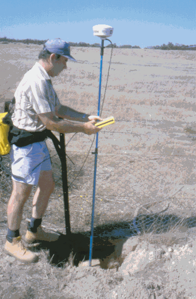
The GPS survey commenced at the starting point of
Turner's survey. It was a road intersection 15 km north of the small town of
Jeparit and a three-hour drive from Ballarat. The fences on the 142 meridian
of Longitude east and 36 parallel of Latitude south were lined out and
co-ordinates taken see Figure 2. To enable comparison with modern adjusted
values, a nearby coordinated Permanent Survey Mark was observed.
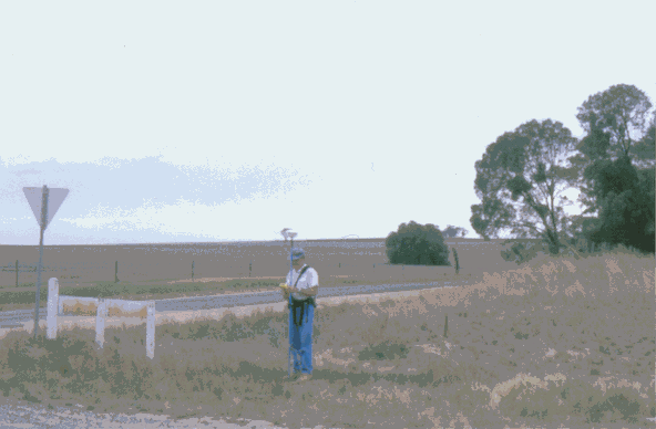 Figure
2. Figure
2.
We had a starting point for the survey. Our observed
values for the corner were 141° 59' 45" Longitude and 35° 59'
58" Latitude compared to the 1884 figures of 142° 00' 00"
Longitude and 36° 00' 00" Latitude. It must also be considered that
Turner's location was based on the then known figure of the earth, whilst
our determination was based on the 1964 Australian Geodetic Datum.
We then travelled to the west, skirting around the shores
of Lake Hindmarsh over which Surveyor Turner had carried his survey by
triangulation. A slight detour brought us up a lonely track to a grave of 'Mrs
Jardine and child' of 1847. Jardine had a sheep run on the fringes of the
Big Desert and his wife had died in childbirth. At that time, the nearest
medical assistance would have been two weeks journey away in Melbourne.
Back on the west side of the Lake we came onto the line
of the Vermin Fence and Wire Netting Road. A check co-ordinate was taken on
the corner with the Latitude as 35° 59' 58". We were on the right
line. Now came the difficult part. We carefully drove along the fence for a
distance of 3.7 kilometres to locate Post 2, at 141° 48'. Turner had
intended to place the iron posts at one tenth of a degree of Longitude
intervals but the first had fallen within deep waters of Lake Hindmarsh.
At the odometer distance we stopped the four-wheel drive
and assembled our equipment. We found that sand drift had almost covered the
original fencing and a modern fence had been erected along the top of it.
That meant, if the survey post still existed, it was fully buried. The GPS
receiver was used for an approximate co-ordinate and then the metal detector
brought into play, fine-tuned on a metal plate. Great excitement when it
started to beep loudly within half a metre of the GPS fixes. Careful
scraping away of the sand to a depth of about 15 centimetres revealed the
caved in cap of the iron post. We excavated down the sides to a depth of
about half a metre and found the post to be in good condition, 116 years
after it was placed. It was photographed, coordinated and respectfully
reburied for posterity. See Figures 3 and 4.
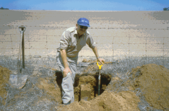 Figure
3. Figure
3.
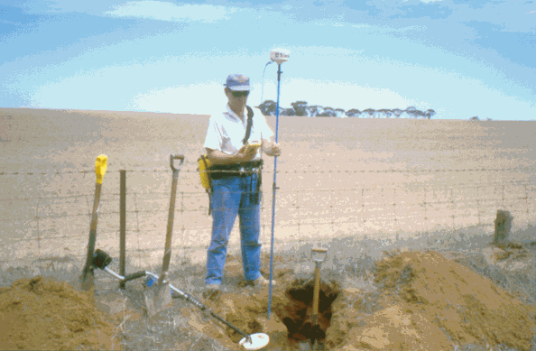 Figure
4. Figure
4.
Post 3, 9 kilometres further to the west and into real
desert was found destroyed and lying on the ground. After a unsuccessful
attempt to drive over steep sand dunes, a detour to the south and west
brought us back onto the Vermin Fence, 2.3 km west of the calculated
position of Post 4. This post was found to be still standing and in almost
mint condition, see Figure 5. The only problem was that it had two bullet
holes in the side and was occupied by a hive of bees. An extremely careful
approach from behind allowed it to be coordinated.
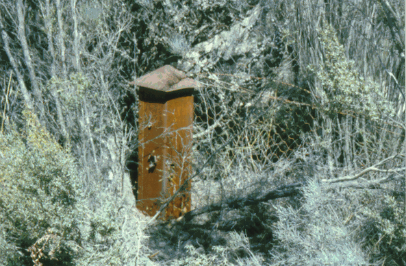
Figure 5.
The following day, the search resumed for the post at
141° 00' 00" of Longitude, 90.17 kilometres west of the starting
point. The remains of the iron post were found under a fence line in
farmland and coordinated, see Figure 6. Two further posts were then located
and coordinated, number 11 at Turner's establishment of the Victorian -
South Australian Border and number 12, 6.66 km to the north.
 Figure
6. Figure
6.
Comparisons were then made over the measured length of
the lines.
The Co-ordinates of Post 10 were observed to be 140° 59'
45" Longitude and 35° 59' 58" Latitude as against Turner's values
of 141° 00' 00" and 36° 00' 00". Effectively, this meant that
Surveyor Turner had held his Latitude and Longitude exactly, across 90
kilometres.
The measured distances of Turner's survey agreed to 1
part in 4517 between Posts 2 and 10, across 72 kilometres of steep sand
dunes.
CONCLUSION
Field investigation has established:
- Five of the 1884 iron survey posts were located, photographed and
coordinated in the course of a two-day expedition.
- The terminals of the 1884 survey were determined, enabling comparisons
with modern dimensions.
- The 1884 survey was of an extremely high level of accuracy, even by
modern standards.
- This research project has not only solved the mystery of the Turner
Survey Post but has revealed the competence of our professional
predecessors.
- Victoria is fortunate in that our original survey records remain
intact and old survey marks can still be found with modern equipment in
a very short space of time.
There is further scope for research into early surveys
and survey methods in Victoria.
It is important, looking forward into the future that we
do not overlook the past.
Properly monumented surveys are essential for the maintenance of the State's
cadastre.
Alan J Middleton
Department of Natural Resources and Environment
State Government Offices
E-mail: alan.middleton@nre.vic.gov.au
18 April 2000
|