NEW FORMS FOR GOVERNMENT LAND ADMINISTRATION - LAND VICTORIA, A CASE STUDY OF THE TREND TOWARDS COMBINING LAND ADMINISTRATION FUNCTIONS AND THE RESULTING BENEFITS TO THE COMMUNITYLeonie NEWNHAM, Adrian SPALL and Elizabeth O'KEEFFE, AustraliaKey words: government, partnership, land information, system change, international change, networks. ABSTRACTIn layperson terms, the key questions about land with which communities are concerned include: Where is it? What are its boundaries? What is on it? What can be done with it? Who owns it? Who can use it? How can it be improved? What is it worth? Government land administration functions provide answers to many of these questions in a rational and useful way. Land administration systems and procedures also provide a firm basis on which governments and individuals can undertake sound and sustainable land management. This paper explores how land administration service delivery in Victorian government has responded to the demands of the modern world, associated with increased global competitiveness, rapid advances in telecommunications, transportation and information processing. The key role these land administration institutions and associated professions had historically played in the development of Victoria meant that they saw themselves as 'keepers of the faith' and they guarded what they saw as the integrity of their operations with vigour. This meant the creation of a number of purpose-built infrastructures resulting in isolated business 'silos' where information and knowledge was jealously guarded, not easily integrated or combined, and not readily shared. Land Victoria was formed when a number of separate government entities were merged with a view to creating a coordinated land administration system and to deliver wide ranging business efficiencies and improvements to customer service. Using network theory, Land Victoria's creation can be seen to be brought about by 'the growing recognition at all levels of government that land administration and more specifically appropriate spatial business systems and associated spatial data infrastructures are essential components of any modern economy.' This paper reviews how Land Victoria as a division in a state government department was created and developed the concept of an integrated government land administration system over the last five years. 1. GOVERNMENT LAND ADMINISTRATION IN AUSTRALIAA key objective of government land administration systems throughout the world is to provide a suitable environment for the land market and a sound base for freehold and public land management. In Australia, State Governments generally do this by
Collectively, these elements provide a system that underpins each of the Australian States' land economy, including the managed development of public and freehold lands within each government's land use planning framework and the sustainable development of the environment. The land administration system in Victoria dates back to the time of European settlement. All land was claimed in the name of the Crown. An extensive land settlement and sale program occurred over the next hundred years, involving mapping, survey, valuation, alienation (sale) of Crown land and the recording of ownership and other interests in freehold land (the precursor to the Torrens title registration and guarantee system). Certain Crown land was set aside from sale through a process of reserving it for various public purposes ranging from conservation through to recreation and operational purposes. The lynchpin of Victoria's land administration system is the Torrens system of registration of interests in land which was first used in 1862 and which still operates. Land is broadly classed as freehold (in private ownership) or Crown land (unalienated and retained by the State). The latter group includes National and State parks, forests, fauna and flora reserves, and reserves set aside for public purposes. Approximately one third of Victoria's area is Crown land, representing 70,000 of the 2.4M land parcels in the State. The modern land administration paradigm is about protecting reserved Crown land, allocating rights over Crown land, regulating the freehold land market, and providing access to information and service delivery. Today, 'land administration' refers to the role of government in securing land ownership for the community, providing access to public land, protecting identified values and public open space, and establishing information systems based on where land is, what it is used for, and its value (be it in dollar terms through the freehold market or community values through public land). 2. THE CREATION OF LAND VICTORIAIn Australia, land administration is the responsibility of State and Territory Governments. Land Victoria, the agency within Victoria with primary responsibility for land administration matters, was created in 1996 bringing together of many of the State's core land administration functions into the one agency for the first time. These functions include geospatial information, mapping, survey, valuation, Crown (or unalienated) land management and freehold title creation and registration. It operates within the Department of Natural Resources and Environment's land management framework aimed at protecting identified environmental and social values of public and private land. Historically these component functions were separate departments; more recently they had been located in larger but still separate departments. The key role these institutions and associated professions had played in the development of Victoria meant that they saw themselves as 'keepers of the faith' and they guarded what they saw as the integrity of their operations with vigour. This meant the creation of a number of purpose-built infrastructures resulting in isolated business 'silos' where information and knowledge was jealously guarded, not easily integrated or combined, and not readily shared (Mooney and Grant, 1997).
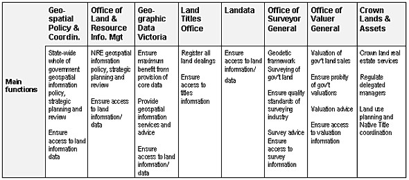
Table 1: Agencies Forming Land Victoria (December1996) The three functions which remained located outside the Department of Natural Resources and Environment are responsibility for the land use planning framework (Planning and Heritage Division, Department of Infrastructure), land as a basis of taxation (State Revenue Office, Department of Treasury and Finance), and land as the basis of rating (78 local Councils). 3. DRIVERS FOR CHANGE IN GOVERNMENT LAND ADMINISTRATIONIn the early 1990's Australia responded to global competitive pressure by reviewing its internal arrangements of government and identified ways of improving competitiveness within its economy. There was significant pressure on federal and state governments to change their method of providing services away from direct delivery towards a 'steering not rowing' approach. The trend towards smaller government focussed on introducing alternative means of direct service delivery including partnerships and arrangements with the private sector (Newnham, Parker and Spall, 2000). International drivers for change affecting Australia were the same as those operating worldwide: sustainable development, globalisation, economic reform and technological reform (Ting and Williamson, 2001). In the first instance, the changes were influenced by globalisation demands that led to microeconomic reform. This led to the adoption of a National Competition Policy introduced by the Federal Government in 1993 and adopted by the states in 1995 that further supported governments considering new delivery arrangements for services. The Victorian government also committed to the principles of competitive neutrality with the aim of ensuring that government businesses and services used full cost attribution and did not enjoy any net competitive advantage through immunity from taxes, regulations and debt charges (Williamson, Chan and Effenberg, 1998). Technological reform was another key factor as developments in information technology enabled the bringing together of activities that had been separated and disconnected by different manual or semi automated technologies. This was coupled with growing understanding by all levels of government that "land administration and more specifically appropriate spatial business systems and associated spatial data infrastructures, are essential components of any modern economy" (Ting and Williamson, 2001). A major study undertaken in 1995 by the Australian and New Zealand Land Information Council (ANZLIC), Australia's coordinating body dealing with national land information issues, identified the benefits of building a 'Land and Geographic Data Infrastructure' for Australia. This study found that for every dollar invested in producing land and geographic data in Australia, four dollars of benefit was generated in the economy. For the period 1989-94 these benefits were estimated to be in the order of A$4.5 billion, translating to roughly A$1.5 billion dollars in Victoria over a five year period. The shape of government service delivery in Victoria was dramatically altered as a result of these drivers and the related changes in government activity. Ting and Williamson (2001) have identified that the drivers had a wide impact and altered "the structure, mandate and operation" not only of government but also "private and academic sectors in Australian society". These drivers were translated in the Victorian experience of the 1990s to a government emphasis on
These influences were important in the development of Land Victoria. 4. DEVELOPING AN INTEGRATED LAND ADMINISTRATION VISION FOR VICTORIALand Victoria was created in 1996 with a clear mandate and a unique opportunity to undertake the necessary reforms to deliver wide ranging business efficiencies and improve customer service. Consequently, Land Victoria commenced a comprehensive reform program designed to lead to three major areas of benefit
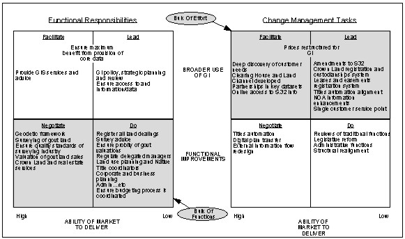
A major business review was undertaken jointly with the Boston Consulting Group to develop a common vision and mission for the organisation, identify those areas where maximum benefit could be obtained from re-engineering, and provide a model for the way forward. After a six month review, a strategic blueprint was prepared which set out the future direction of Land Victoria, outlined the extent and scope of the reform program and identified key outcomes, performance measures and timeframes. The review examined land-related processes from a customer's perspective and found that Land Victoria had "the opportunity to add significant economic value to Victoria by repositioning itself and its mission" (Boston Consulting Group, 1997). It found that Land Victoria could help 'maximise the value created from land' by leading, facilitating, negotiating or doing, depending on the ability of the market to deliver a function and the nature of the value it creates.
Figure 1: Recommended Functional and Change Management Focus for Land Victoria The required effort fell into three distinct areas:
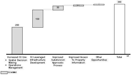
The review also found that by far the most economic value (approximately A$400 million per year) would come from a coordinated statewide improvement in the affordability, accessibility and integration of geospatial information.
Figure 2: Estimated Value to Victoria (A$m pa) Land Victoria determined that a key driver with which to achieve this reform would be through pursuing the Government's vision for electronic service delivery. As a result, Land Victoria became a key sponsor of online delivery initiatives within the State. Building on this key driver, a clearly defined organisational vision was established to point Land Victoria towards its end goal:
This vision incorporated the key elements of Land Victoria's reform program
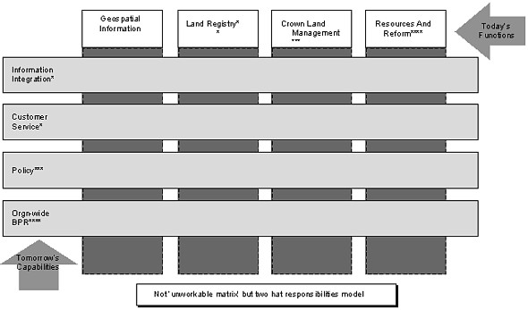
As an outcome of this review, the activities of Land Victoria were organisationally regrouped around four key areas
Figure 3: Required Shift From Functions to Capabilities After being reorganised along the above lines in July 1997, Land Victoria embarked on an ambitious and aggressive program of reform, one which continues apace today. This reform program was characterised by four key attributes:
4.1 Clear strategy and visionThe Land Victoria reform program was undertaken within the context of a clear strategy and vision that helped set the priorities for the way ahead. Land Victoria's first task was to begin to rebuild the State's land administration infrastructure to prepare it for the challenges and demands of the next century. In general terms, it was necessary to ensure that
Land Victoria's vision captured these essential outcomes and Land Victoria's overall strategy was reinforced by the subsequent development of the Victorian Geospatial Information Strategy 2000-2003 which is continuing to guide the ongoing development of Victoria's Spatial Data Infrastructure (Land Victoria 2000). This infrastructure provides the basic 'hooks' required to link fundamental land information across Victoria. The essential elements of Land Victoria's strategy and vision have remained consistent over the past five years and this has helped prioritise and focus efforts on a single goal, despite there being some variance of view within the organisation on how the goal is to be realised. 4.2 Organisational changeThe organisations that were combined to make Land Victoria had had different histories and contain different organisational cultures and perspectives. This on occasion resulted in tensions over particular business strategies, resourcing decisions and approaches. However, consistency of leadership and a continued focus on the key elements of the Land Victoria strategy have ensured that Land Victoria has remained true to its original objectives. Land Victoria has also not been afraid to take the hard decisions in moving organisational units from their traditional organisational homes in an effort to improve perspectives and service delivery outcomes. One long serving senior bureaucrat from one of the traditional 'silos' that came to make up Land Victoria advised a young colleague during the early days of reform to "just keep your head down and it will all blow over". However, the reform of 1997 was different from previous attempts in that the machinery of government changes had effectively weakened old power structures and alliances and made substantial reform of traditional organisational structures possible. The new organisational form for Land Victoria was more flexible and created a confederation of specialist activity that was the beginning of a network basis of operation (Miles and Snow, 1986; Thorelli, 1986). The organisation needed to be flexible yet enable specialisation within parts of the business. The emphasis was on relationship management across the organisation in the first instance to capitalise on the gains that could be made from coordinating activity. The new form was also more able to respond quickly and flexibly to accelerating change in technology and the needs of stakeholders. (Webster, 1992). This basic organisational form created a strong core from which the focus of activity could move outwards to other related parts of government and the private sector. Right from the outset, a focus on communication and information was adopted to ensure that staff and stakeholders remained informed as to the priorities of the organisation and the progress towards its core goals. At the same time, the professional excellence of the staff ensured that the organisation's performance was not compromised during what was to be a time of significant reform. 4.3 A new relationship management approachAlthough there were some both in and outside of the organisation who thought it would be easier to continue to apply the 'big stick' legislative approach of past State governments, Land Victoria concluded that this would not encourage joint commitment from the relevant parties. Furthermore, it was felt it would work against Land Victoria's desired intention of the construction of a single Statewide data infrastructure for Victoria across all tiers of government. Land Victoria therefore adopted a relationship management model or philosophy. This model had its roots in relationship marketing concepts of establishing, maintaining, enhancing and commercialising stakeholder and customer relationships, particularly long term relationships, so that the objectives of all the parties involved are met. (Grönroos, 1991) The key elements of relationship management as it has been applied within Land Victoria were:
With the new network organisation approach, relationship management encouraged an outward focus on building 'value-adding partnerships' (Johnston and Lawrence, 1988) and 'alliances' (Ohmae, 1989). This enabled Land Victoria to progressively include major stakeholders in the building of land information structures across the state. 4.4 Capability BuildingLand Victoria was aware that as mainstream information technology firms started to incorporate spatial technologies and applications into their core business products, a new generation of communities would begin to understand the power of integrating spatial information into their regular decision making. Not only would this lead to a rapid increase in the number of users of spatial information, it would further increase community expectations. A research and development program worth A$1.5 million over 6 years was begun with selected academic institutions to develop the next generation of information professionals and products. Major reform initiatives were undertaken in partnership with private sector firms. (This partnership is ongoing and will amount to over A$125 million dollars worth of investment over the five years to 2004.) These two initiatives have had the effect of building industry and academic capability and provide a reservoir of skilled personnel that the organisation can rely on after several years of outsourcing and downsizing during the early 1990s. In the mid 1980s, the land information industry was dominated by Government and the private sector was characterised by numerous small firms undertaking little research and development and little or no capital investment. Today, however, a growing number of firms employ upwards of 30 people, with more than 1,500 now employed in the industry as a whole, research and development is a significant part of their operations, and many are exporting their expertise overseas. There has also been a growth in the number of educational opportunities available at tertiary level. These trends are expected to continue. 5. THE LAND VICTORIA REFORM PROGRAMThe 1997 Business Review signalled significant benefits for the community if the Land Victoria program was successful (Boston, 1997). Four years on, the most recent assessment (Deloitte Touche Tohmatsu, 2001) identified benefits of up to A$220 million per annum will be available as well as a wide variety of unquantified and qualitative benefits. The nature of the benefits include cost savings, time savings, improved accuracy of land information, improved access to land information, completeness, greater transparency in property dealings, and opportunities for customer self service. Other benefits include improving Victoria's position as a place to invest, and enabling significant cost and time savings on major infrastructure projects. Land Victoria's suite of reform initiatives has been progressively developed and refined over time. Key projects within this reform program have been
These reform projects have not only improved basic land administration systems and procedures, but have also assisted in establishing a comprehensive Spatial Data Infrastructure across Victoria. The Victorian Geospatial Information Strategy 2000-2003 (Land Victoria, 2000) is designed to develop a geospatial information infrastructure and drive the value and capability of this information resource by undertaking eight strategic initiatives to support dataset development. These initiatives support geospatial information integrity by creating an overall framework, information, key business information, custody, metadata, pricing, access infrastructure, and spatial accuracy and awareness. Within the Strategy it identifies eight fundamental datasets for Victoria: Geodetic Control; Cadastral; Address 1) ; Administrative; Transportation; Elevation; Hydrology; and Imagery. The Strategy addresses industry development issues in the widest sense, covering all Governments, the private sector and academia (Jacoby, 1999). 1) The Address dataset includes geographic place and features names. The establishment of a Victorian Spatial Data Infrastructure means that the basic 'hooks' required to link fundamental land information will be in place for all land in Victoria. This will help to remove one of the major obstacles to improved land management - disjointed/difficult to integrate data. One of the key features of this spatial data infrastructure is a focus on datasets which are complete, current and accurate, with appropriate maintenance regimes in place to ensure that changes to the base information at the local level is continually reflected in Statewide datasets. (Land Victoria, 2000) Easily accessible and authoritative land information provides immense value to the economy. In Victoria, Government holds complete information about the 8 million ha of Crown land and 16 million ha of freehold land- where land is located, what its boundaries are, who owns it, what it is worth and what can be done with it. This information is fundamental to the effective operation of the A$450 billion Victorian property market. 6. PROPERTY ONLINE - A STRATEGIC FOCUS FOR ONLINE SERVICE DEVELOPMENT AND DELIVERYBy 2000, the Land Victoria reform program had developed to the stage that many of the major initiatives focusing on Victoria's basic information infrastructure were now well advanced. Land Victoria's strategy has therefore been redeveloped to focus on realising the benefits of the integrated land information and administration framework. The resultant Property Online Initiative focuses on online service development and delivery. Different Government agencies hold different information about the same piece of land, and significant benefits can be obtained when all the different information about the same piece of land is able to be linked together. The Property Online Initiative is designed to provide the practical framework that enables Government to assemble, link, integrate and deliver land information and transactions electronically to the community, business and industry. It is both a framework and a collection of projects and seeks to capitalise on the work that has been done to automate land information across various government agencies. Automation of paper based records alone will not bring the full suite of benefits that the technology enables: information needs to be organised in ways, which make it easy to find and use. Property Online also seeks to identify and drive the value-added opportunities, which become possible when the property information and core datasets are effectively in place. Linking the information held by different Government agencies about the same piece of land is vital, as is finding ways of assisting people to undertake their property and land business with government electronically. These opportunities will only be fully realised and will only fully benefit the community through developing and deepening public / private sector partnerships. Property Online concentrates on three key components that maximise the value and use of electronic media when dealing and transacting in land. These are:
Principles governing the delivery of Property Online have been clearly articulated as follows:
The Property Online program reiterates the basic strategy and vision of Land Victoria that has guided it since its formation. There are differences in emphasis that have developed over time. The increased focus on value added partnership opportunities demonstrates the success of this approach in the building of a comprehensive spatial data infrastructure for the state and highlights the need for all tiers of government and the private sector to contribute to this task. The relationship management model has had a number of successes such as the Property Information Project that worked in a long term partnership model with all 78 of the Victoria local governments to build a definitive property mapbase for the State. This was reconciled to the State's database of legal parcels and created an on-going maintenance regime. This resulted in the establishment of a common geospatial infrastructure between Local and State Government based around the State's digital cadastral mapbase. (Jacoby, 1999). In turn this project was able to built strong ties between Land Victoria and local government and helped stimulated a joint initiative between local government, Land Victoria and the Department of Infrastructure to build an e-commerce based system to manage the planning, building and subdivision applications process. The Streamlined Planning through Electronic Applications and Referrals (SPEAR) project is one of the identified Property Online Partnership projects. Similarly the Provision of property sale statements online [Vendor Statement Online], and Electronic Conveyancing Victoria (ECV) are both projects involving multiple stakeholders and involve a mix of these stakeholders working with Land Victoria in partnership. Vendor Statement Online will provide common standards and 'back-end' infrastructure through which custodians can make their property information available online and Electronic Conveyancing Victoria will enable all parties to obtain the information they need to transfer ownership in land over the Internet. 7. WHAT HAVE THESE CHANGES MEANT FOR VICTORIA?A recent evaluation of the Property Online Initiative (Deloitte Touche Tohmatsu, 2001) has identified direct benefits of A$220 million from just two of the component projects, Electronic Conveyancing Victoria and Streamlined Planning through Electronic Applications and Referrals. There are common qualitative benefits for all relevant stakeholders as follows:
Clear examples of how ready access to spatial information is an important enabler for the state's infrastructure developers can be given by reviewing major infrastructure development projects. This is shown in an evaluation of a major freeway development in Victoria's capital city Melbourne (the CityLink Project). For linear infrastructure projects, significant costs exist in the selection of sub-optimal routes and in the costs of obtaining land status information through investigation costs and lost time. The BCG study (1997) estimated the CityLink Project could have saved A$40 million if full land status information was readily available at the planning stage in the early 1990's. Other users are working with Land Victoria information as Value-Added Resellers to provide additional products based on land information. Resellers outputs have taken more traditional forms such as the creation of map based information systems for the real estate industry or the provision of online conveyancing. However they also have the potential to move into the logistics and supply industries. ANZLIC (2000) reported that the direct marketing sector is estimated to be worth about A$2 billion dollars annually in Australia, and estimated to be growing at 15-20% annually (Coombs, 2000). The boundaries of the land information market are expanding. The availability of technology allows the interchange of information and the recombination of information that enlarges community and economic interest in land information. Property Online's role in expanding activities within a wider land information market will be one of its most important long-term benefits. 8. TRENDS FOR SIMILAR DEVELOPMENTS TO LAND VICTORIA IN AUSTRALIA AND NEW ZEALANDOther states in Australia have also brought together the wider land administration functions similar to Land Victoria. In New South Wales, the key land administration functions are now split between the Department of Land and Water Conservation and the Department of Information Technology. In Queensland the Department of Natural Resources has a Land Services Business Group that deals with land information, titles, land valuation, mapping and survey and state owned land. Tasmania's Department of Primary Industries, Water and the Environment created in 1998 has similar coverage. Across the Tasman Sea the Department of Land Information New Zealand (LINZ) also was created in 1996 covering a similarly diverse range of land administration activities. It identified when it was created that advances in information technology (IT) will have a major influence on the future role of LINZ and the nature of its work (LINZ 2001) indicating that this was a key factor in its establishment. Why is there a trend towards the consolidation of land administration functions in government? This essay has explored how land administration service delivery in Victorian government is responding to the demands of the modern world, with increased global competitiveness, rapid advances in telecommunications, transportation and information processing (Webster, 1992; Ting and Williamson, 2001). The new organisational form developed for Land Victoria was that of a network (Miles and Snow, 1986; Thorelli, 1986) which enabled the organisation to build connections across the previously diverse component organisations that were joined in its formation. The network arrangement also allowed connections to be built between other organisations and assisted in building a number of value-adding partnerships (Johnston and Lawrence, 1988) and alliances (Ohmae, 1989) with a range of bodies dealing with land information. The characteristics of flexibility, specialisation, and an emphasis on relationship management embodied by the network organisational form were used by Land Victoria to respond quickly and innovatively to the accelerating changes in technology, government, and community needs. The network form of organisation can deal well with the complexity of government land information arrangements. The use of networks to build organisations has been found by Low and Abrahamson (1997) to be part of a context-dependent social change. Networks connect previously unlike or unconnected parts of the economy to form new activities similar to the activity undertaken by entrepreneurs to exploit business opportunities. The evolution of organisational form appears to be connected with the breakdown of physical or technological boundaries due to the influence of the electronic age. In part it is due to the increased sophistication of consumers at the individual and organisation level and the need for customisation to suit individual need. In complex domains involving many stakeholders in dealing with issues, network creation has been found to a key part of the successful solutions (Westley and Vrendenburg, 1997). Land Victoria's creation was seen to be brought about by 'the growing recognition at all levels of government that land administration and more specifically appropriate spatial business systems and associated spatial data infrastructures, are essential components of any modern economy.' (Ting & Williamson Survey Review 2001) The complexity of government land administration activities works within the overall context of the whole economy and Land Victoria has of necessity needed to work in partnership with other organisations to achieve its objectives for statewide reform. Property Online identifies clearly that the formal creation of networks will be needed to move to the next stage of development. With sustainable development emerging as one of the key factors in the future development of land administration systems (Ting and Williamson, 1999 and 2001; and Williamson and Ting, 2001) the complexity of the interactions between land and people will have to be catered for explicitly as part of government land administration frameworks. This is likely to see an ongoing development of more formal networks between land administration and other government administrative functions including catchment management and agriculture. There is also a growing recognition that ongoing links with the private sector must be maintained and partnerships and alliances created to support the building of shared data infrastructures. Government and private enterprise share common industry objectives in the development of a spatial information marketplace where key business principles can be established to:
9. CONCLUSIONVictoria was an early adopter of the benefits of technology in improving its land administration systems and functions. In the mid-1980s Landata was created to deliver land information electronically. However, in retrospect, the technology then available could not deliver the Government's ambitions. In addition, the organisational arrangements remained fragmented and worked against improved integration of service delivery. Land Victoria's creation and its evolution from 1996 to the present day illustrates how 'the relationship between humankind and land in almost every society is dynamic […and] varies for almost every situation' (Ting and Williamson, 1999). Other parts of Australia and its near neighbour New Zealand are now adopting this more complex form of organisation for government land administration. This indicates that network oriented organisations may be the best form of organisation to meet the demands of international drivers for change and the increasingly complex economic and societal needs for land administration systems in developed countries. While the ongoing business of an organisation like Land Victoria is not always innovative, the new form organisation must of necessity have creative and innovative ways to deal with complexity to meet objectives for system wide change. It is possible that in the future all land administration functions of government will have to develop an organisational form that allows a wide coverage across a range of land administration activities that aims to develop internally generated creativeness and innovation between previously separated parts of the land administration function. To meet needs for ongoing and system reform it is suggested that this will also have to have a focus outside traditional functions and build networks across many different sectors of the economy. The new form proposed involves the ongoing development of relationships in the form of partnership and alliances with other organisations. As Barr (1999) identifies this will of necessity include both the private and public sectors as both need to cooperate in the creation of spatial data infrastructure. The challenge for Land Victoria to 2010 is to leverage off the hard work that has already been undertaken in laying the basic foundations for improved land administration and land management in Victoria. Many of the key elements of Victoria's land administration infrastructure were laid down around 150 years ago. Over the past decade significant progress has been made in ensuring that
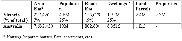
However much work is still to be done to consolidate and build on these measures. The next three years in particular will see a second wave of reforms focusing on ensuring that the community directly benefits from the substantial investment that has already been made. 10. FOOTNOTE: THE AUSTRALIAN SYSTEM OF GOVERNMENTAustralia is a federation of states and territories. There are nine jurisdictions: the federal government, six States and two Territories. Victoria is the smallest in area of the mainland States: at 227,420km2 it accounts for only 3 % of the country's area although its population of 4.8 million people makes it Australia's second most populous State (see Table 1). Australia can be classified as a developed country within the Asian Pacific region along with Japan, Korea, New Zealand and Singapore. (Williamson, 2001) Table 1: Comparison of Victoria as part of Australia according to key characteristics. (ABS 1999)
GLOSSARY
BIBLIOGRAPHYABS, 1999 Pocket Year Book of Australia. Australian Bureau of Statistics, Canberra, February 1999. ANZLIC, 2000. Anzlic discussion paper on spatial industry development, published on the web at www.anzlic.org.au/stratplan.htm. Barr, R.,1999. 'I had a dream……,' GISEurope, Issue 1, January/February 2001. Deloitte Touche Tohmatsu, 2001. Appraisal Report for Property Online, Land Victoria, NRE, Report prepared for Land Victoria. Boston Consulting Group,1997. Land Management and Resources Information Business Case. Report prepared for Land Victoria. Coombs, M.,2000. In proceedings Mapworld Conference, Sydney, February 2000. Grönroos, C., 1991. The Marketing Strategy Continuum: Towards a Marketing Concept for the 1990's, Management Decision, 29(1), pp. 7-13. Jacoby,S., 1999, Developing a Common Geospatial Infrastructure between State and Local Governments a case study from Victoria, Australia., Paper presented at the 4th International Conference on GIS in Local Government, Seoul, Korea, 16-17 September, 1999. Johnston, R., & Lawrence,P.R., 1988. Beyond verticle integration - The rise of the value-adding partnership. Harvard Business Review, 66(July-August): 94-101 Land Victoria, 2000, Victorian Geospatial Information Strategy, 2000-2003, Land Victoria, Department of Natural Resources and Environment, Melbourne, Australia. Low,M.B., & Abrahamson, E., 1997, Movements, bandwagons, and clones:Industry evolution and the entrepreneurial process. Journal of Business Venturing, 12 : 435-457. Miles,R., & Snow, J.M., 1984, Fit, Failure and the Hall of Fame. California Management Review, 26(Spring) : 10-28. Mooney, D. & Grant, D., 1997, The Australian National Spatial Data Infrastructure. In Framework for the World, ed Rhind.D. Pearson Professional Ltd, Cambridge. 187-201. Newnham, L., Parker, J., and Spall, A., 2000. Managing The Relationship Between Local Government And State Government - The Victorian Experience. Paper presented at the Conference Quo Vadis Surveying of the 21st Century as part of the FIG Working Week in Prague, May 2000. O'Keeffe, E, 1999, Local Government Consultation Strategy. Applying the Relationship Management Concept to Stakeholder Groups., Paper presented at 'From Policy to Implementation - making the Big Idea Happen;, Conference of the Institute of Public Administration Australia, Victorian Division, 28 July ,1999. Ohmae,K., 1989. The global logic of strategic alliances. Harvard
Business Review, 67(March-April): 143-54. Ting, L. and Williamson, I., 1998, Land Administration, Information Technology and Society. In Proceedings of SIRC '98: Toward the Next Decade of Spatial Information Research, (Dunedin, New Zealand: University of Otago), pp. 329-341. Ting, L. and Williamson, I.P. 1999. Cadastral Trends: A Synthesis. The Australian Surveyor, 4(1) 46-54. Ting, L. and Williamson, I.P. 2001. Land Administration and Cadastral Trends: The Impact of the Changing Humankind-Land Relationship and Major Global Drivers., Survey Review (In Press), 23 p. Thorelli, H.B., 1986, Networks: between markets and hierachies.. Strategic Management Journal, 7: 37-51. Webster, F.E., 1988, The rediscovery of the marketing concept. Business Horizons, 31 (May-June): 29-39. Webster, F.E., 1992, The changing role of marketing in the corporation. Journal of Marketing, 56 (Oct. 92): 1-17. Westley F, Vrendenburg, H., 1997, Interorganizational collaboration and the preservation of global biodiversity. Organisation Science, 31 (July-August): 381-403. Williamson, I.P. and Ting, L. 2001. Land administration and cadastral trends - a framework for re-engineering. Computers, Environment and Urban Systems (In Press), 25p. Williamson, I. P., Chan, T. O., and Effenberg, W. W. ,1998. 'Development of spatial data infrastructures - lessons learned from the Australian digital cadastral databases.' Geomatica, 52(2), 177-187. CONTACTM/s Leonie Newnham, MBA, DipEd, BA Mr Adrian Spall, MBA, BA (Hons) M/s Elizabeth O'Keeffe, LLB, 21 April 2001 This page is maintained by the FIG Office. Last revised on 15-03-16. |