THE EVOLUTION OF MODERN CADASTRESProfessor Ian P WILLIAMSON, AustraliaKey words: cadastre, land administration, evolution, land markets, humankind to land relationship, United Nations (UN), International Federation of Surveyors (FIG). AbstractToday's modern cadastres evolved from European cadastres in the 18th and 19th Centuries however it has only been in the last 20 years or so that cadastral principles have been fully recognised and adopted by the English speaking world. Due to the need to establish land markets, as well as the fall of Communism in many parts of the world, the gaining of independence of many former colonies and the need to modernise their land administration systems, most countries world wide are now undertaking some form of cadastral reform. At the same time there is a greater awareness of the important role that cadastral systems play as the central component of a land administration system in a modern economy in support of economic development, social stability and environmental management. However the role that cadastral systems play and the cadastral concept itself are continually evolving in response to the changing relationship of humankind to land and due to global drivers such as urbanisation, economic reform, globalisation, environmental sustainability and technology. In reviewing the evolution of cadastral systems, this paper considers the changing humankind to land relationship and the consequent cadastral response to that relationship. It considers the impact of land tenure on cadastres in the context of an evolving cadastral concept. The paper then discusses the dimensions and objectives of cadastres and outlines key strategies to develop modern cadastres. INTRODUCTIONToday's modern cadastres have evolved from the European cadastres of the 18th and 19th Centuries, with the French Napoleonic Cadastre and the 'Maria Theresia Cadastre' introduced by the Austro-Hungarian Monarchy having the major influence. However it was not until the last 20 years or so that the English speaking world also "discovered" cadastres and started systematically accepting and applying cadastral principles to their land administration systems. The result is that today virtually every country world wide is aware of the importance of cadastres to some degree. This world-wide understanding of cadastral principles has paralleled an increasing understanding of the role that cadastral systems play in supporting economic development, environmental management and social stability. The role of cadastres in documenting property rights and in supporting the operation of land markets has been increasingly utilised by The World Bank and other international finance and aid organisations during this period. The importance of cadastres in support of land markets gained momentum over the last two decades:
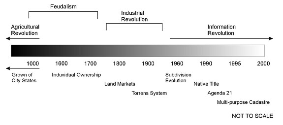
The considerable attention that land administration, and particularly the core cadastre, has received in recent times has resulted in a great deal of activity world-wide to better understand cadastral systems. There have been conferences, workshops, books, journal articles, academic courses and declarations on all aspects of cadastres (Williamson, 2000a). All this activity has improved our understanding of the cadastral concept and the role of cadastres in society. This paper provides an insight into the evolution of cadastral thinking over the last 20 years or so. THE CHANGING HUMANKIND TO LAND RELATIONSHIPThe key to understanding the evolution of modern cadastres is to recognise that cadastres, in one form or another, are an essential tool in administering the relationship between humankind and land. At the same time this relationship in almost every society is dynamic, albeit the relationship varies for almost every situation (Ting and Williamson, 1999 and Williamson and Ting, 2001). This continual change can be seen in the context of "Western" land tenure systems in Figure 1.
FIGURE 1: A Western view of the changing humankind
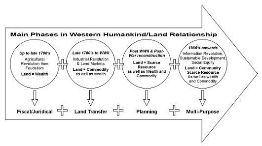
to land relationship A review of the dynamic humankind-land relationship (Ting and Williamson, 1999) shows that in a Western context, it may be classified into four broad phases as shown in Figure 2. This figure also shows the cadastral response to this changing relationship. In simple terms the cadastral response in feudal times was primarily fiscal. A legal requirement was added to accommodate the growth of land markets and then a planning requirement was added as private land became scarce after World War II. Today land is seen as a scarce community resource with environmental and social considerations tempering the historic economic driver. As a result, cadastres are assuming a more multi-purpose role with the multi-purpose cadastre vision of the mid-1970s (NRC, 1983) starting to become a reality. As a result of the increasing interest in cadastral systems, a number of statements, guidelines and declarations have been developed which assist in explaining the cadastral concept and which highlight its evolving nature (discussed later).
FIGURE 2: The cadastral response to the changing
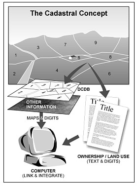
humankind to land relationships THE IMPACT OF THE EVOLUTION OF LAND TENURESA shown in Figure 3, the traditional view of a cadastre is the recording of information about each individual parcel. Many cadastral systems emphasise the recording of "simple" private ownership rights with many systems still not recording public rights in the title register However a cadastral system can record a wide range of complex rights, restrictions and responsibilities in land (UN-FIG, 1996). They can record partial rights and multiple rights. However it is only in the last 20-30 years that cadastral systems started to become more sophisticated in accommodating a wider variety of rights. A useful introduction to land tenure in developing countries is found in the book titled "Land Tenure in Development Cooperation - Guiding Principles" produced by GTZ (1998). For example the need to record strata or condominium rights (apartments) and associated common property in the cadastre is a relatively recent development in most western countries. Interestingly these new tenure relationships have much in common with the rights in a traditional African village compared with classic individual private rights in the Western sense. For example Strata Titles and Community Titles legislation in Australia uses approximate boundaries for individual parcels, individual owners have shares in the common property, and the individual owners comprise a Body Corporate and elect a Chairperson ("Chief") to manage the whole "village" and particularly the common property. If for example an owner wishes to grow some vegetables on the Common Property, the Body Corporate (or "Chief") can allocate some land and the person can grow the vegetables and own the results of their endeavors. When they have finished with the land it automatically returns to the Body Corporate. It is not uncommon for 50% or more of the population of a European country to live in apartments in this manner (although many rent, not own their apartment). There are many variations on this theme in western countries which are usually not highlighted in the cadastral literature. For example almost every modern Western country has "trailer parks" on the outskirts of their major cities. The trailers are usually owned by the occupiers however they do not own the land although many pay local taxes. They do however have some form of tenure with the result it is difficult for them to be evicted in most countries without due process. These trailer parks could be considered the "slums" of the developed world since there are many analogies with the developing world. This analogy is important to encourage flexibility in recording rights in land. This is particularly the case in the documentation of informal, illegal, slum or squatter settlements in developing countries. This flexibility is also important when recording indigenous rights in the cadastre. In many cases indigenous peoples do not share the same cartographic knowledge as their western counterparts and as such different approaches are required when recording their rights, restrictions and responsibilities (including the difficult consideration of their sacred sites). The reality is that in all countries there is a range of tenures that can and should be recorded in a cadastre, if and where appropriate. If the fundamental needs resulting from of the relationship of humankind to land are addressed (primarily access to land and security of tenure) in the cadastre as a first priority, a more flexible approach to recording boundaries is also easily accepted. For example the use of Qualified titles and boundaries "limited as to survey" are useful low cost approaches for establishing a cadastre. In many cases a property can simply be identified by its street address (without survey) on a very approximate index plan as long as its boundaries are well defined by occupations. The Malaysian system is an excellent example of the use of Qualified Titles which are issued for all intents and purposes without survey. THE EVOLVING CADASTRAL CONCEPTWhile there has been a considerable amount of documentation on or reference to cadastres for much of the 20th Century, especially in Europe, there continues to be considerable debate as to what constitutes a "cadastre". To some degree what constitutes a "cadastre" is in the eyes of the beholder. To attempt to clarify the concept the International Federation of Surveyors established a working group in 1992 to develop a "Statement on the Cadastre" (FIG, 1995). The statement defined a cadastre as "…a parcel based and up-to-date land information system containing a record of interests in land (e.g. rights, restrictions and responsibilities). It usually includes a geometric description of land parcels linked to other records describing the nature of the interests, and ownership or control of those interests, and often the value of the parcel and its improvements." The FIG cadastral concept is shown diagrammatically in Figure 3.
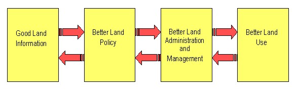
FIGURE 3: Cadastral Concept (FIG, 1995) While the FIG Statement on the Cadastre was important, it did not fully recognise the role that cadastres play in the operation of land markets. As a result, the United Nations with the support of the FIG developed the "Bogor Declaration on Cadastral Reform" (UN-FIG, 1996). The Bogor Declaration proposed the development of "… modern cadastral infrastructures that facilitate efficient land and property markets, protect the land rights of all, and support long term sustainable development and land management". It also established principles for re-engineering cadastral systems. Importantly the Declaration stated that a cadastral infrastructure "… can support a vast array of legal, technical, administrative and institutional options in designing and establishing an appropriate cadastral system, providing a continuum of forms of cadastre ranging from the very simple to the very sophisticated. Such flexibility allows cadastres to record a continuum of land tenure arrangements from private and individual land rights through to communal land rights, as well as having the ability to accommodate traditional or customary land rights." Further it stated that "…The success of a cadastral system is not dependent on its legal or technical sophistication, but whether it protects land rights adequately and permits those rights to be traded (where appropriate) efficiently, simply, quickly, securely and at low cost. However if the resources are not available to keep the cadastral system up-to-date then there is little justification for its establishment." (UN-FIG, 1996) As mentioned the English speaking world did not fully embrace the cadastral concept until the late 1970s or early 1980s (McLaughlin 1975; NRC, 1983; Williamson, 1983; Dale and McLaughlin, 1986). However many of the basic principles were adopted much earlier, especially cadastral surveying principles (Dale, 1976; Binns and Dale, 1995; Dowson and Sheppard, 1953). The 1990s has seen many more books, articles and conferences concerned with cadastral systems and cadastral reform, such as the Cadastral Reform Conferences at the University of Melbourne in 1990 and 1992 (also see Larsson, 1991; Dale and McLaughlin, 1999). With the collapse of the Communist regimes in Eastern and Central Europe, the United Nations Economic Commission for Europe (UNECE) recognised the need for guidelines to assist countries to establish cadastral systems in support of land markets. The UNECE established a Meeting of Officials of Land Administration (MOLA) to develop the Land Administration Guidelines (UNECE, 1996). Due to the importance of land administration in supporting market economies, MOLA has now been upgraded to the Working Party on Land Administration (WPLA). As a result of the continuing debate as to what constitutes a "cadastre", particularly in Europe, the UNECE adopted the term "land administration" instead of "cadastre". MOLA defined land administration as "the process of determining, recording and disseminating information about the tenure, value and use of land when implementing land management policies" (UNECE, 1996). In this context land administration is considered to include land registration, cadastral surveying and mapping, fiscal, legal and multi-purpose cadastres and parcel based land information systems, and in many systems, information supporting land use planning and valuation/land taxation systems. For the purposes of this paper the term "cadastre" will be used to describe the core land administration functions of land registration, cadastral mapping, a computerised parcel based information system together with the information and communication technologies associated with maintaining and accessing the cadastre. At the same time, the FIG continues to investigate cadastral issues in its Commission 7 (Cadastre and Land Management) (see www.fig.net). In 1994 the Commission established a Working Group to describe a future cadastre in 20 years (Cadastre 2014) (Kaufmann and Steudler, 1998). Cadastre 2014 recognises the changing relationship of humankind to land, the changing role of governments in society, the impact of technology on cadastral reform, the changing role of surveyors in society and the growing role of the private sector in the operation of the cadastre. Importantly Cadastre 2014 emphasises the importance of cadastres being complete and including all public as well as private rights in the cadastre. Cadastral reform and associated land titling and land administration projects today still emphasise the key role of documenting individual private rights in support of land markets. However there is a growing recognition in many countries, in organisations such as the United Nations and The World Bank, and with land administration practitioners, that land administration, and particularly the core cadastral system, has an equally important role in supporting sustainable development objectives, rather than the traditionally narrow focus on land markets (Wiebe and Meinzen-Dick, 1998). This resulted in the development of the joint United Nations-FIG Bathurst Declaration on Land Administration for Sustainable Development (UN-FIG, 1999; Williamson et al, 2000). The Bathurst Declaration concluded that "most land administration systems today are not adequate to cope with the increasingly complex range of rights, restrictions and responsibilities in relation to land, which are influenced by such factors as water, indigenous land use, noise and pollution". In short, land information and land administration systems need to be re-engineered and to evolve to face the increasing complexity of the humankind-land relationship. They will need to play a fundamental role in facilitating and supporting the complex decision making that is integral to sustainable development as shown in Figure 4. In short sustainable development is just rhetoric without appropriate land administration systems. (UN-FIG, 1999)
FIGURE 4: Land administration paradigm (UN-FIG, 1999) Another useful article exploring this evolution is by Enemark (2000). THE DIMENSIONS OF CADASTREIn designing a cadastral reform strategy it is first important to recognise that almost every country will require a range of different strategies depending on the relationship of humankind to land in each individual region in the specific country. In simple terms these arrangements include:
To some degree these categories are common to all developing (and many developed) countries. The second consideration is that the relationship of humankind to land is dynamic with the result that there is an evolution in the each of these categories. None of these relationships stay the same in the long term. They are affected by the impact of the global drivers on the relationship of humankind to land such as sustainable development, urbanisation, globalisation, localisation, economic reform and environmental management. As a result a different land administration response is required for each area or situation, within an overall national vision or strategy. The categories of land tenure can be considered a continuum of land tenure relationships in a country where to some degree tenures evolve from undocumented customary or informal tenures to documented or formal individual private rights. Third, the stage of development of the specific country has a major influence on the appropriate form of land administration response, and what is considered "best practice" for the individual country. As an example, in simple terms in the Asian-Pacific area there are four general categories of countries:
While each country has different development priorities, those in each group do share some similar priorities. A complication is that many countries do not fit easily into these categories with some countries having aspects of all categories. But in general the stage of development overall of an individual country does significantly influence the choice of which land administration strategies are adopted. The combination of all these factors determine or at least strongly influence the specific strategy or strategies adopted in reforming or establishing the land administration system. These strategies draw on the land administration "tool box" for their institutional, legal, technical and administrative solutions. For example there is a whole range of surveying and mapping technologies and approaches depending on what is the stage of development of the country and what is the major relationship of humankind to land which is being surveyed or mapped. These options include sporadic and systematic approaches, graphical and mathematical surveys, different positioning technologies such as satellite positioning or scaling off photomaps, different mapping technologies such as satellite images, photomaps, topographic mapping and simple cadastral maps. In addition there is a range of options for recording land tenure relationships. There are government guaranteed land titles, deeds registration systems, title insurance systems, qualified titles (both to boundaries and title), individual ownership and communal or customary ownership. For all these arrangements there are a range of technologies which are again strongly influenced by the wealth and development of the country. For example whether titles or deeds and cadastral maps will be computerised or held as paper records or whether the Internet or even wireless technologies can be utilised to access land records. Institutional arrangements are influenced by the same factors; whether the system is decentralised, deconcentrated or centralised; or based on the level of education and training in a country. For example if a country such as Indonesia wished to have a land administration system supported by a land title and cadastral surveying system similar to Australia, this could possibly require 40,000 professional land surveyors and 30 or more university programs educating professional surveyors (based on Steudler et al,1997). Clearly this is not realistic in the short to medium term and as a result this re-enforces the need to develop appropriate solutions matched to the stage of development and specific requirements of the individual country. The cadastral options can be considered under the following headings (Williamson, 2000a):
THE OBJECTIVE OF CADASTRESOver the last 20-30 years the development of new or improved cadastral systems have had a focus on the adjudication of individual private rights, primarily in support of the establishment of a land market (Deininger and Binswanger, 1999; de Soto, 1989 and 1999). This focus is too narrow. Over the last decade there has been an increasing focus on the documentation of public rights as well (including in forests), specifically to meet environmental sustainability objectives (Wiebe and Meinzen-Dick, 1998). At the same time there is also a growing body of knowledge on the social benefits of providing access to land and security of tenure (UNCHS, 2000). The broadening role of cadastres can be seen in the objectives of the current Greek National Cadastral Project (USD2+ billion over about 20 years) (Grant and Williamson, 2001) and the objectives for establishing cadastres in Central European Countries in support of accession to the EU (Bogaerts and Williamson, 2001). In the case of the Greek cadastre the primary objectives are:
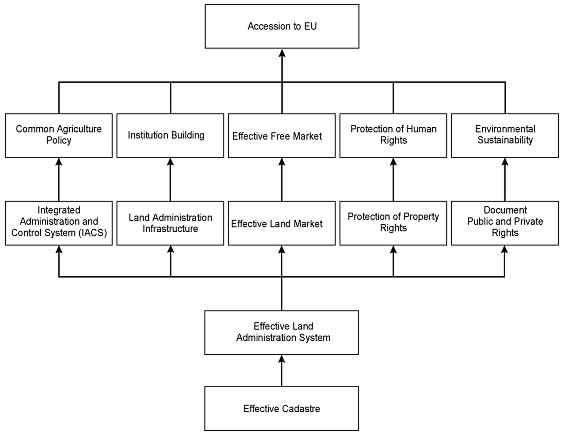
Figure 5 shows a framework explaining the role cadastres play in the accession of Central European Countries to the European Union. Importantly the framework links the establishment and maintenance of a Common Agricultural Policy, institution building, the establishment of a free market, the protection of human rights and the support of environmental sustainability to the cadastre.
FIGURE 5: Framework showing the role of a cadastre in the accession of Central European Countries to the European Union (Bogaerts and Williamson, 2001) KEY CADASTRAL REFORM STRATEGIESThere are many books and articles written about cadastral and land administration "best practice" (refer to the references for examples), however a number of key cadastral reform issues or strategies stand out in recent years based on the author's experience, as discussed below.
CONCLUSIONThe key to the success of establishing modern cadastres is to remember that they are continually evolving in response to the changing humankind to land relationship, that they must be driven by the needs of users and that they "… are not ends in themselves. They support effective land markets, increased agricultural productivity, sustainable economic development, environmental management, political stability and social justice." (UN-FIG, 1996) ACKNOWLEDGEMENTI am grateful for the support of the University of Melbourne, the Delft Technical University of Technology and the Spatial Data Infrastructure and Cadastral Research Group at the University of Melbourne in the preparation of the article. (www.geom.unimelb.edu.au/research/SDI_research/) REFERENCESBogaerts, T. and Williamson, I.P. 2001. The role of land administration in the accession of Central European countries to the European Union. Submitted to the Journal of Land Use Policy, 29p. Binns, Sir Bernard O. and Dale P.F. 1995. Cadastral surveys and records of rights in land. Based on the 1953 study by Sir Bernard O. Binns, revised by Peter F. Dale. FAO Land Tenure Studies 1, UNFAO Rome. http://www.fao.org/icatalog/book_review/giii/land1-e.htm (accessed 7 August, 2000). Dale, P.F. 1976. Cadastral Surveys within the Commonwealth. HMSO Dale, P.F. and McLaughlin, J.D., 1986. Land Information Management. Dale, P.F. and McLaughlin, J.D., 1999. Land Administration. Oxford University Press. De Soto, Hernando, 1989. The Other Path: the invisible revolution in the Third World. Harper and Row, New York. De Soto, Hernando, 1999. The Mystery of Capital. Basic Books, New York. Deininger, K. and H. Binswanger, 1999. The evolution of the World Bank's Land Policy: Principles, Experience, and Future Challenges. The World Bank Research Observer 14(2) (August, 1999), 247-76. Dowson, E. and V.L.O. Sheppard 1956. Land Registration. HMSO, London. Enemark, S. 2000. Ejendomregistrering og arealforvaltning i et globalt perspektiv (Land Registration and Land Management in a Global Perspective) in Sorensen, Esben Munk (ed): Ejendomsendringer i det tyvende aarhundrede (Property Development in the 20th Century), The Danish Association of Chartered Surveyors, Copenhagen, 365-385. FIG, 1995. Statement on the Cadastre. Report prepared for the International Federation of Surveyors by Commission 7 (Cadastre and Land Management). http://www.fig7.org.uk/ Accessed 15 August, 2000. Grant, D.M. and Williamson, I.P. 2001. Hellenic Cadastre - genesis and development. Paper presented to CONSAS 2001, Cape Town, South Africa, 12-14 March, 2001, 20p. GTZ, 1998. Land Tenure in Development Cooperation - Guiding Principles. Gesellschaft fur Technische Zusammenarbeit (GTZ) GmbH, Eschborn. Published by Universum Verlagsanstalt, GmbH, KG, Wiesbaden, Germany. Also see http://www.gtz.de/. Kaufmann, J. and Steudler, D. (1998) Cadastre 2014: A Vision for a Future Cadastral System (Rheinfall, Switzerland: FIG). http://www.swisstopo.ch/fig-wg71/ Accessed 5th September, 1999. Larsson, G. 1991. Land Registration and Cadastral Systems. New
York: Longman Scientific and Technical. NRC, 1983, Procedures and Standards for a Multipurpose Cadastre. Panel on a Multipurpose Cadastre, National Research Council, Washington D.C, National Academy Press. Steudler, D., Williamson, I.P., Kaufmann, J. and Grant, D.M. 1997. Benchmarking Cadastral Systems. The Australian Surveyor. 42(3) 87-106. Accessed 17 August, 2000 http://www.sli.unimelb.edu.au/research/publications/IPW_publ.html Ting, L. and Williamson, I.P. 1999. Cadastral Trends: A Synthesis.
The Australian Surveyor, 4(1) 46-54. UNECE,1996. Land Administration Guidelines. Meeting of Officials on Land Administration, UN Economic Commission for Europe. ECE/HBP/96 Sales No. E.96.II.E.7, ISBN 92-1-116644-6. WWW accessed 5th September, 1999 http://www.sigov.si/mola/Preview/html/projects.html#nas1. MOLA has been upgraded to Working Party status as the UNECE Working Party on Land Administration (WPLA) at http://www.unece.org/env/hs/wpla/welcome.html UN-FIG, 1996. Bogor Declaration on Cadastral Reform. Report from United Nations Interregional Meeting of Experts on the Cadastre, Bogor, Indonesia, 18-22 March, 1996. A joint initiative of the International Federation of Surveyors (FIG) and the United Nations. http://www.sli.unimelb.edu.au/research/publications/IPW_publ.html UN-FIG, 1999. The Bathurst Declaration on Land Administration for Sustainable Development. A joint initiative of the United Nations and the International Federation of Surveyors. http://www.sli.unimelb.edu.au/UNConf99/ Also see at this WWW address the Findings of the Workshop and the background papers prepared for the Workshop and presented at the subsequent International Conference on Land Tenure and Cadastral Infrastructures for Sustainable Development, 25-27 October, 1999 Melbourne. Wiebe, K.D. and R. Meinzen-Dick, 1998. Property rights as policy tools for sustainable development. Land Use Policy, 15(3), 203-215. Williamson, I. P., Chan, T. O., and Effenberg, W. W. (1998) Development of spatial data infrastructures - lessons learned from the Australian digital cadastral databases. Geomatica, 52(2), 177-187. Williamson, I.P. and Ting, L. 2001. Land administration and cadastral trends - a framework for re-engineering. Computers, Environment and Urban Systems (In Press), 25p. Williamson, I.P., Ting, L. and Grant, D.M. (2000). The Evolving Role of Land Administration in Support of Sustainable Development - A review of the United Nations - International Federation of Surveyors Bathurst Declaration for Sustainable Development. The Australian Surveyor 44(2) 126-135. Williamson, I.P. 2000a. Land Administration "Best Practice" - providing the infrastructure for land policy implementation. Submitted to Journal of Land Use Policy, 19p. CONTACTProf. Ian Williamson 14 April 2001 This page is maintained by the FIG Office. Last revised on 15-03-16. |