A number of attractive and informative Technical Tours have been organised to complement the conference experience. All tours start at Horncastle Arena, main entrance and drop offs (except GIS tour) are at CBD Hotels then Horncastle Arena. Tickets may be available for purchase from the Registration Desk.
The technical tours at a glance - click on the tour for more
information:
Tuesday
|
TT1A - Christchurch Rebuild Fee: 35 EUR - 60 NZD Departure: 13.00 |
TT2 - Port Hills Tours
Fee: 20 EUR - 35 NZD Departure: 13.00 |
TT3 - GIS Tour - 3 May
Fee: 20 EUR - 35 NZD Departure: 13:10 (return to Horncastle Arena at 16:00) |
Wednesday
|
TT1B - Christchurch Rebuild
Fee: 35 EUR - 60 NZD Departure: 13.00 |
TT4 - The Arts Centre
Fee: 20 EUR - 35 NZD Departure: 13.30 |
TT5 - University of Canterbury
Fee: 20 EUR - 35 NZD departure: 14.00 |
Thursday
|
TT1C - Christchurch Rebuild
Fee: 35 EUR - 60 NZD Departure: 13.00 |
TT6 - Land Information New Zealand tour
Fee: 20 EUR - 35 NZD Departure: 13.00 |
TT7 - Preston Rebuilding Tour Fee: 20 EUR - 35 NZD Departure: 13.30 |
Meeting point: Horncastle Arena, main entrance
Please note, all tours have a limited number of seats available. All tours are based on a minimum number of participants. If this number is not reached, alternative places will be allocated strictly in order of receipt of bookings. Where participants cancel their tour bookings prior to 2 February 2016, payment will be refunded in full. Thereafter, no refund will be made.
Christchurch Rebuild Tour
The Christchurch Rebuild Tour offers a unique guided experience by
bus around the ever-changing post-earthquake Christchurch City Centre
and a visit to the Quake City attraction.
The informative bus tour takes visitors on a journey through the
Christchurch rebuild: what was, what’s happening now and what’s coming.
It provides an insight into the innovative ways that Christchurch is
reshaping itself following the earthquakes of 2010 and 2011.
The tour includes a professional presentation from a Canterbury Museum
guide and an on-board display of photo images, concept plans and artists
impressions.
Features:
Quake City
Quake City is a unique multi-sensory attraction aimed at educating
people about the Canterbury earthquakes.
During this self-guided walk around the attraction you will be able to:
|
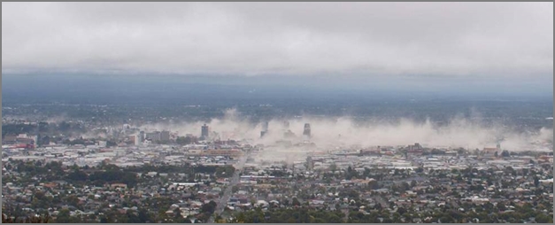
22 February 2011: Christchurch was struck by a magnitude 6.3 aftershock. Its epicentre was just 10km south east of the city, and it was only 5km deep. The shaking intensity was much greater than the main September 2010 earthquake due to the proximity to the city, and the shallow depth. This shaking caused widespread liquefaction on the flat, and land slippage and rock falls in the Port Hills. |
 |
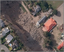 |
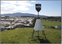
The Port Hills rock falls resulted in one of the largest rock fall studies in the world. To determine the ongoing extent of land movement multiple continually operating CGPS stations and crack monitoring points were installed. Monitoring moved quickly from a basic string line between 2 points, to state-of-the-art survey monitoring. Selected areas on the Port Hills featured land damage that posed a significant risk to people’s lives, and it was decided this land would not be rebuilt on. |
|
The land has been zoned ‘red’ and a purchase offer to affected property owners made by the Crown. |
|
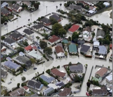 |
Liquefaction and lateral spreading caused widespread damage on the flat, and significantly damaged buildings. Detailed geotechnical investigations and analysis showed that for over 8,000 properties the land underneath them was not able to be rebuilt on. This land was also ‘red zoned’ and a purchase offer was made to the property owners by the Crown. |
|
The tour will take you through the red zoned land on the Flats and Port Hills. It will also cover the surveying and geotechnical engineering work to support the zoning decisions and showcase some of the active survey stations including CGPS, remotely operated robotic survey stations and terrestrial surveys. |
|
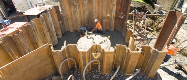
Stronger Christchurch Infrastructure Rebuild Team (SCIRT) was formed
following the earthquakes, to rebuild Christchurch’s horizontal
infrastructure including wastewater, stormwater and potable water,
roads, bridges and retaining walls.
SCIRT has a 5 year lifespan, programmed to finish in December 2016, and
a budget of over NZ$2 billion to performs condition assessment, scoping,
design and construction to achieve it core value of “creating resilient
infrastructure that gives people security and confidence in the future
of Christchurch”
Location data has been a core part of SCIRT and its use has grown in
every discipline. In designing the system, there has been intentional
consideration of future technologies that will change the way location
data is used by everyone. SCIRT has developed a GIS viewer that contains
over 600 spatial layers providing a comprehensive picture of nearly all
aspects affecting the repair of the horizontal infrastructure. In doing
so, the SCIRT GIS system has been recognised both locally and
internationally as providing significant value to the rebuild.
SCIRT has also undertaken a large survey programme that surveyed the
majority of wastewater and stormwater assets prior to designing the
repair. It also undertakes survey of new assets constructed or repaired
under the programme. In doing so, a comprehensive, accurate
dataset of new and existing assets has been created.
The tour will look at data that initially existed and the systems and
data we have created. Come and learn how it was done; what worked, what did
not, and what we would change if we had our time again, and what we
think the future holds.
Fineen McCarthy and Charlie Dickson
(New Zealand)
“Creating resilient infrastructure that give people security and
confidence in the Future of Christchurch”
[Presentation]
[Voice
over]
Todd Davis and Emma Winthrop (New
Zealand)
SCIRT GIS - When collaboration, integration and the future of our city
matter
[Presentation]
|
This is a combined tour through two of Christchurch’s most iconic and treasured attractions.
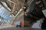
The Arts Centre of Christchurch
The Arts Centre is one of the most significant clusters of heritage buildings in New Zealand. Once the site of the University of Canterbury, these distinctive Gothic Revival buildings have been transformed into an internationally renowned centre for the arts, culture and creativity.
As a result of the 2010 and 2011 Canterbury earthquakes, all but one of its 23 heritage buildings sustained significant damage and a $290 million restoration programme is now well underway.
As well as retaining the Arts Centre’s unique architectural and historical importance, the restoration aims to create a hub of creative entrepreneurs in the heart of Christchurch that is undeniably 21st Century: capacity building, content-rich and digitally enabled.
The Arts Centre part of the tour will include presentations on its heritage and architecture, the restoration work and a guided site tour. During the site tour, you will get the chance to see first hand how surveying has contributed to the restoration, preservation and maintenance of the buildings’ heritage fabric.
Christchurch Art Gallery Te Puna o Waiwhetu
Christchurch Art Gallery Te Puna o Waiwhetu is an important part of the cultural life of Christchurch city and within New Zealand’s network of galleries and museums. With over 6,500 works of art, its collection is significant and varied.
The Art Gallery offers a variety of exhibitions and other programmes, with its own collection at the core of what is shown, but augmented by works of art and exhibitions from other collections around the country and internationally.
During the National Emergency declared after the Canterbury earthquakes, the building became the Emergency Operating Centre and hub for the recovery, housing hundreds of workers. The Gallery stood strong during the earthquakes and remained a safe place to work, but it did sustain damage due to the subsidence of the land underneath. After five years of repair the Art Gallery re-opened in December 2015 to over 10,000 visitors in it's opening weekend.
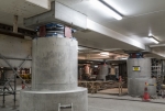
The Art Gallery part of the tour will include presentations on its art collections and current exhibitions as well as the repair and strengthening works (including re-levelling) and a guided tour of the base isolation in the basement.
Requirements: Please wear flat, sturdy footwear. No high heels or sandles. Hard hats and safety vests will be provided.
The major focus within the Canterbury region over the next fifteen
years will be the rebuilding of Christchurch. The University of
Canterbury is committed to being an integral part of the rebuilding
process providing high quality research to underpin the recovery effort.
Earthquake research is being conducted in almost every department within
the University, from Engineering to Social and Political Sciences.
Overall there are 200 projects, many of which are directly contributing
to the recovery of Canterbury.
Canterbury Earthquake Sequence
A presentation describing the Canterbury Earthquake Sequence, its effects on the city of Christchurch and surrounding region, what has been learnt from the earthquake and what other earthquake-related hazards lay ahead for Canterbury and beyond.
Future of Earthquake Engineering
The $40 billion cost of damage from the Christchurch earthquakes
cannot be tolerated when the next major earthquake strikes another New
Zealand city such as Wellington.
Previous UC engineering research saved thousands of lives worldwide, so
the next big challenge is to extend the world-class research to
drastically reduce the cost of damage to the built environment, and
costs of repairs, in future events.
This presentation will provide an overview of some of the engineering
research being carried out to counteract seismic risk by developing
resourceful, innovative and world-class engineering solutions.
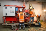
Structural Engineering Labs
A guided walk through the Structural Engineering Laboratories to see examples of this world class research in action. The tour will include the brand new Structural Engineering Building currently under construction.
|
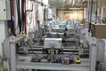
Land Information New Zealand makes sure New Zealand has accurate information about where people and places are, and so that people have confidence in their property rights and Crown property is well managed for future generations. |
|
|
Their responsibilities include managing land titles, geodetic and cadastral survey systems, topographic information, hydrographic information, managing Crown property and supporting government decision making around foreign ownership. LINZ administers the online survey and title system Landonline. New Zealand was the first jurisdiction in the world to develop an integrated electronic titles register and cadastre enabling people to search property ownership and boundary records online, in one place. LINZ also make over 40 groupings of data on New Zealand’s land and sea available for free through their online LINZ Data Service - LDS. The LDS includes topographic data used to create maps and hydrographic information used to create marine charts. It includes information about property, from place names and addresses to boundaries and land ownership. It includes information on Crown pastoral land leases, and includes aerial images which provide an accurate photographic picture of the land’s surface. |
  |
|
This tour will offer a unique opportunity visit the Land Information New Zealand Christchurch office where survey and title transactions are processed. Come along and learn more about Landonline system including a working demonstration of the lodgement and processing of a survey transaction. The tour will also include an overview of the LINZ Data Service, and a presentation on the Geodetic response to the Canterbury earthquakes. |
|
|
Phil Davison (New Zealand) |
 |
|
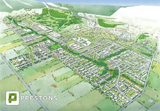
As a consequence of the Canterbury Earthquake sequence,
thousands of families were displaced from their homes due to
land damage. New housing was urgently needed to house some of
those families. The go-ahead for the Prestons subdivision was
passed under emergency legislation, bypassing to a large extent
the typical planning processes and involved a unique set of
engineering challenges. Today Prestons is a dynamic new thriving residential subdivision in the north east of Christchurch, approximately 20 minutes’ drive from the city centre. |
 |
 |
The development, designed to be a sustainable urban village, is
203-hectares in size and will become a residential precinct for
over 2,300 houses and 8,000 residents. Considerable ground engineering work has taken place to mitigate the effects of liquefaction and lateral spreading in future seismic events. This work included importing a large high energy impact compactor (HEIC) which was used to densify 60 hectares of land, enabling standard house foundations across the subdivision. |
|
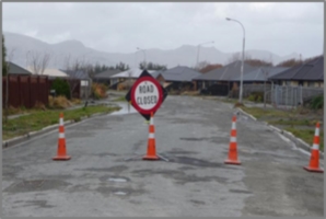
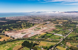
Due to the large site and flat terrain Prestons as the first
large vacuum wastewater system in a residential subdivision in
New Zealand. Not only is this the most cost effective solution
for the developer and Council, it is the best solution for
seismic resilience. Before and after visiting the Prestons subdivision, the tour will take you through some of the most badly damaged residential areas to the east of Christchurch. This highlights the large scale of the residential demolition process, the difficulties dealing with/managing the damaged land and what the future might look like for these now deserted lands |
|