|
|
|
|
|
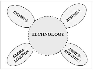
5th GSDI (Global Spatial Data Infrastructure) Conference In a few years no one will think of spatial data as something special. Spatial data will be integrated in all kinds of information systems. Sometimes they will be visible. In other cases they will be invisible, but indispensable because they are the underlying basis in the different information systems. Data from different sources and data with different accuracies will be used in new combinations. National and regional users, as well public as private, will demand nationwide homogeneous data sets. In time with integration of spatial information in the information systems, there will be a strong need for people who can manage the technical and organisational aspects of combining data and in turning raw data into understandable information. People skilled in management of spatial information. Within FIG Commission 3 is responsible for Spatial Information Management and related topics. SPATIAL INFORMATION AND SUSTAINABLE DEVELOPMENTAgenda 21 and The Habitat II Global Plan of Action address the need for information, development of appropriate databases and exchange of information as conditions for creating the basis for sustainable development in all regions of the world. One reason for this is that the global society faces great problems concerning urbanisation and the influence of urbanisation on coastal zones and environmental conditions overall. It is generally accepted that Spatial Information is an indispensable part of the basic infrastructure in the individual country. Again and again it is stated that spatial information affects 80% of human decisions making. Regardless of the stage of development, there are innumerable applications for spatial information. The following are some examples of major, but also very different, areas of application: cadastre projects, land management, transportation infrastructure, health monitoring programmes, socio-economic issues, monitoring of environmental issues, environmental impact assessment, conservation projects, and natural resource management. Because the users have very different backgrounds, there will be a need for comprehensible instructions on the possibilities and limitations of data from the individual data collections and there is a need for user-friendly, efficient distribution systems. /1/ DEVELOPING TRENDSThe accelerating technological development offers the users possibilities for access to information and services that was unforeseeable a few years ago, and this is a continuing process /2/, /3/. High costs are involved in the establishment and maintenance of the necessary spatial data. Therefore, many people are endeavouring to utilise alternative methods for collecting data and to use other data types. The new technologies will give us new methods for data capture in digital form. Remote sensing will give us cheaper data. Real time positioning will revolutionise the traditional fieldwork, etc. The available data will be used as well in public and private administration as in business. Networks of permanent stations supporting real time and post processed GPS surveying will be increasingly important parts of the Spatial Data Infrastructure. Personal navigation is another hot issue. By means of a mobile phone or a minimized GPS receiver it is possible locate a person, a vehicle etc. in a few meter range. With online access to information-systems with geographic references it is possible to offer individualized information to an unlimited extend, to establish different services like road pricing, route planning etc. With the Internet the world has been narrowed. With the coming hand-held devices information will be available independent of space and time. In line with introduction of broadband technologies the different service-providers will create and offer information based on data from different sources created on the fly. Examples on different developmentsIn the following there are examples on possibilities that the potential technology offer to citizens, public administration, business and the ongoing globalization.
Citizens look for experience and adventure. They will expect that all information independent of where it is stored will be available at their fingertips present as well as historical versions 24 hours a day. Some day self-administration and self-service will be taken for granted. In a near future it will be possible for citizens to update information stored in the different databases via personalized portals. Systems based on multiple use of data demands common reference systems, common "keys" between different data sets, seamless databases, common standards etc., even agreements that one agency is to take care of data necessary for another agency. To make the systems usable for ordinary users it will become necessary to include knowledge or access to knowledge in the future spatial information systems. Geographic based information systems will directly or indirectly influence the way the public administration is organized. The use of spatial information implies better service for politicians, NGOs and citizens, and at the same time it creates transparency in the decision-making. It becomes an efficient support to the democratic process. Because information technology makes it possible to separate authority from administration, it is realistic to outsource parts of the public administration, including the establishment, operation and updating of the basic geographic and alphanumeric data collections. Spatial data will be one of the catalysts in reengineering of administrations. Spatial data or information stored in traditional paper maps is static. Each map sheet represents a snapshot of selected objects at a given time, and "the owner" has an exclusive right to the map and the data the map is based on. In "the digital world" we have a situation with different owners of spatial data, many users and an unknown number of applications. In this dynamic context we will experience a marked organized as a network with many to many relations. To handle this situation the geo information business has to be reorganized. We will see new business units based on partnership and strategic alliances between the publics and the private sector. Some of these business units will be global. Internet and E-commerce become integrators. There is a general trend towards being Global. The ongoing development includes globalisation of both environmental problems and trades. CHALLENGESAgainst a background of a large number of presentations in FIG Commission 3 seminars and workshops and the belonging debates the following "Experiences and Visions" concerning spatial information management has been formulated. On the one hand this is not a scientific conclusion based on uniformed data, on the other hand there has been so many similarities in the different statements that the "Experiences and Visions" is normative for the necessary developments in the years to come. ExperiencesNational Spatial Data Infrastructure (NSDI) is an Asset for all Nations in general. It should be considered as a key part of wider infrastructure assets such as roads, telecommunication networks etc. Establishing of a Spatial Data Infrastructure demands co-operation/partnership between the public and the private sectors and amongst the variety of professions involved. Given the complexity of existing institutional structures, one can expect conflicts when seeking co-operation in NSDI strategy formulation and implementation. NSDI can proceed even if a formal policy document [top down approach] does not exist. It is possible to proceed with certain operational level activities [bottom up approach] while the policy is being formulated. These activities can themselves drive and encourage policy. Every NSDI will be different, depending on cultural needs, social evolution, economic reality and national ambitions. The environmental framework and the market demand will shape the most appropriate SDI. NSDI policy must be flexible to address rapidly changing needs and wishes of the users and adapt to changing technologies. Varied applications and services through a project-oriented approach will bring reality to the NSDI (GSDI). An over emphasis on data acquisition, without a market linked application, will not provide any momentum for further development. The potential values and benefits have to be demonstrated through large-scale projects to encourage further investment. Currently, it is often difficult, or even impossible, for users to sensibly combine data from different sources. It is essential that users is involved in defining and testing the associated products and services. Visualisation, modelling and analysing activities will be the focus of value added services in the years to come. VisionsCadastral, topographic and thematic datasets should adopt the same overarching philosophy and datamodel to achieve multi-purpose data integration, both vertically and horizontally. To be able to integrate and share data we need to focus on research to understand and resolve different semantics in data. To be able to offer the different users [institutional as well as private] the full potential of spatial information independent of space and time, the full range of spatial data, actual as well as historical, should be made accessible and available Alternative possibilities for the presentation and interpretations of spatial information, including integration of knowledge, should be considered. The commercial and contractual frameworks for co-operation and the associated business models will be key issues in the further development of NSDI. To be able to adapt to the e-market rethinking of pricing, rights and access to data is necessary. The sub-statements can be divided up into five groups under the following headlines:
In addition it is recommendable to extend the list with an additional group:
There are a several sub-themes in each of the six groups. To support a holistic development of spatial data and information it is recommendable to concentrate on a few but very essential activities.
About Infrastructure. In "Experiences and Visions" you can find examples on how to make progress within Infrastructure and the fundamental concepts of National Spatial Data Infrastructure (NSDI). An important part of any NSDI is the spatial referencing system that ensures all positions conform to well-defined horizontal and vertical datums and to a known quality. The spatial referencing part of the NSDI includes geodetic reference marks, supplemented to an appropriate degree with GPS base stations. As well as horizontal datum improvements, this includes the need for appropriate geoid models to enable accurate height measurement using satellite positioning. Independent of the level of development data modelling is a fundamental topic. To secure harmonizing and the possibility of combining data from different sources you have to agree on common methods and standards for data modelling. Even though it is very conflict-ridden it is necessary on cross-institutional level or better on national level to start to discuss and decide on the semantics in spatial data. Depending of the maturity of NSDI in the individual country it is recommendable to have special focus on issues like standards, especially the ISO standards for Geographic information, legal aspects, access to data and prizing. It is very urgent to relate the different topics to the Internet as a mean of communication and to e-commerce. About Modelling. Modelling, analysing and presentation of data from one or several databases and sources requires decisions on how to select and how to manipulate data to be able to express what you want to express. In this context the methods are model generalization and cartographic generalization. Both methods need to be developed to a degree that it becomes possible to carry out the procedures "on the fly". About Geo-visualization. The extended use of PC's and the Internet has illustrated that visualization of spatial data and information on a screen is very different from visualization on a map. It is partly due to the size of the screen, the presentation of colours, the possible minimum size of objects on the screen and similar differences. There is a strong need for examples and standards for visualization of spatial information, geo-visualization, on traditional maps and on screens including the small screens on hand-held devices. Because many new users only have limited or no experience in use and interpretation of spatial based information it is necessary develop alternative possibilities for presentation and interpretations of spatial information, including integration of knowledge. About Organizational Models. As soon as it is possible to have access to different sources with spatial data and knowledge it is time for re-engineering of the way we arrange duties, workflow and decision making process inside the individual organisation and across boarders between different organisations. At the same time it is a part of the organisational framework to co-operate on the implementation of as well a National Spatial Data Infrastructure as possible co-operation on regional and even local level. About Business Models. At the moment the marked for spatial data and information undergo major changes, with Internet and E-commerce as business drivers. To day the producer specifies the content and the quality of the available product. Tomorrow we will see quite new products specified by the customers dedicated to specific use. Normally the products will consist of data and information from different sources eventually as results of modelling processes or results from customer defined analyses done by a service provider. Changing from a situation where the national mapping agencies almost had a monopoly to a marked with a widely distributed supply chain demands new business models, new prizing algorithms, clarified rules for copyright, standardized product specifications and access to Meta-data and it demands partnership and strategic alliances between the possible players in the spatial information arena. About Education and Training. The traditional employee with a medium or high-level education in geo-related issues does have a comprehensive knowledge on IT and informatics, cartography, photogrammetry and surveying. At the same time there is a need for employees with new qualifications such as management, standards, data models, meta data, access to data, infrastructure architecture, intellectual property right, copyright, prizing of data and organizational developments. Beside there is a need for knowledge on analysis, modelling, visualization, visual communication etc. The new technology offers completely new possibilities. Distance learning and training are becoming important strategic issues. It is now possible to offer training and education on site at all levels with whichever specialists might be required. This will minimise the implementation time /4/. CONCLUSIONIt is our duty to promote sustainable development. This requires us to be unprejudiced and to have an overview. We create the overview by, among other things, monitoring developments and continuously analysing results. Information technology is indispensable, but data and information are a prerequisite. There is a great need for spatial information. However, this is not solely a question of data and information. On the one hand there is a strong need for developing and maintaining a Spatial Data Infrastructure, on the other hand there is a very significant management element. Spatial Information Management is becoming a major area in public and private administration throughout the world. REFERENCES/1/ Robert Foster, Matt Higgins, Jes Ryttersgaard: Spatial Information Management In The 21st Century. Seventh United Nations Regional Cartographic Conference For The Americas, New York, January 2001. /2/ Jes Ryttersgaard: Commission 3 In Progress. FIG Working Week, May 2001 Seoul, Korea. /3/ Jes Ryttersgaard: Establishing Information Communities - A Technical Or An Organisational Challenge. FIG Working Week, May 2000, Prague, Check Republic. /4/ Jes Ryttersgaard: Spatial Information Management an emerging discipline. UN-ECE MOLA Workshop on Land Market in November 1998, Budapest, Hungary CONTACTJerome C. Ives |
|
|