Location-based Services and Personal Navigation in Mobile Information SocietyAntti RAINIO, Coordinator of NAVI Programme, Navinova Ltd., FinlandKey words: personal navigation, location-based service, mobile information society, mobile Internet. AbstractMobile information society is developing rapidly as mobile telecommunications moves from second to third generation technology. The Internet and its services are coming to wireless devices. The convergence of content and technology is deepening and the market is being reorganised. Different actors want to reserve their place in the mobile digital economy. Location-based services and personal navigation are parts of mobile multimedia services. Personal navigation is a service concept in which advanced mobile telecommunications allow people find out where they are, where they can find the products and services that they need and how they can get to a destination. The services will help people to navigate on daily errands, on work-related tasks and journeys as well as at leisure time hobbies. There are several application areas like mobile work, shopping and delivery, hobbies and sports, tourism and culture, public transport and safety. The guidance will be implemented on the basis of mobile multimedia and it should be available in both outdoor and indoor environments. The services will be based on generic technology like portable devices, wireless networks and location services as well as map and route servers. The creation of usable mobile devices and wireless services will require intensive research, product development, trials and training, but also infrastructure investment and, if necessary, new legislation. Co-operation between the public and private sectors as well as user communities is a requirement for beneficial development. In Finland the whole value chain i.e. hardware and software manufacturers, telecom operators, media companies, public authorities, universities and other research institutes as well as venture capital are taken part in the Personal Navigation Programme. A mass market of digital maps and other geographic information will start soon, when the number of mobile terminals will turn to be bigger than terminals using fixed lines. TERMINOLOGYPersonal navigation means determining an individual’s location (positioning), selecting and providing guidance on the required route and mode of transport to a desired destination in either an outdoor or indoor environment, using geographic or spatial information, and information on location-based phenomena and services. Location-based service (LBS) (i.e. position-dependent service) means a service that can be found easily on the basis of its described location with the aid of different kinds of indexing and guidance services. In connection with personal navigation, location-based services form the kernel content and they can be found using the location data of a mobile phone as the search criterion. Location service (LCS) (i.e. mobile location service) generally means determining a location and, in connection with personal navigation, especially determining the location of a mobile phone supported by a mobile telecommunications network. Examples of standard-based positioning methods in cellular networks are Cell-ID, Enhanced Observed Time Difference (E-OTD) and Assisted Global Positioning System (A-GPS). 1. MOBILE INTERNETThe use of mobile phones is growing rapidly. According to the forecasts of mobile phone manufacturers and the latest market surveys, there will be over a billion mobile phones in use by the year 2003. At the same time the mobile phone is being developed into a terminal device capable of accessing network services such as e-mail and e-commerce services. Within one year the number of mobile Internet capable wireless terminals will turn to be bigger than terminals using fixed lines. Conventional mobile phones are being joined by palm-top computers and personal digital agents (PDA) that utilise the mobile phone network or wireless local area networks (WLAN). Terminal devices that are embedded in clothing or in some other way worn on the body, i.e. wearable computers, are also being developed. Digital television and digital radio will in the fullness of time be offered as a portable terminal device. The main trends in mobile telecommunications are
Wireless data transfer is limited to the frequencies reserved for it. The growth in volume of traffic will require methods of transmitting information based on more efficient digital data transfer. The new services will be implemented via a wireless packet network (GPRS, General Packet Radio Service) which will offer approximately the same data transfer rate as Internet modem users are now accustomed at homes to (approx. 50 kbit/s). The third-generation mobile telecommunication network (UMTS, Universal Mobile Telecommunication System) will provide 5-10 times more efficient data transfer links (approx. 300 kbit/s) and even more. Mobile data networks are also being joined by wireless local area networks (WLAN) and other wireless data transfer systems (Bluetooth). These wireless data transfer methods operate in different bands and will offer already much faster links than mobile phone networks (WLAN 11 Mbit/s, Bluetooth approx. 700 kbit/s), although their coverage is only ten or one hundred metres. Bluetooth can also offer a technical basis for the personal network, when a user has several devices. Digital television (DVB, Digital Video Broadcasting) and digital radio (DAB, Digital Audio Broadcasting) are offering an efficient one-directional data transfer channel (DVB-T as fast as 20 Mbit/s and DAB approx. 1 Mbit/s), which is reserved mainly for radio and television broadcasting, but can be partly utilised for other data transfer. In mobile multimedia and mobile Internet the aim is to bring electronic services to wireless terminal devices. Even though the data transfer capacity of mobile phone networks will grow in the near future, its exploitation may be limited by service cost even in the future. The leading mobile phone manufacturers are marketing the abbreviation mmm (MMM, Mobile Multimedia Mode) as a sibling for www (World Wide Web). The development of mobile multimedia will receive added impetus from the cHTML (compact HyperText Markup Language) and the WAP (Wireless Application Protocol) standard, which in data transfer can be based on many different technologies, ranging from text messages and data calls to GPRS and UMTS services of the future. cHTML and WAP has been designed and is being developed especially with a eye to the mobile context and the limited capacity of wireless data transfer. In the future the Internet and WAP will converge. The common denominator is XML (eXtensible Markup Language), which has been used to specify WAP’s Wireless Markup Language (WML). The starting point for the development of the Internet is the XML-based eXtensible HyperText Markup Language (XHTML). The data content will be well defined and structured by using XML-schema. The complexity of portable terminal devices and data transfer rates poses its own challenges to the production of mobile multimedia and the development of a user interface that meets the scalability requirement. It must be possible to access the service using different terminal devices and via different types of data transfer networks. The user agent profile (UAPROF) standards will support the implementation of scalable services. The introduction of innovations often follows a path where consumers find ways of using a new tool that the developers of the technology had not envisaged. In business and working life, new tools and operating models are traditionally justified on the basis of the savings, benefits and efficiency gains that they generate. Often initially expensive equipment and applications developed for professional users eventually find utility and lifestyle applications for consumers as the market grows and costs fall. However, the mobile telecommunications market and electronic services on data networks have developed to such an extent that the consumer market already exists as a point of departure. As disposable income and leisure time have increased, the needs of consumers have become increasingly individualised, so it is difficult to predict what kind of tool or service will achieve wide popularity. For example, this manifests itself as difficulty in forecasting the needs of Internet users. Consumers and different recreational user groups may have a significant role to play in the creation of new markets and services. Examples in the realm of mobile telecommunications include the birth of the text message culture and the popularity of mobile phone ring melody services, which are based on the idea that the consumer produces the content him/herself. One can envisage similar phenomena occurring as mobile multimedia develops and, like the Internet, wireless networks offer a platform for the assembly and distribution of content. The needs of content production and distribution may be both individual and collective, and the background motives may vary from ideological to economic. The thirst for experiences and the need to share them with others have become as important as practical utility. 2. USER NEEDS FOR LOCATION-BASED SERVICESThe location-based services (LBS) will help the user to find not only locations, services and products, but also the resources and members of organisations. Amongst other things, navigation services must allow the user to effortlessly determine his/her own position, locate a destination, and receive guidance on how to get there. The services to be developed will provide the user with guidance on the use of different transport modes and the routes reserved for them, and will also meet user needs in areas related to travel, tourism and recreational pursuits. The navigation services will answer the following questions:
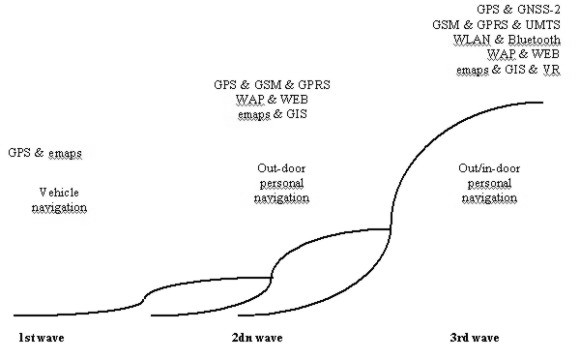
The services should be easy-to-use. The separate development of information services for individual modes of transport is not enough. Rather, the aim should be to satisfy the needs of users more broadly – at least "door-to-door" and "just on time". The services associated with the movement of people will focus in mobile consumers but also in occupational use. 3 NAVIGATION TECHNOLOGY AND SERVICESThe development of personal navigation services can be seen as three trends:
In addition to these trends tracking of vehicles and other valuable mobile resources as well as persons and pets are also important.
Figure 1. The evolution of the personal navigation. Vehicle navigation has been under development for twenty years and the work continues. The point of departure was route-finding services especially in unfamiliar surroundings, but information serving the free flow and safety of the growing volume of daily traffic has also become important. In the 1980s vehicle navigation began to take shape as a system in which different types of positioning methods (compass & distance meter, inertia, satellite, ...) could be used to display the vehicle’s position on an electronic map of the road and street network, and the driver could be given directions accordingly. At first the system’s database was quite static (CD-ROM), but with the development of wireless data transfer in the 1990s the systems have been developed in the direction of utilising real-time data (congestion, weather conditions, etc.). Vehicle navigation has matured into a consumer product and is now in widespread use in the United States and especially in Japan. Annual sales in Europe are currently running at about half a million units. The data content and transfer format of road maps is the subject of standardisation work, and in Europe the GDG standard (Geographic Data File, ISO 14825) is widely applied. Personal navigation has as its starting point the user’s need to move about without getting lost in unfamiliar surroundings regardless of the mode of transport, and to receive guidance appropriate to his/her needs and circumstances at any given time. Wireless data transfer allows the user to be offered value added services such as information concerning his/her position, e.g. a map, or information on different kinds of services available in his/her vicinity. One might expect the development of the car phone into a pocket phone will be similarly repeated in navigation applications and products. It is already technically possible to embed satellite positioning and other positioning methods into the mobile phone. The computing necessary in satellite positioning (GPS, Global Positioning System) is being carried out by smaller and smaller microprocessors with lower and lower power consumption. In addition to satellite positioning, the network positioning of mobile phones, i.e. positioning using the base stations of the mobile phone network, is already available and new methods will be standardised. Cell-ID supported with timing advance data as well as signal level data is a part of existing networks. More advanced methods like "time of arrival" (TOA) and "enhanced observed time difference" (E-OTD) are standardised. Network assisted satellite positioning (A-GPS) is also being developed as a hybrid method. In tests assisted GPS is working even in ordinary living houses and office buildings, but the accuracy suffers of the signal reflections in built areas. The development of methods has been given added impetus by a law passed in the United States requiring that from October 2001 it must be possible to determine the location from which emergency calls are made by mobile phone with an accuracy of one hundred metres. The EU Commission is considering the implementation of a similar directive from the beginning of 2003. Indoor services extend personal navigation services to the indoor environment. The user can obtain more detailed guidance and information on the sites in which he/she is interested. The technical basis for the development is provided by rapidly developing wireless local area networks (WLAN, Bluetooth) and their associated positioning methods. If the consumer’s terminal device supports the use of a wireless local area network in addition to the mobile phone network, it opens up many opportunities for indoor services. A local area network can offer site-specific "local information" and other services such as access to the Internet. Different kinds of guidance and marketing information and their linkage to a certain location in a department store, museum, terminus and other such public spaces may be the most important aspect of personal navigation. Indoor services can also be connected to a building access control system and to control automation. The premises could be developed into an active environment in which "intelligent" objects know their positions and if necessary can communicate that information to the consumer or to some management system. 4 PERSONAL NAVIGATION SERVICE SYSTEMPersonal navigation services mean services which support the positioning of an individual, the selection and finding of a desired location, and guidance to the location on the basis of different modes of transport. The navigation services can provide guidance in indoor as well as outdoor environments. Even though many aspects of the services will be locally and nationally implemented, the service supply will be based on common international standards.
Figure 2. The personal navigation service system. Usability The technical usability of services are primarily affected by the
The user interface can be text-based, graphical, auditory, sensory (haptic) or a combination of the above. The graphical user interface is leading the way, but it is being challenged by the rapid development of speech control. The size of the device and its display as well as other characteristics (e.g. graphical resolution and number of colours) set limitations on the use of services such as maps. The operating environment and situation (e.g. vehicle control) can also significantly limit the use of services and set special requirements for the user interface. For example, the user interface and other forms of guidance, such as different kinds of graphical and spoken turning instructions, suit different kinds of usage situations. The service needs of the users vary greatly depending on the specific context of work or leisure-time usage. The different lifestyles of the users in themselves generate different kinds of needs and requirements for the content and usability of services. Terminal devices are being rapidly developed with regards processing, memory and data transfer capacities, display technologies and power consumption. Personal navigation services will be accessed using different terminal devices, such as the mobile phone, the personal digital agents and digital television, typically with the aid of generic browsers. Portable devices based on wireless data transfer are best placed owing to the nature and purpose of the services, although fixed network terminal devices will find uses, especially in the planning of journeys either in advance or at suitable service points along the route. The technical positioning of the terminal device will bring many opportunities to the development of services and significant value added to the terminal device user. Wearable computers are one trend of development in terminal devices. Information content and structure have a significant effect on service usability. The clarity, readability and understandability of information is underlined especially when using navigation and other telematic devices in traffic, e.g. when driving a vehicle. The information must not be contradictory, nor may it lead to incorrect actions and thus dangerous situations, nor may it overload the user cognitively so as to interfere with some primary function. As the devices become more versatile, the information and functions must be structured so that the risk of user overload is avoided. The usability of mobile multimedia services is affected by the entire service chain from data acquisition, transfer and delivery to the end-user. Regardless of the complexity of the service chain, the user should always be well informed about the quality of the information he/she receives and about who is responsible for its quality (e.g. the accuracy and up-to-dateness of maps, hours of service availability, price tariffs, etc.). The short time window during which it must be possible to transfer the message to the user’s terminal device and deliver it through the limited user interface in an understandable form is a special requirement of personal navigation. Services The supply of services is visible to the users as different service applications, in the background of which can be generic services and technologies (data management, customer administration, data security,…). Service applications can support all modes of transport (walking, skiing, vehicles such as the wheelchair, bicycle, motorbike, skidoo, car, taxi, bus, train, ship, plane, etc.). The services can include address, route, timetable, weather, accommodation, restaurant and other guidance, traffic and travel services as well as descriptions of any commercial and public services to be positioned. The services can help the user to find different kinds of open service points (pharmacies, service stations, flower shops, restaurants, etc.) and different kinds of events (concerts, exhibitions, sporting events, cultural and religious events, etc.). The services may be associated with different hobbies (rambling, sport, nature, fishing, hunting, boating, caravanning, the arts, etc.). The service content can be information on different kinds of sites and activities (nature trail, shopping trips, sight-seeing excursions, etc.). The nature of the information can be travel directions, historical and cultural information, marketing and product information, programme and event information, official regulations, etc. Positioning in the indoor environment will facilitate different kinds of guidance services when looking for specific indoor areas and products, as well as background and product information services when they are found (exhibitions, fairs, department stores, museums, etc.). Safety is enhanced by the automatic transmission of the terminal device’s location data when making emergency calls. Positioning and the transmission of location data can also be applied in connection with different kinds of orders (e.g. ordering a taxi, consignment of goods) and when trying to trace a lost person, animal or object. The terminal device user may also need to send information on his/her location to the home, workplace, friends, etc. Generic services mean services that are not tied to any specific application. Positioning, map and route services can be regarded as generic navigation services. Moreover, general services based on the above could be the transmission of location data to another terminal device or service centre, and surveillance based on positioning. The definition of location by means of co-ordinates is a universal generic solution and it supports the standard use of map and other location data in different applications. Maps, aerial and satellite photographs, and other types of location data, including three-dimensional models, already exist but converting them into navigation services will require refinement of the data and product development of the services. The quality, up-to-dateness and detail of the material can always be improved within the limits permitted by costs and benefits. Conversions between the co-ordinate system and the street address system are generally necessary. The limitation of map information on the basis of the user’s location or the site he/she is looking for is also a generic application, in which not only location data but also any speed and direction data in the case of a mobile site can be exploited. Calculating the route between two or more points using different criteria (shortest, quickest, cheapest, "most interesting", etc.) is also by nature a generic task. 5. VALUE NETWORKThe main points of departure for the construction of the value network are
The parties involved in the personal navigation value chain and network are
Telecom and other service operators or organisations that already have an extensive and well-established customer base are regarded as the parties with the most potential as providers of integrated services. The market can be constructed vertically with, for example, telecom operators or equipment manufacturers acting as the integrators and accelerators of service supply. From the perspective of the consumers and market renewal in the long term, it would be advantageous if the market were an open network in which competition is ensured by several jointly acting horizontal layers such as equipment manufacture, data transfer and value added services. Customers using navigation devices and services will expect them to satisfy their basic everyday needs and their desire for lifestyle and recreational services. Typical first-wave users might be people working in occupations based on or requiring mobility and consumers who can make use of navigation services in their hobbies. As safety-enhancing and different kinds of special services are developed, the elderly and physically disabled may form an important user group. From the standpoint of market development it would be important to identify at the earliest possible stage the users’ fears and concerns of the new technology and to find solutions that would allay them. The service markets are likely to be simultaneously local, national and global. The services will be implemented and gradually diversified as the terminal devices and data transfer technologies develop. The starting point should be a service interface based on common international standards, which will promote competition in the supply of both hardware and services. A mobile portal architecture based on a local portal architecture that is scalable to different terminal devices and covers both private and public sector supply will be needed to ensure the supply of uniform and usable services for mobile users. The more extensive and diversified the service supply becomes, the more necessary it will be for the user that service indexing services are available. The user will be supported initially by the service portals but later by meta data that positions and describes the service. Then the services can be profiled and specialist search engines can help the user to find the services that best meet his/her needs. The private, public and consumer sectors not only play their own roles but also work together in close collaboration. The supply of services consists of market goods, public goods and "club goods" produced by the consumer sector itself. Inter-sectoral collaboration is often necessary in the development of new services and also in the production of goods. For example, companies can add value to the public sector’s register and map data to meet consumer needs. Companies can also provide servers and generic data management solutions to serve as a basis for consumers’ "club goods", and the public sector can support the creation of added value in their own data resources and by updating the data associated with them. Examples of synergistic collaboration areas include public transport, recreation and sports, and travel information services. The forms of collaboration between the public and private sectors are still rather undeveloped in the process of adding value to the public sector’s data resources. Rapid technological development and convergence is continuously changing the market’s starting points and giving rise to new markets for information products and services. There is a need to experiment with different kinds of collaboration models in the refinement of raw data and the creation of new services. The role of micro-enterprises as innovators of new products and businesses may be crucial. In the development of content we will see the emergence of many new distribution channels and the possibility to publish produced data content just once, followed by automatic tailoring to different usage environments. The input of consumer organisations is regarded as possessing great potential, and their possible role as collectors and updaters of information should be put to the test. Club goods may be extremely important in recreational and life-style services, which may account for a very significant share of the market for personal navigation services. The provision of generic platforms to the social innovators of user organisations may prove to be an important area of product development. 6. REGULATION AND ETHICAL QUESTIONSRegulation will play a role in guiding the development of services. The handling of personal data in most countries by the privacy protection and data security acts. The monitoring and surveillance of a person is also subject to interpretation of the criminal law concerning domicilary peace and electronic surveillance. A law on the protection of privacy in working life might exist in most countries and is valid in certain cases. Other legal questions concern direct marketing, the ordering of services, and consumer protection as well as the copyright of data material used in the production of services, the protection of databases and trademarks – and naturally patents. The starting point for the use of navigation services will be the initiative and permission of the customer or his/her guardian. Obviously the mobile phone operator will be allowed to position the customer’s mobile phone when the customer has given his/her consent. The user him/herself must decide on the transmission of his/her location data for the purpose of ordering a value added service. The navigation service provider should clearly inform the customer about the recipients of his/her location data and on what conditions the information will be passed on. If the customer so desires, he/she will therefore make an agreement with the operator on the use of the location service. The recipients of the location data will be specified in the agreement. The points of departure for the ethical audit of navigation services are the behaviour, hopes and fears of the users. Consumers have conflicting encounters with new products and they are not always aware of what needs the products are supposed to satisfy. The products gradually find unexpected uses and contribute towards changing the culture. Key questions include what kind of human concept or world view is in the background and whose interests does the development serve. Personal navigation throws up many ethical questions and gives rise to many fears on the part of users. Will there be an explosive growth in the amount of "tracking" data and how will the use of location data for controlling consumers be avoided? How can the user cover his tracks if necessary? There are major differences between people and different groups in the adoption of technology. Will those who quickly adopt the technology gain a significant advantage over those who do not, and will the new services lead to inequality? In the future will ordinary people be able to manage without a navigator? How will the new technology change people and the culture – will it lead to a helpless dependence on the technology? The following tensions and conflicts are common when new innovations are encountered:
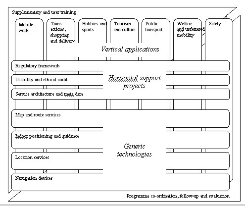
These conflicts and tensions are equally apparent in individuals and in organisations. 7. PERSONAL NAVIGATION (NAVI) PROGRAMME IN FINLANDPersonal Navigation (NAVI) research and development programme will include research, product and service development, regulation, awareness activities, education, follow-up, co-ordination and strategy work. The programme will last three years (2000–2002) and target level for the overall budget is EUR 15–20 million, half of which would be funded by the public sector. There are about 90 members most of which are enterprises in the NAVI Network covering the whole value chain. The programme consists of the following elements:
The application-specific pilot projects utilise predominantly the same terminal devices and other generic technologies. Largely the same questions and problems concerning usability, service interfaces and regulation are encountered in the pilot projects. It is therefore necessary to include in the programme, on the one hand, horizontal support projects and, on the other, areas of generic technology that will yield universal, application-independent technical solutions. The development and orientation of supplementary training in order to raise the level of expert knowledge will be necessary in both technical questions and the implementation of applications. It will also be necessary to train different types of users in order to carry out trials and collect experiences. The purpose of follow-up, evaluation and programme co-ordination is to produce information for decision-making and strategic work. In the development of services in the different programme areas the goal will be, where possible and taking account of the nature of the service, independence of distribution channel and terminal device (mobile phone, PC, digital television, …). With regard to practical trials it will necessary to select areas and locations, where trials will be made for as long as network positioning services and other location services are not available nationwide. Interaction between co-ordination and the application projects will be necessary here as well.
Figure 3. Structure of Personal Navigation (NAVI) Programme in Finland. CONCLUSIONLocation-based services and personal navigation have a huge potential. Over hundreds of millions of users have been estimated to exist in the year 2005. The location services and geographic information infrastructure will be taken in use by consumers who perhaps have never heard about coordinate systems. First time in the history of mankind the maps and geographic information in general will meet a real mass market. Shall that change anything, we will see. BIBLIOGRAPHYDurlacher Research. Mobile Commerce Report. London November 1999. Durlacher Corporation Plc. http://www.durlacher.com/fr-research-reps.htm Draft new work item proposal: Geographic information - Location Based Services Tracking and Navigation, ISO/TC 211 N 1063, 2001-02-12 Draft new work item proposal: Geographic information - Location Based Services Possible Standards, ISO/TC 211 N 1062, 2001-02-12 Jeremy Green, Dario Betti, John Davison. Mobile Location Services – Market Strategies. London December 2000. Ovum Ltd. Location Interoperability Forum (LIF) Statement. May 2000. http://www.locationforum.org/documents/LIF-Statement.pdf Rainio, Antti (ed.). Personal Navigation. NAVI Programme 2000–2002. Espoo 2000. Technical Research Centre of Finland, VTT Research Notes 2023. http://www.inf.vtt.fi/pdf/tiedotteet/2000/T2038.pdf CONTACTAntti Rainio 26 March 2001 This page is maintained by the FIG Office. Last revised on 15-03-16. |