THE PILOT PRODUCTION OF TOPOGRAPHIC-CADASTRAL MAPS AND ITS APPLICATIONS IN KOREAProf. Yun-Soo CHOI and Prof. Byung-Uk PARK, KoreaKey words: NGIS, Thematic map, Topographic-cadastral map, Administrative boundary map, Data model. AbstractThe Government confirmed the action planning of digital mapping project for major thematic maps based on 'Revised Plan for The Development of the National Geographic Information System' (NGIS). Mapping for major thematic maps was begun in 1998 when digital mapping project for topographic maps finished due to the delay of the action planning, and will selectively have produced the essential digital thematic maps according to the frequency of usage by the year of 2000. The models of topographic-cadastral maps and administrative boundary maps around Suwon were produced in accordance with the presented draft. We presented specification for production of the most appropriate topographic-cadastral maps and administrative boundary maps through the analysis of the process of production, discussion and error check, and correction of the produced topographic-cadastral maps and administrative boundary maps. And we could make it easier to develop digital mapping project of topographic-cadastral maps and administrative boundary maps effectively by presenting the strategy for data input and maintenance, the cost model for carrying out the digital thematic map production, digital topographic maps, and the supplement of data model and data format. Topographic-cadastral maps has a wide range of usage but a lot of difficulties in the process of production and map update under use. So it seems that the study on users, university, private sector and municipal self-government must follow for promoting the use of topographic-cadastral maps. 1. PREFACEIn addition to national base map, converting major thematic maps into digital map can have the widespread effect on extending GIS market and on the use of GIS because it can cause vast potential demands and is applicable in various fields. It often happens that the location of relevant parcel should be identified on the present topography when a public agency plans and manages administrative affairs. Because topographic map and cadastral map are correlated with each other, they are often used together. However, cadastral map is the data related to the ownership, so it has a limited use. Some troubles can be caused because there is a miss matching part when topographic map and cadastral map are overlapped. Consequently in this study topographic-cadastral map was pilot-produced and the most suitable specification for topographic-cadastral map production was presented through overlapping them, taking Suwon as example. It can be used in administrative department and private sector which aren't related to land ownership. 2. ANALYSIS OF THE PRESENT CONDITION OF TOPOGRAPHIC-CADASTRAL MAP AND USERS' DEMANDS FOR IT2.1 The present condition of topographic-cadastral map2.1.1 Topographic map Topographic map usually approved as National Base Map is the map which is produced and distributed by National Geography Institute (NGI). And it is one of the accomplishments made by basic survey (Article 1 of the Surveying and Mapping Law). There are maps drawn on a scale of 1/5000, 1 /10,000, 1/25,000, 1/50,000, 1/100,000, and 1/250,000. A map is designated as base map when it is standardized, accuracy is uniformed and it is drawn on the largest scale. Digital mapping project of topographic map is superintended and implemented on the basis of the master plan for the development of the National Geographic Information system by National Geography Institute, geographic information subcommittee. There are 5 subcommittees in NGIS: coordinating and planning subcommittee, geographic information subcommittee, land information subcommittee, standardization subcommittee and technology development subcommittee. Digital map is produced on the basis of Specification for Digital Mapping at Scales between 1/1000 and 1/25,000 and classified into 9 Layers such as rail way, stream, road, building, tributary, institution, topography, administration, regional boundary and cycle. Feature code which belonged to Layer is given 750 definitions and consisted of the 4 level NGI feature classifications -first, second, third, fourth level. 2.1.2 Land cadastral map Cadastral map is cadastral map and forest cadastral map. It is
cadastral records for registration and official notification of
boundary which shows shape of parcel and extending scope of a real
right like land ownership. Cadastral map is a map which shows boundary of parcel registered in cadastral land book, and cadastral forest book is a map which shows boundary of parcel registered in cadastral forest book. There are cadastral maps drawn on a scale of 1/500, 1/600, 1/ 1,000, 1/1,200, 1/2,400, 1/3,000, and 1/6,000 , and cadastral forest maps 1/3,000 and 1/ 6,000. 2.2 Analysis of users' demandsThe survey consisted of 40 questionnaires concerning topographic-cadastral maps. It was analyzed users' demands of 375 institutions and companies. About 40 % out of them responded to the survey. 1) Concerning thematic map
2) The sequency between digital map and thematic map
3) Concerning land cadastral map
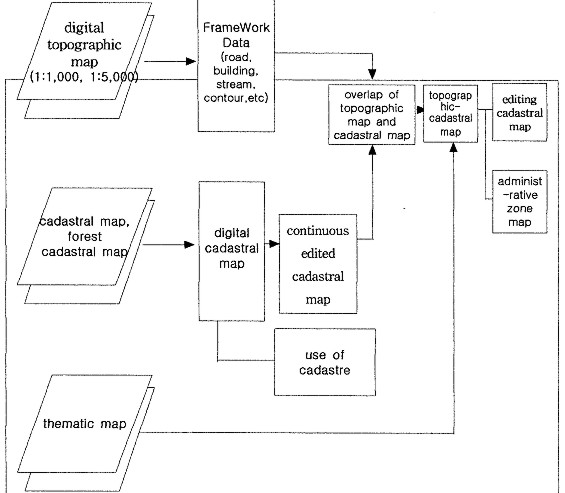
3. THE MEASURES FOR DEVELOPING AND USING TOPOGRAPHIC-CADASTRAL MAPSAs a result of survey, the measures were decided for developing topographic-cadastral maps by way of digital topographic map as follows, analyzing preliminary work and considering the scope of use. 3.1 The scope of using topographic-cadastral mapsIt was important to understand what the user's demands for information of land was when developing thematic map related to land. The demands for information of land could be classified as follows. Firstly, it was the original sheet of cadastral map computerized into a sheet of land cadastral map (forest cadastral map). This satisfied the demands for administrative affairs handled on the basis of land cadastral map. It should maintain the original shape and needs the accuracy. Secondly, it was the continuous edited cadastral map for parcel address made through matching each sheet according to administrative district or a reduced scale. This map was necessary to understand the present state by using real land cadastral map or to conduct basic analysis like writing out statistics and research. This continuous land cadastral map had some problems such as miss matching between cadastral maps and forest cadastral maps, discrepancy between current state and cadastral map, and miss matching between cadastral map edges. It was due to the problems caused in restoring expired survey control point, the problems with the control point and survey technique caused during the period of writing. It ran short of accuracy compared with original maps but it was used in administrative department. Thirdly, it was topographic cadastral maps and continuous cadastral maps made by way of using topographic map and land cadastral map. They were necessary to overcome the double work when we were establishing each plan, drawing topographic map and notifying it. Because topographic-cadastral maps were edited in accordance with real topography, there is only a little change in the shape of parcel. But the location was so accurate that they were necessary for conducting the work associated with the land like establishment of plan and the expectation for the effect was high. The result of survey on the use according to each work of municipal self-government showed that 50% work was conducted at city offices and 57.6 % work at district offices using land cadastral map and topographic map at the same time. 3.2 The measures for developing topographic-cadastral mapsAs a result of survey, the direction was presented for developing topographic-cadastral maps, considering the scope of use and analyzing the preliminary work. First a sheet of digital land cadastral map was produced after photocopying register of parcel coordinates and scanning land cadastral map. Next it was edited into continuous cadastral maps and developed topographic-cadastral maps by overlapping digital topographic maps and cadastral maps. After producing respectively three kinds of maps such as a sheet of digital cadastral map, continuous edited cadastral map for parcel address and topographic-cadastral maps, they could be used according to the purpose of use and usage. When digital topographic maps were chosen and used, they should be suitable to a reduced scale of land cadastral maps of target area to prevent repeated investment, to connect and integrate with other GIS afterward. Administrative zone map was produced through administrative district code (law district code) input in topographic-cadastral maps as attribute data. A sheet of digital cadastral map was produced for the following computerizing process of land cadastral map, based on the specification for digital cadastral map. (Figure 1. Developing and using topographic-cadastral maps) There were two ways for topographic-cadastral map production. One was to overlap land cadastral map on topographic map, a base map. The other was to overlap topographic map on land cadastral map, a base map. When using cadastral map as base map, there were so many different reduced scales that miss matching of edge area was caused. And the data of topographic map was too much for coordinate transformation to overlap it on land cadastral map. Consequently in this study precise process was presented and topographic-cadastral map was pilot produced based on overlapping the land cadastral map. The map should be easy to edit, had a little information and was drawn mostly with a straight line considering digital topographic map as base map.
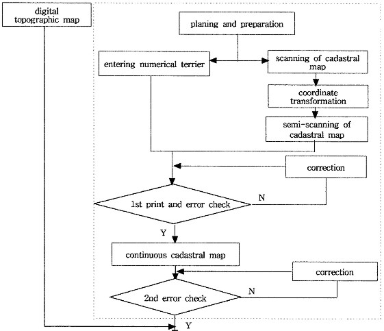
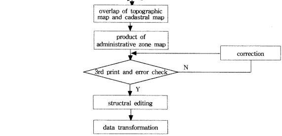
Figure 1. Developing and using Topographic-Cadastral Maps 4. THE MEASURES FOR PILOT PRODUCTION AND IMPROVEMENT4.1 Pilot productionIn this study a sheet of digital cadastral map for parcel address was produced after scanning of land cadastral map and photocopying cadastral map based on a sheet of topographical map of Suwon drawn on a scale of 1/25,000. After that continuous edited cadastral map and topographical cadastral map were developed using it. The important process of pilot production of topographic-cadastral map is as follows (Figure 2. Work Flow of Topographic-Cadastral Map Production)
Figure 2. Work Flow of Topographic-Cadastral Map Production
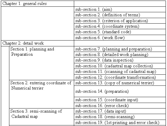
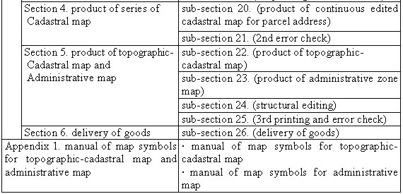
4.2 The measures for improvementWhen maps were pilot produced taking Suwon as example in this study, there was no guidelines for topographic-cadastral map production. The measures presented in the process of pilot production are as follows. 1) The problem of datum origin Then Korean government established local datum in Kyeonggi province and Daegu, and surveyed them before Korea land survey project. These were called old geodetic datum areas. Suwon, a model area for pilot development, was the place where Korea geodetic datum and old geodetic datum were adjacent. This was the place which had a difficulty in edge matching because sheet lines were overlapped when putting together cadastral maps. After understanding precisely old geodetic datum included in the cadastral map, digital data of land cadastral map of old geodetic datum area was coordinate transformed into the coordinates of Korea geodetic datum. For this, displacement of geodetic datum, azimuth and rotation angle were calculated, and used as parameter for coordinate transformation of break point of boundary. 2) The problem caused when merging maps It was solved to accord the boundaries of the area adjacent to edges of land cadastral maps by way of GIS and S/W. The discrepancy between sheets of cadastral maps was found in the boundaries of adjacent edges as well as in the case of being adjacent because law district was changed according to a equally reduced scale. It was also found when sheets of differently reduced scale were adjacent and when sheets of disagreement area between cadastral map and present surveying result in a equally reduced scale were adjacent. When adjacent edge lines between each sheet were in discord, the shortest boundary point of parcel in both ends of edge area was connected by a straight line and the other lines were eliminated. When the lines were overlapped, cadastral limit was closed in one map and the cadastral limit of the other was not closed. In this case, the closed cadastral limit was restored and the unclosed cadastral limit was eliminated. When the cadastral limit of small scale map was isolated in an adjacent area of different scaled maps, it was eliminated on the basis of the cadastral limit of big scaled map. In the case parcel which was not related to surroundings was overlapped, the cadastral limit was eliminated according to parcel number. It was the best way to decide which line to choose through topographic field survey to accord different types of disagreement. 3) The problem caused when inspecting The steps of inspection on the accomplishment of pilot development were considered important when this study was under way. The ways to evaluate the quality and the accuracy of thematic map were various according to the types of data and the way of inspection. The evaluation of the quality of data was for deciding whether thematic map was suitable to target usage, and it was divided into two ways: one was to evaluate absolute accuracy to compare input thematic map with feature of real world and the other was to evaluate relative accuracy between graphic information of produced thematic map and attribute information. Whole number inspection, sample inspection, overlapping inspection, computer inspection and automatic inspection appeared to be appropriate ways to inspect thematic map. The process of real inspection was in the order of inspection with naked eyes, inspection of screen, inspection by digital map program and inspection of completion. At first all was inspected on the basis of 80% sampling but 85% sampling was used for inspection with naked eyes and screen inspection to improve the accuracy. Eventually in the cases of inspection by digital map program and completion inspection, the accuracy of accomplishments was improved through whole number inspection. 4) The measures for improvement of digital topographic map As the project of development of NGIS started, computerization of topographic map which was national base map was conducted during the short period. Because of this reason following correction and supplement were needed. In the case of disagreement between topographic map and present topography, it cost a lot of money and took time for surveying extra correction or research again on it. The measure should be taken to make use of the accomplishment of development of GIS conducted in municipal self-government or public institution rather than conduct extra project. Next step was data modelling and format. Format of digital topographic map and layer system should be added and supplemented in accordance with use of GIS in various fields. Korean Framework Data should be developed for making the most of digital topographic map, for improving accuracy and preventing double investment on the development of data during the process of thematic map production. It was also necessary to simplify and standardize the way of transcribing on the present digital topographic map. For example when road center line was drawn, an imaginary center line was drawn on the crossing when one-way street and both-way street crossed each other. In the case one-way street and both-way street crossed, an imaginary road center line was drawn on the one-way street and on the node in the center of crossing. When each feature was drawn like this, it was necessary to review classification system and classification method for classification of feature, considering the importance of each feature. 5. GUIDELINES FOR TOPOGRAPHIC-CADASTRAL MAP PRODUCTIONIn this study guidelines for topographic-cadastral map production was presented through pilot production. It consisted of chapter 1 (General rules) and chapter 2 (detailed work according to process and annexed standardization of map symbols). Chapter 1 included general contents such as aim, definition of the term, coordinate, standard feature code and work flow. In chapter 2, the course of work was detailed. Table 3 is the content of guidelines for topographic-cadastral map production presented in this study (Table 1. The specification for topographic-cadastral map production presented during pilot production) Table 1. The specification for topographic-cadastral map production presented during pilot production
6. CONCLUSIONIn this study topographic-cadastral map which was often used among major thematic maps was pilot produced for case city of Suwon according to detailed plan for digitalization of major thematic map. It was included in master plan for the development of NGIS. The conclusion was as follows.
Consequently topographic-cadastral maps can be used widely in many fields but they have many difficulties caused during the process of production and the problems concerning reform of maps which were being used. It was concluded that user-oriented study at municipal self-government, private sector or university was more necessary, which meant the study on the fields using topographic-cadastral map as base map although it was good to maintain accuracy and make use of digital cadastral map. REFERENCES
CONTACTProf. Yun-Soo Choi Professor Byung-Uk Park 15 April 2001 This page is maintained by the FIG Office. Last revised on 15-03-16. |