A NEW COORDINATE SYSTEM FOR IRELANDMichael CORY, Roy MORGAN, Colin BRAY and Iain GREENWAY, UK and IrelandKey words: coordinate reference systems, GPS, geodesy. 1. INTRODUCTIONOrdnance Survey Ireland (OSi) and the Ordnance Survey of Northern Ireland (OSNI) are the national mapping organisations responsible for the surveying and mapping of Ireland and Northern Ireland. Amongst their other duties, they are jointly responsible for the development of a geodetic framework on which all of the island's mapping is based, hence for ensuring that mapping on the island "fits together". The Global Positioning System (GPS) enables precise positioning anywhere on earth with a precision of a few millimetres, if an appropriate reference frame and positioning infrastructure is in place. Mapping in Ireland, however, as in many places around the world, is based on a different geodetic datum from that used by the GPS. Although transformation formulae and parameters are available between Irish Grid and the European Terrestrial Reference System (ETRS89), it is beneficial, particularly for GPS users, to associate a map projection with ETRS89. A projection allows three-dimensional ETRS89 coordinates to be converted to a two-dimensional form that can be plotted on a map. This maintains the quality and precision of GPS for surveying and mapping purposes, and simplifies GPS positioning on all Ordnance Survey mapping products. This paper sets out the reasons behind OSi and OSNI's decision to implement a new coordinate system for Ireland, the projections chosen, and the implications for users. 2. BACKGROUND AND CONTEXTIrish GridThe current Irish Grid coordinate system used by OSi and OSNI is based on a rigorous adjustment of a triangulation network, the origin of which dates back to the 19th century. The re-triangulation of Ireland and Northern Ireland in the 1950's and 1960's resulted in the Ireland 1965 datum from which latitude and longitude positions were computed in the Ireland 1975 (Mapping) Adjustment, on a modified Airy ellipsoid (OSi 1996). A Transverse Mercator projection was used to convert the latitudes and longitudes into 2-dimensional grid coordinates for mapping purposes. The original parameters for the Irish Grid specified a scale factor of unity on the central meridian and applied to the Airy ellipsoid. Discovery of scale errors in the network resulted in the adoption of a scale factor of 1.000035 on the central meridian and introduction of the modified Airy ellipsoid to compensate. It is generally accepted that this scale factor is unusual (being greater than unity on the central meridian) and is partially due to shortcomings in measurement technology (including EDM equipment) at the time. Additional details and description of the datum and adjustment are contained in (OSi 1996). ETRS89 and IRENET95The advent of satellite positioning systems in the 1960's, and specifically GPS in the 1980's, allowed the development of techniques for determination of precise global positions. These techniques are capable of improving positioning by a factor of 10 compared to traditional methods, and can expose the limitations of existing control networks. This has proved to be the case in Ireland. In 1994, OSi and OSNI jointly agreed to establish a new geodetic control network in Ireland based on ETRS89. The scheme was largely observed during 1995 and 1996, and the resulting network is known as IRENET95. This network complies with international standards and provides high precision, distortion free control for GPS surveys. In order to establish compatibility between ETRS89 and the Irish Grid, OSi and OSNI commissioned the Institute of Engineering Survey and Space Geodesy (IESSG) at the University of Nottingham to determine the most appropriate mathematical transformation. As a result of this, and further research, transformation parameters between Irish Grid and ETRS89 have been determined (OSi/ OSNI 1999). 3. THE NEED FOR A NEW PROJECTIONMathematical transformations cannot provide exact results; consequently they only partially realise compatibility between the Irish Grid and ETRS89. Applying a transformation to precisely surveyed positions results in distortion of the accurate GPS measurements to make them fit a less precise control network. It is more appropriate to maintain the accuracy of the survey by using mapping that is compatible with GPS, thus allowing surveys and mapping to be combined without the introduction of distortion. Therefore, to benefit fully from the accuracy achieved by IRENET95, both surveys and mapping should be based on this control network and datum. In addition, surveyors, engineers, navigators and a wide range of professional users, as well as the general public, increasingly use GPS and wish to be able to relate GPS positions to Ordnance Survey mapping unambiguously and quickly, without having to consider datum transformations, map projections, or the distortions inherent in the older mapping. It is therefore desirable that OSi and OSNI provide mapping that is compatible with GPS. ETRS89 positions derived using IRENET95 control are three-dimensional, in the form of Cartesian or geographical coordinates. However, because ETRS89 relates to a different geodetic datum than Irish Grid, it follows that the ETRS89 latitude and longitude of any point differ from the Irish Grid values. To calculate grid coordinates from latitude and longitude requires that a map projection is associated with the new geodetic framework, thus providing two-dimensional grid coordinates that can be shown on a map. However, the grid coordinate obtained is dependent on the ellipsoid and projection parameters used. ETRS89 relates to the GRS80 ellipsoid (Moritz 1980), not the modified Airy ellipsoid used by the Irish Grid. By projecting onto different ellipsoids, different grid coordinates are obtained. However, the difference between the two sets of projected coordinates is only in the order of 55m. This is not large enough to identify which ellipsoid was used, and as a consequence introduces confusion. It is therefore desirable to alter the projection parameters sufficiently to differentiate between the coordinate systems used. The time is therefore ripe for the introduction of new map projections for Ireland to ensure full compatibility with GPS. This also provides an opportunity to address historic datum anomalies. The new projections need to be associated with the accepted global reference ellipsoid, GRS80, and associated coordinate system, ETRS89. 4. NEW PROJECTION OPTIONSThe projections adopted by OSi and OSNI must fulfil several criteria. They are intended to be GPS compatible, and therefore must be associated with ETRS89 and the GRS80 ellipsoid. They must also be orthomorphic or conformal (that is, preserving local shape), and they must minimise mapping distortion throughout Ireland and Northern Ireland. The projections should also be based on formulae that are readily available. Additionally, they must allow compatibility with current mapping to be maintained. The Transverse Mercator projection has been identified as the most suitable type of map projection by OSi and OSNI, for the following reasons:
Mapping distortions caused by the projection are dependent on, and can be minimised by, the choice of suitable parameters. Therefore, the following three forms of Transverse Mercator projection have been considered:
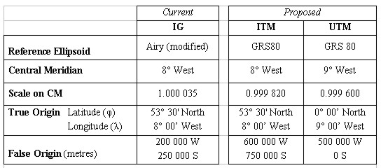
The projection parameters for the IG, UTM and ITM are listed in Table 1.
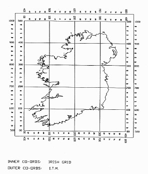
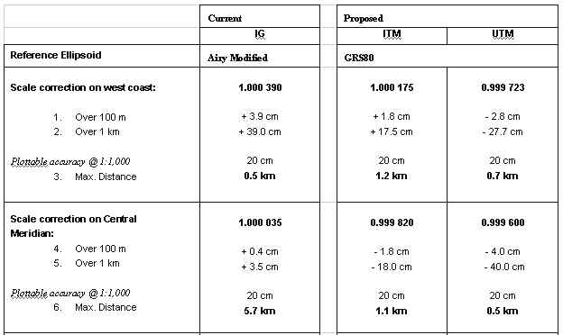
Table 1: Map Projection Parameters Irish Grid (IG)Originated as a classically derived Transverse Mercator projection, the IG was defined to meet the above criteria. The 1975 mapping adjustment resulted in alteration of the scale factor on the central meridian to 1.000035. The parameters associated with IG are unsuitable for a proposed GPS mapping projection associated with the ETRS89 and the GRS80 ellipsoid. Applying these parameters, the difference between the projected ETRS89 and Irish Grid coordinate of a point is in the order of 55 metres. It is anticipated that this will introduce confusion regarding the coordinate system and projection used to derive any given point. Moreover, because of the adjusted scale factor on the central meridian, the effects of mapping distortions are not minimised. UTMUTM is an internationally recognised and widely available standard projection in mapping and GIS software. It divides the earth into sixty zones, between latitudes 84º North and 80º South. Each zone is 6º wide, with a scale factor of 0.9996 applied on the central meridian (Snyder 1987). Ireland is situated in UTM Zone 29, which has a central meridian 9º West of Greenwich, resulting in a small part of Counties Antrim and Down in the east of Northern Ireland extending outside the nominal zone width boundary of 6º West of Greenwich. However, the zone width may be altered to meet local circumstances and since the UTM grid has a standard zone overlap of 40 km on either side of a zone boundary, all of Ireland can be contained within Zone 29. Since the central meridian lies along the West Coast of Ireland, mapping distortions are not distributed evenly. In addition, applying UTM to Ireland results in coordinates that have a 7-digit northing and 6-digit easting, compared to the current IG reference system, which has 6 digits in each. ITMITM is a newly derived projection that may be associated with ETRS89 and the GRS80 ellipsoid. The true origin and central meridian defined in the Irish Grid are maintained, thus distributing the distortions due to the projection evenly. Consideration was given to the introduction of a scale factor of unity on the central meridian. However, using a scale of 0.99982 (see Appendix A) results in two standard parallels, and the magnitude and effects of scale change are minimised. The position of the false origin is moved to a point 600,000m west and 750,000m south of the true origin. This results in grid coordinates that are significantly different from IG, but does not introduce additional distortion or complexity. The magnitude of the shift ensures that IG coordinates plotted on the ITM projection do not fall on Ireland or Northern Ireland, and vice versa (see Figure 1).
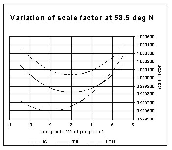
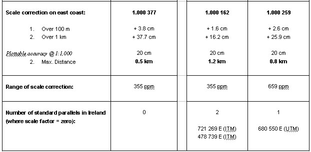
Figure 1: ITM and IG coordinates for Ireland 5. COMPARISON OF THE PROPOSED PROJECTIONSThe effects of the three projections have been compared in relation to scale correction, area and convergence; figures are included in Appendix B. Scale CorrectionFor Transverse Mercator projections, scale correction is a function of grid distance from the central meridian. It is therefore constant for any given easting, and is independent of the northing. The range of scale correction resulting from both IG and ITM is 355 ppm, whilst UTM has a range of 659 ppm. However, IG does not have a standard parallel (where scale is unity). Although UTM has one standard parallel, the location of the central meridian results in larger scale corrections on the West Coast. Since ITM is secant and centred on Ireland, it provides two standard parallels (see Figure 2).
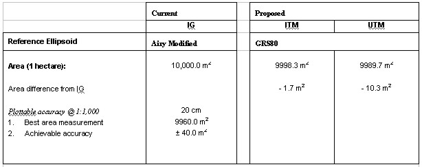
Figure 2: Variation of scale factor at 53° 30' N AreaCurrently all areas are computed by OSi and OSNI directly from the mapping (IG on the Airy modified ellipsoid), without applying scale corrections. Since all survey observations are reduced to the reference ellipsoid before being projected onto the mapping, changing the ellipsoid will introduce changes in the areas shown on maps. To quantify the magnitude of the change, an area of one hectare (100m x 100m) on the current mapping was re-projected onto UTM and ITM. Applied to UTM, the largest change in area occurs on the central meridian at 9° West of Greenwich, and results in a decrease in area of 10.3m2 (0.1%). Similarly, the worst-case for the proposed ITM mapping system occurs on the ITM central meridian at 8° West of Greenwich, and results in a decrease in area of 1.7m2. Using the current IG projection parameters applied to the GRS80 ellipsoid results in an area increase of 2.4m2. When using a 1:1,000 scale map it is only possible to plot to an accuracy of 20cm, which results in a possible error in the area measurement of ±40 m2. This is significantly greater then the area change resulting from a change in projection and therefore the effect on area measurements can be considered negligible. ConvergenceIG and ITM both use the same true origin and central meridian, and therefore using ITM projection parameters does not affect convergence. Furthermore, the change in the size of the ellipsoid from the modified Airy to GRS80 is not large enough to affect the calculated convergence. Adopting UTM implies a central meridian at 9° West, which results in an increase in convergence of between 47' and 50'. At the extremes of the projection this increases convergence from 2° 03' 39" to 2° 53' 08". 6. IMPLICATIONS AND PROPOSALSAs described in previous sections, any new projections should minimise distortions within the new mapping system and realise ETRS89 coordinates that are substantially different from the existing corresponding Irish Grid coordinates (thus avoiding confusion). These criteria immediately rule out the possibility of maintaining the current projection parameters. However, both ITM and UTM will provide coordinates that are significantly different to IG. With regard to scale correction, UTM produces the largest scale correction, of -400ppm or 40cm per km on the central meridian. This becomes significant when plotting measurements of greater than 500m. UTM also provides the largest range of correction (659 ppm). The location of the standard parallel requires that corrections of greater than 200ppm are applied to all observations west of a longitude of 7º west. ITM, however, minimises and evenly distributes scale corrections, with a maximum scale correction of 180ppm on both the central meridian and the extremes of the projection. Positioning the central meridian in the centre of Ireland at 8º west also results in even distribution of convergence and t-T corrections. The location of the UTM central meridian produces increases of 50' in the convergence calculated along the East Coast. The adoption of either UTM or ITM map projections has no significant effect on area measurements. This paper has described the complexities introduced when attempting to make GPS measurements fit onto existing mapping. The growing numbers of GPS users, most of whom have no interest in issues such as transformations and adjustments, will therefore be best served by a mapping system which is fully compatible with GPS. There are, however, very many existing users of OSi and OSNI mapping. Many of these have associated their own data with the mapping data and therefore have significant databases using IG coordinates. There is substantial effort involved in converting these large databases into a different coordinate reference system. Adoption of new projections may also have subsequent effects on users' map cataloguing systems. Any proposed change cannot ignore the needs of these users. Whilst recognising that the majority of map data users in Ireland will not be concerned about the international compatibility of their work, there are important applications which will benefit significantly from such compatibility. Although UTM, for the reasons described, is not the ideal map projection when considering Ireland in isolation, it is an internationally recognised standard, and is likely to be adopted by the European Commission for its mapping needs. Consequently, OSi and OSNI intend to adopt the following policy:
7. FURTHER WORKConsultations with the main user groups on the proposals above are currently underway, having begun with an introductory leaflet in December 2000 and continued with a technical consultation paper in February 2001. Seminars will be held around Ireland in April 2001 and decisions on a number of issues will be announced in May 2001. Wide consultation and education is seen as vital in this very significant change. Particular areas for consultation include the timescale within which users can accommodate changes, the coordinate reference system to be used for small-scale maps, and how product design can be used to assist in the easy identification of the projection being used for any particular map. OSi has converted its data collection and storage processes to use ITM as its internal coordinate system, thus preserving the accuracy of GPS work; OSNI has not, at this stage, made this change and is currently considering options. In addition, to support the wider use of GPS in Ireland, OSi and OSNI are also currently in the process of installing active GPS networks which are planned to be in operation by the end of 2001. Use of ETRS89 requires that the GRS80 ellipsoid is used. Since the geoid in Ireland is not coincident with this ellipsoid, appropriate reductions must be applied when carrying out precise surveys. To further improve compatibility of OSi and OSNI products with GPS, therefore, a precise geoid model for Ireland (as part of a wider contract to create a precise model for the British Isles) will also be put in place during 2001. 8. CONCLUSIONSDuring 2001, OSi and OSNI will introduce new mapping projections for Ireland. By using the national control network, along with OSi and OSNI mapping projected in ITM or UTM, GPS surveys can be combined with national mapping while still maintaining survey accuracy and avoiding the current requirement to compute or apply transformations. It is further anticipated that the proposed new map projection, ITM, will simplify and encourage the use of GPS with OSi and OSNI products. Compatibility between the new projection and the existing Irish Grid will be maintained using derived transformations. The new projection options have therefore been designed to cater for existing map users, GPS users, and those users who require direct conformity with international systems. In this way, OSi and OSNI are fulfilling their obligations, as national mapping agencies, to meet the needs of all map and map data users, present and future. REFERENCESMortiz, H., 1980, Geodetic Reference System 1980 (GRS80), Bulletin Geodesique volume 54 OSi, 1996, The Irish Grid, OSi, Dublin OSi/ OSNI, 1999, Making maps compatible with GPS, OSi, Dublin/ OSNI, Belfast Snyder, J.P., 1987, Map Projections - a working manual, USGS paper 1395 APPENDIX A: SCALE FACTOR ON THE CENTRAL MERIDIAN FOR ITMThe longitudinal extent of Ireland is from approximately 5° 25' to 10° 30' west of Greenwich. Minimum distortion will be achieved if the central meridian bisects these, i.e. at 7° 57' 30" west of Greenwich. Obviously, it is desirable to simplify the parameters involved in the projection; therefore, this was rounded to 8° west of Greenwich. To select the scale factor on the central meridian three options are available:
The third option produces two standard parallels and allows the magnitude of the scale corrections to be minimised throughout Ireland. Scale factor at a point is calculated from the formula:
Assuming a central meridian at 8° W, and a scale factor of unity on the central meridian, the maximum scale factor applying to Ireland was calculated as 1.000370 at approximately 10° 30' W, 51° 30' N, giving the range of required correction as 370 ppm. Since the curve obtained from the above formula is symmetrical, the minimum magnitude of the required correction is obviously achieved by assuming a scale factor on the central meridian of 1-370ppm/2, i.e. 0.999815. This was rounded to 0.99982 to simplify the parameters involved in the projection. This has the added benefit of moving the position of the standard parallels towards the central meridian and, due to the geography of Ireland, increases the land area where scale is unity. APPENDIX B: COMPARISON OF PROJECTION TYPES1. Scale Correction
Table 2: Comparison of the effects of Scale Factor between the three projections 2. Area CorrectionTable 3 below shows a direct comparison between a current IG area measurement and the worst-case area differences in the ITM and UTM mapping systems:
Table 3: Area Comparisons BIOGRAPHICAL NOTE OF THE PRESENTERIain Greenway joined Ordnance Survey of Great Britain in 1986 after completing an M.A. in Engineering at Cambridge University and an M.Sc. in Land Survey at University College London. A variety of posts in geodetic and topographic survey followed, including short-term consultancies supporting land reform in eastern Europe. After completing an MBA at Cranfield University in 1994/95, which included a term studying at Macquarie University, Sydney, he worked for Ordnance Survey in strategic planning and pricing, sales and marketing, as well as completing a number of management consultancy inputs in Swaziland and Lesotho. He subsequently undertook a secondment to Her Majesty's Treasury, working on the improvement of public sector productivity in the UK. Since the summer of 2000, Iain has been the Deputy Director of Ordnance Survey Ireland, responsible for much of the day-to-day management of a national mapping agency undergoing profound changes in status, structure, processes and culture. Iain is a Chartered Surveyor (MRICS) and a member of the Chartered Institute of Marketing (MCIM). He is the RICS delegate to FIG Commission 1, Chair of the FIG Task Force on Standardisation and of Working Group 1.2 (Business Practices). He is also a member of the Management and Editorial Boards of the journal Survey Review. CONTACTMichael Cory and Roy Morgan Iain Greenway and Colin Bray 14 April 2001 This page is maintained by the FIG Office. Last revised on 15-03-16. |