|
|
JOINT COMMISSION WORKING GROUP ON
UNDER-REPRESENTED GROUPS IN SURVEYING
 Visit the Web site of the
FIG Working Group on Under-represented Groups in Surveying
Visit the Web site of the
FIG Working Group on Under-represented Groups in Surveying
This Newsletter in -pdf-format
Contents
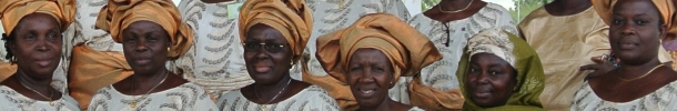
Activities during the FIG Working Week in
Cairo
Fair Competition for Minority Groups
Irene K. Fischer, Geodesist, by Wendy J.
W. Straight, LS, USA
Activities during the FIG Working
Week in Cairo
One of the specific projects of the Joint Commission Working Group on
Underrepresented Groups in Surveying is to provide guidelines for FIG in
2006. Therefore the Working Group organizes a Workshop on Wednesday 20
April 14:00-15:30, Suite 2, to discuss
Draft Guidelines to Enhance the
Situation of Under-represented Groups in FIG.
For more information please contact Gabriele Dasse:
g.dasse@gmx.de
Fair Competition for Minority Groups
One of the policy issues of the Joint Commission Working Group on
Underrepresented Groups in Surveying is to enhance fair competition for
minority groups.
- Are there any minority groups in your country which have problems
with fair competition, for example getting an order or a job? If so,
please give a short description.
- Did you make this experience by yourself?
- Is this a topic to deal with during the FIG congress 2006 in Munich?
I am looking forward to hearing from you.
Gabriele Dasse
g.dasse@gmx.de
Irene K. Fischer, Geodesist
by Wendy J.W. Straight, USA
Sputnik was launched 48 years ago, and the space age was born. Five
years prior to that, an insightful and diminutive mathematician with a
flare for languages entered a research career with the U.S. Army Map
Service (AMS). Geodetic science was ready for the world stage, and it was
in need of Fischer’s 25 years of contributions. According to Joseph
Dracup in his article Geodetic Surveying, 1940 -1990, for the National
Oceanic and Atmospheric Administration, “Irene Fischer was
recognized as the U.S. expert on datums, ellipsoids, and the geoid,
despite the fact that few results of her efforts will ever come to light.”
Although Dr. Irene K. Fischer prepared, published, or presented over
120 technical papers and reports, much of her work was classified under
military security rules. For many years, the bulk of the American
surveying community was unaware of the enormity of the Fischer oeuvre.
Fifteen years ago, her personal papers were donated to the Schlesinger
Library at Radcliffe College in Cambridge, Massachusetts. Included were
her non-classifed papers, and her memoir entitled, Geodesy? What’s That?
My Personal Involvement in the Age-Old Quest for the Size and Shape of the
Earth. Over the past year, the American Congress on Surveying and Mapping
(ACSM) has devoted much of each issue of its Bulletin to excerpts from
Fischer’s memoirs.
Her Geodetic Contributions
In his preface to the ACSM publication, Fischer’s former colleague
Bernard Chovitz referred to her as one of the most renowned geodesists
of the third quarter of the twentieth century. Yet, this fact alone makes
her one of the most renowned geodesists of ALL time, because according to
Chovitz, the third quarter of the twentieth century witnessed “the
transformation of geodesy from a regional to a global enterprise.” A
mathematician who had been educated in descriptive and projective geometry
at the Vienna Institute of Technology, Fischer insisted by 1954 that the
traditional “development,” or two dimensional, method of geodetic
computation, which led to cumulative error over long distances, should be
discarded whenever possible in favor of a “projection,” or three
dimensional, approach. She also recognized very early that latitude and
longitude, rather than plane coordinates, would better serve the global
needs of the future, and that the geographic location of a place would be
the same, no matter how computed.
Considered elementary principles today, such conjectures were radical
for a time when reference ellipsoids and useful horizontal datums existed
independently from continent to continent. However, from her outsider’s
mathematical perspective, it was the independence of those networks that
bothered her. She and her team patiently and meticulously sorted “geoid
pieces,” analyzing astrogeodetic and gravimetric data. By 1957, she
had developed the first North American geoid chart to cover the entire
continent. Furthermore, she had linked eastern and western hemispheres,
representing networks in terms of geoidal heights, minimizing them, and
deriving a world solution. Her presentations that year, and her technical
report the following year, were monumental contributions to her field.
Throughout her pursuit of the figure of the Earth she enjoyed the
relationship of that effort to other major projects in geodesy. Her
updates to geodetic science helped determine the parallax of the moon, and
during the parallax studies, her language skills provided a breakthrough:
she discovered in past literature a linguistics inaccuracy and its
resulting error in mathematics. In other outreaching activity, her geoid
studies went hand in hand with investigations of the lingering effects of
the last ice age. Fischer was intrigued by research into post glacial
uplift, and gained many friends in the geophysical community.
Other corollaries to her work were carried into the area of isostasy,
and Fischer participated in the earliest interdisciplinary studies in
marine geodesy. She was also among the earliest researchers during the
frustrating infancy of satellite geodesy, where she was instrumental in
making the first detailed comparisons of satellite to terrestrial
solutions in the world datum puzzle. Maintaining throughout her career
that her analyses of the size and shape of the Earth should not be
preempted by a few inferior conclusions of other agencies, such as the
Navy and Air Force, Fischer ultimately summarized the basis of her
research, and the multiple expansions and revisions thereof, in her
article, “The Figure of the Earth, Changes in Concepts,” for Geophysical
Surveys in 1975.
Life in the Government Sciences
At the very beginning of her career in geodesy, Fischer had quickly
taught herself the basics of geodetic tables, datums, transformations,
gravity studies, astronomy, long lines, flare triangulation, and guided
missiles. Yet, in her memoirs, she is quick to thank her mentors, such as
John O’Keefe, whom she called “the soul and driving force”
of the geodetic branch of the AMS before he left for later work at the
National Aeronautics and Space Administration. Long before artificial
satellites, O’Keefe was known to the geodetic community as a curious and
inspirational scientist, who explored extraterrestrial methods of geodesy.
His scientific enthusiasm and his natural teaching ability allowed him to
become a major influence in the adoption of the Universal Transverse
Mercator projection outside the military community.
An expert on celestial mechanics, O’Keefe had predicted at the launch
of Sputnik that geodesy would make more advances in the next 18 months
than it had in the past 50 years. In fact, he immediately acquired the
Sputnik ephemeris for the educational use of his colleagues. O’Keefe had
eased Fischer’s transition from theoretical to applied mathematics. Also,
by explaining that she was reducing the errors that could be caused by
geodetic ignorance, he had guided her through the moral dilemma presented
by the potential military uses of her work. His scientific enthusiasm and
his natural teaching ability allowed him to become a major influence in
his field, yet Fischer was not afraid to vehemently oppose his commitment
to the traditional, development approach to geodetic computation when she
knew that the three dimensional method would be mathematically correct.
Fischer’s memoirs do not hide the fact that some of her other
colleagues failed in comparison to O’Keefe’s benevolent character. Besides
her admired and respected team members, there were “cautious
bureaucrats” and “politicking underminers.” The “bureaucrats”
caused needless delays in the publication of her work. Early in her
geodetic career, publication approval took only two weeks. As she neared
retirement in the late 1970s, approval took eight weeks at a minimum.
Other bureaucratic snags denied her direct access to the UNIVAC, and
someone in the computing department tricked her by handing her an obsolete
compiler. Not allowed to engage in programming, neither was she supposed
to create her own illustrations, although she had been trained to exacting
standards when she was a young girl. The drafting and programming
assignments were the turf of other personnel in different divisions.
Bureaucrats were also at work when interagency communications were slow,
lost, or stifled. She noted that such inefficiency indicated, “the
interesting contrast between supportive and restrictive management, with
the ensuing psychological impact on the workforce.”
The “underminers” included those who deliberately claimed credit
for Fischer’s work. When she once protested, her peers surmised “that
the people ‘downstairs’ could not accept the idea that a woman could do
something important.” On another occasion, she was never given a
reason for the theft of her work, and the agency whose staff had stolen it
issued a letter stating that their work had nothing to do with hers. Later
in her career, she was mysteriously told to stay out of satellite geodesy,
an order that made her suspicious of the rationale. On still other
occasions, her well substantiated conclusions were ignored by a particular
agency, and the unsubstantiated work of others was accepted instead. This
happened in the case of the World Geodetic System of 1960, a project that
she knew to have been compromised. “For my own technical integrity,”
she said, “I pursued my plans for an unclassified updating of my
Tentative World Datum with undiminished scrupulousness, intent to produce
a technically sound product.”
Rarely, but at times, her own agency ignored Fischer’s expertise.
Working on the “Figure of the Earth” project in 1955, Fischer had
derived and wanted to utilize a value for the Earth’s oblateness of
1/298.1 (the fraction by which the polar axis is foreshortened by the
equatorial radius). In 1924, the value of 1/297 had been accepted “haphazardly,”
she said, by the International Association of Geodesy. Fischer was not
permitted to use her value, however, because she would be disagreeing with
the accepted literature. Within a short time, satellite data indicated the
oblateness of the Earth to be 1/298.3, and Fischer was vindicated.
Although the correction required her to amend her own previous work on the
world datum, for which she was not allowed to use her own derived value of
the Earth’s flattening at the poles, Fischer goodheartedly quipped that
the satellites had not accepted the literature either.
Perhaps to assuage their guilt over mistrusting Fischer’s early
computations, colleagues in her agency referred to her revised work as the
“World Datum of Irene Fischer.” She, however, pushed for acceptance
of the term “Mercury Datum of 1960.” Seven years later, she was
still revising the Mercury Datum, due to the wealth of satellite data she
had begun to accumulate and analyze. Internationally respected, she
presided over the type of discussions that continued a generation after
her retirement, debates over the appropriate time to adopt a new
international ellipsoid. Several awards and accolades were showered upon
Fischer over the years, and in 1967, Fischer received the highest awards
for civilian service from both the Army and the Department of Defense.
Likewise, she took pride in her team, and nominated members of her staff
for various awards.
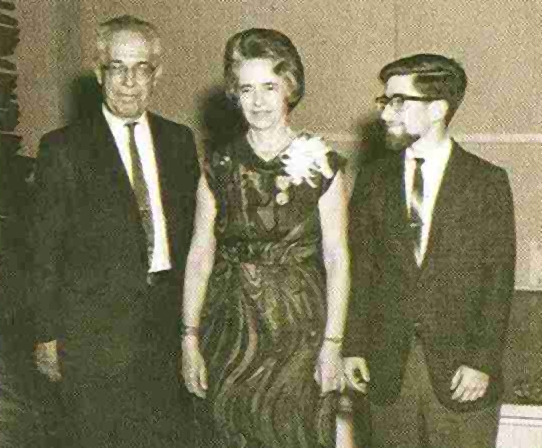
With her husband and son at her side, Irene Fischer accepts the
Distinguished Civilian Service Award from the U.S. Dept. of Defense in
May, 1967.
Significance for Today
Fischer was supportive of women in science. She admired her colleague
and assistant Mary Slutsky, in whose work she never found an error.
However, “there was no chance that one of mine could slip by her,” Fischer
commended. Women in Fischer’s office took lunch together at special times,
but Fischer was disturbed that the restaurants of Washington, D.C. would
not admit her African American colleagues in the pre-Civil Rights era. She
circumvented the problem whenever she could, by arranging private
locations for the lunches, where all of her female colleagues could
attend.
For a number of years, Fischer was fearful of attending scientific
conferences in Europe. With her husband and daughter, she had fled
her native Austria during World War II, but the trauma stayed with her.
Perhaps sensing her trepidation, European geodesists made an effort to
welcome her, and her fears eventually subsided. She remained grateful for
their courtesy, and cited them in her memoirs. “Their friendliness
erased somewhat the eerie feeling of unreality,” she said, “which
colored my stay in [Europe] about twenty years after [the
Anschluss].” She later received an honorary doctorate from the University
of Karlsruhe in Germany.
Fischer operated within the framework of the Cold War, but often in
spite of it. She was known for her generous assistance to the worldwide
geodetic community. Transformation requests came to her from countries
with no geodetic tie between them as yet. Worried that someone less
knowledgeable “might pull preposterous numbers out of thin air,”
she used the strongest information available and admitted that the best
she could do was sometimes “an educated guess sandwiched between prayers.”
Regarding her dedication to her work, she said, “I felt obliged to
enlarge the worldwide collection of geoid pieces wherever I could get hold
of pertinent information to construct one regional chart after another.”
Her geodetic career began two generations after American women had won
the right to vote, and a generation prior to the second women’s movement.
This must have been akin to having the right to speak to an audience who
had no right to listen. She knew that her work violated American myths
about women in science. Through her quiet dignity and unflagging
capability, she became a respected example of scientists in action,
dispelling the myths with every step she took. Today’s female surveyors
can and should look to her with pride in her accomplishments. The science
community can and should look to her for the extreme thoroughness with
which she investigated details. Government agencies can and should look to
her for articulate and constructive criticism of their inefficiency.
Everyone can and should look to her sense of humor and courage of
conviction.
By Wendy J.W. Straight; Professional Land Surveyor; e-mail:
wendy@netsync.net
|
Editor: Chair of the Joint Commission Working Group
on Under-represented Groups in Surveying
Ms. Gabriele Dasse,
Kleinfeld 22 a, D-21149
Hamburg, Germany
E-mail: g.dasse@gmx.de
2/05, month of issue:
April
© Copyright 2005 Gabriele Dasse.
Permission is granted to photocopy in limited quantity for educational
purposes.
Other requests to photocopy or otherwise reproduce material
in this newsletter should be addressed to the Editor.
|
|