The FIG Working Week has been cancelled. This is not a decision we have taken lightly and there are two overriding concerns that have caused us to make this decision at this time.
First, the Dutch Government announced new measurements to control the COVID-19 outbreak. In the Netherlands all gatherings are prohibited until 1 June.
Second, our primary concern is always the wellbeing of you, and we would not take on the responsibility, during these times, to bring so many surveyors from all over the world together.
As a result the plenary sessions are cancelled.
This years' programme is supported by high level presentations in three plenary sessions on topics within the overall theme 'Smart surveyors for land and water management'. These specially invited plenary speakers share insights into their own experience and pitfalls and present their vision and predictions covering the subtheme from each conference day.
Plenary Session 1 - Smart Surveyors |
||
 |
 |
 |
Jack Dangermond |
Sisi Zlatanova |
Frank Tierolff |
Surveying and Geospatial Infrastructure |
3D indoor modelling. Challenges and opportunities |
Use and applications of new technologies |
Plenary Session 2 - Integraded Land and Water Management |
||
 |
 |
|
Nick van de Giesen |
Gordana Jakovljovic |
|
New observational methods for water, weather and climate in Africa with results from the TWIGA Project |
Mapping plastic – the step forward for a cleaner environment. |
|
Plenary Session 3 - Ten years to achieve the SDG's |
||
 |
 |
 |
Emmanuel Nkurunziza |
Janet Edeme |
Menno-Jan Kraak |
Land Regularization |
Realizing Agenda 2063 and the Sustainable Development Goals Through Improved Land Governance Systems |
Save the World with Maps: Visualizing SDG Indicators |
Plenary Session 1 - Smart Surveyors |
||
 |
Jack Dangermond |
|
Founder
and President
|
||
Surveying and Geospatial InfrastructureAbstract: GIS is evolving, becoming an interconnected network of Geospatial web services. These services are increasingly being organized with next generation GIS Portals that virtually integrate data and services from many sources. As this framework emerges, it will increasingly depend on a strong foundation of survey information. This presentation will illustrate common patterns of use as well as the conceptual and technical constructs that are essential to make geospatial infrastructure emerge. Bio: A landscape architect by training, Jack Dangermond founded Environmental Systems Research Institute (Esri) in 1969 with a vision that computer mapping and analysis could help us design a better future. Under Dangermond's leadership, that vision has continued to guide Esri in creating cutting-edge GIS and Geodesign technologies used in every industry to make a difference worldwide. Dangermond fostered the growth of Esri from a small research group to an organization recognized as the world leader in GIS software development. Esri employs more than 4,000 people worldwide. Many who shared his passion for GIS in the early days are still with the company and remain dedicated to helping the users to be successful. |
||
 |
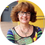
Sisi Zlatanova |
|
Professor
|
||
3D indoor modelling. Challenges and opportunitiesAbstract: Research in support of indoor mapping and modelling (IMM) has been active for over thirty years. This research has come in the form of As-Built surveys, Data structuring, Visualisation techniques, Navigation models and so forth. Much of this research is founded on advancements in photogrammetry, computer vision and image analysis, computer graphics, robotics, laser scanning and many others. While IMM is used to be the privy of engineers, planners, consultants, contractors, and designers, this is no longer the case as commercial enterprises and individuals are also beginning to apply indoor models for navigation and facility management or Smart Cities and Digital twins. During the presentation challenges and opportunities related to IMM and the users will be shared and discussed. Bio: Sisi Zlatanova is a professor and head of GRID at the Faculty of Built Environment, UNSW Sydney. Sisi has been conducting research in many aspects of 3D geoinformation: data representation, structuring, analysis and BIM/GIS integration. Her recent research concentrates on 3D Indoor modelling and navigation. She is author and co-author of more than 400 papers and 23 books. She has been involved in the work of several internationa organisations. She is the president of ISPRS TC IV on Spatial Information science, the treasurer of UDMS and a co-chair of OGC SWG IndoorGML. |
||
 |
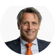
Frank Tierolff |
|
Chairman
|
||
Use and applications of new technologiesAbstract - TBA Bio: Frank is the new chairman of the Executive Board of the Netherlands’ Cadastre, Land Registry and Mapping Agency, in short: Kadaster. His focus is to position and represent Kadaster at national and international level. Main areas of responsibility are Strategy and Policy, Finance and Governance, Human Resources and Facility Management. He is a promoter of Kadaster as a partner in the GEO sector and emphasizes the relevance of innovation. Frank is a strong ambassador of partnerships between the academic, private and public sector. After studying Dutch Law in Maastricht, he started his career in the banking sector. Shortly afterwards, he continued his career at Kadaster as policy and legal advisor. Since 2006, Frank has held several senior management positions. Prior to his recent role as chair, he was a member of the Executive Board for 5 years and responsible for landregistry, surveying, landreform, mapping and ICT. Before 2014, Frank held several positions as member of the executive board (core business, IT) at head office and branch offices. |
||
Plenary Session 2 - Integraded Land and Water Management |
||
 |
Nick van de Giesen |
|
Professor
|
||
New observational methods for water, weather and climate in Africa with results from the TWIGA ProjectAbstract: Africa lacks behind most of the rest of the world when it comes to environmental observations. Only about sixty meteorological stations deliver operational data that are fed into forecast systems. No wonder that rainfall predictions for tomorrow in most of Africa are about as (un)reliable as ten day forecasts in Europe. The good news is that new sensors, cheap electronics, and extensive cell phone coverage could very well facilitate an environmental observation revolution in Africa. The European TWIGA project (www.twiga-h2020.eu) tries to accomplish exactly that. Here, some examples are presented that may be of interest to a broader public. For example, GPS/GNSS receivers for consumers have much improved over the past years as a result of the quest for self-driving cars. These receivers now use two frequencies, which was previously only done by expensive geodetic stations. We use these receivers to estimate atmospheric water content with near-millimeter accuracy and to make accurate flood hazard maps. Although no panacea for the continent’s massive challenges, these and similar instruments will support sustainable development of its human and natural resources. Bio: Nick van de Giesen received the Kandidaats (B.Sc.) and M.Sc. degree in land and water management from Wageningen Agricultural University, Wageningen, The Netherlands, in 1984 and 1987, and the Ph.D. degree in agricultural and biological engineering from Cornell University, Ithaca, NY, in 1994. After a postdoctoral position with the West Africa Rice Development Association, Bouaké, Côte d’Ivoire, he was a Senior Researcher for six years with the Center for Development Research (ZEF), Bonn, Germany. Since 2004, he holds the “Van Kuffeler” Chair of Water Resources Engineering at Delft University of Technology, Netherlands. He is chairman of the Delft Global Initiative, co-director of the Trans-African Hydro-Meteorological Observatory (www.tahmo.org), and member of several international scientific advisory boards. |
||
 |
Gordana Jakovljovic
| |
Young Surveyor,
Ph.D Student
| ||
Mapping plastic – the step forward for a cleaner environment.Abstract: More than 8 million tonnes of plastics end up in the ocean each year. Land-based sources are considered the dominant input of plastics, especially, rivers draining areas with high population density and industrial development represents kay enter point of plastics debris to the ocean. Although marine debris has become a significant concern for the health of ocean and humans there are many questions about sources, pathways, and trends in abundance of marine plastic. This presentation will examine the developed methodology and results of the identification of floating plastic by using remote sensing and geospatial technologies. Produced maps should be used as a base for the creation of action plans for removing plastic from the environment. Bio: Gordana Jakovljević is currently employed as a teaching assistant in the field of remote sensing and cartography at Faculty of Architecture Civil engineering and Geodesy, University of Banja Luka. She is a Ph.D. student and she finalizes the preparation of her thesis. Her practical and theoretical research deals with the application of remote sensing technology in the field of environment protection, especially in water management. She published several papers in journals and scientific conferences proceedings and she was involved in international and national projects. She is a member of FIG commission 4 (Hydrology) and working group 4.3 – mapping plastics. |
||
Plenary Session 3 - Ten years to achieve the SDG's |
||
 |
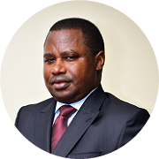
Emmanuel Nkurunziza |
|
Director General
|
||
Land RegularizationAbstract - TBA Bio - Dr. Emmanuel Nkurunziza is the Director General of Regional Centre for Mapping of Resources for Development (RCMRD) – an intergovernmental organization with 20 contracting Member States in Eastern and Southern Africa. He took up this position early this year after an 8 year tenure as the Director General of Rwanda Natural Resources Authority, a position he held concurrently with that of Chief Registrar of Land Titles. Dr. Nkurunziza provided the technical and strategic direction to the development and implementation of Rwanda's land reform programme that managed to bring all land in the country under registered title and established a modern land administration system. The titling programme in Rwanda pioneered full-scale implementation of what are now generally referred as fit-for-purpose land administration techniques and approaches. Dr. Nkurunziza's academic background is in Land Surveying but holds a masters degree in Urban planning from the University of Wales (Cardiff) and PhD in Public Policy from the University of Birmingham (UK). He began his career in the academia, having worked in various roles as Research Fellow and Lecturer in the Universities of Makerere (Uganda) and Birmingham (UK). He has undertaken research and published on urban land delivery systems as well as livelihoods. |
||
 |
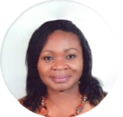
Janet Edeme |
|
Head
Rural Economy Division in the Department of Rural Economy and
Agriculture
|
||
Realizing Agenda 2063 and the Sustainable Development Goals Through Improved Land Governance SystemsAbstract - The African Union (AU) Agenda 2063 and the Sustainable Development Goals (SDGs) provide key aspirations for African Union Member States to achieve meaningful economic growth while safeguarding the environment and promoting the well-being of the African citizenry. The nexus of land, water and the surveying profession continues to play a key role in all aspects of development. Surveyors therefore have a critical role in establishing robust land governance by ensuring that the highest of standards and ethics are adhered to in the delivery of their work. However, the challenge still remains to ensure that the services of surveyors can reach the greater masses, particularly the poor. As we approach the last decade of working towards attaining various SDG targets, we have to reflect on what has been realized so far and clearly articulate the challenges that lie ahead of us putting in mind the role of the surveyor in achieving the SDGs and the AU Agenda 2063. Bio - Dr. Janet Edeme is presently the Head, Rural Economy Division in the Department of Rural Economy and Agriculture of the African Union Commission in Addis Ababa, Ethiopia. Within the African Union Department of Rural Economy and Agriculture, she is the focal point following up on the status of implementation of initiatives and programmes adopted by the AU Heads of State and Government, such as The AU Declaration on Land through the Land Policy Initiative which is now the African Land Policy Centre, The Continental Agribusiness Strategy, Continental Strategy on Post-Harvest Management, Policy Framework on Pastoralism to name a few. She also chairs a number of committees within the Commission and externally such as the Advisory Group of the Agricultural Policy Research in Africa (APRA) led by the Future Agricultures Consortium, she is a member of the Board of Directors of the Forum for Agricultural Research in Africa (FARA) and also a member of the Project Steering Committee of the Technology for African Agricultural Transformation (TAAT) programme of the African Development Bank. |
||
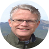 |
Menno-Jan Kraak |
|
Professor
|
Abstract - The United Nations identified seventeen Sustainable Development Goals to collectively address the most pressing problems facing our world in relation to social, economic and environmental challenges. Each SDG has a set of targets and indicators to assess progress across countries.
To achieve the goals, we need to understand each challenge and be able to monitor progress towards alleviating it. Well-designed maps and diagrams can assist in this process because they effectively reveal spatio-temporal patterns, such as deforestation, and the environmental and social challenges resulting from it. Maps can support decision-making by local and national authorities as well as promote public awareness of global issues to encourage these authorities to act.
However, many of the maps and diagrams about the SDG indicators are produced without awareness of established cartographic design guidelines. Flawed and misleading designs often result. Problems also regularly originate from inappropriate data-handling, distracting base maps, inappropriate map elements, and the (mis)use of software defaults. The presentation will demonstrate these problems and discuss the challenges face to avoid them.
Bio - Menno-Jan Kraak is professor of Geovisual Analytics and Cartography at the University of Twente / ITC. Currently he is head of ITC’s Geo-Information Processing Department. He was President of the International Cartographic Association (ICA) for the period 2015-2019, and currently the immediate past president, and chair of the UN-GGIM Geospatial Societies. He wrote more than 200 publications, among them the books ‘Cartography, visualization of geospatial data’ (with Ormeling), and 'Mapping time’. Menno-Jan is chair of the Foundation Scientific Atlas of the Netherlands, and member of the editorial board of several international journals in the field of Cartography and GIScience. https://research.utwente.nl/en/persons/menno-jan-kraak https://blog.utwente.nl/kraak/
 #FIG2020 |