"A simple inspection of
still-existing Roman roads, aqueducts and canals
shows that the Romans were exceptionally skilled
engineers. Shoe sizes provide a person’s shoe
fitting size. There are many different shoe-size
systems used in the world today. Wi-Fi is a family
of wireless networking technologies, commonly used
for local area networking of devices and Internet
access.
But what do Roman roads, shoe
sizes and Wi-Fi have to do with surveying
and indeed
FIG?
Surprisingly they have a lot in common…"
Standards have existed for thousands of years. The first long
distance roads in Europe were built by Imperial Rome. The chariots
made ruts that became a de-facto standard for all other wagons and
later was the gauge for laying the first railway lines. Modern
standards have evolved to cover all aspects of our lives, from shoe
sizes and screw threads, to the Wi-Fi networks that connect us to
each other.
Standards ensure that customers and consumers can have
confidence that the products and services they use are safe,
reliable and of good quality.
Surveyors are deeply influenced by and involved with standards.
FIG contributes to two International Standards Organisation (ISO)
Technical Committees. The first, ISO/TC211
Geographic information/Geomatics has more than 100 standards
associated with location on the Earth. The second,
ISO/TC 172 SC6 Survey Instrument Standards, provides a
comprehensive coverage of surveying instruments standards. FIG also
contributes to non-ISO standards related to surveying (IMLS, IPMS,
ICMS, Hydrography …).
Read more in the GeoConnexion article
Progress reports
Progress reports from FIG Standards Network at FIG General
Assemblies:
This network sees itself as at the hub of FIG
standardisation activity, making the necessary linkages
and providing the necessary advice to commissions and
others. The terms of reference of the Network set out in
the
FIG Guide on Standardisation are:
Building and maintaining relations with the
secretariats of standardisation bodies,
Proposing priorities on FIG’s standardisation
activities, including advising the Council on
priorities for spending,
Setting up necessary Liaison relationships with
standardisation bodies,
Ensuring that lead contacts to Technical
Committees etc. are in place,
Maintaining an information flow on
standardisation to FIG members, including through
the FIG website, and more directly to relevant
Commission Officers,
Maintaining the
Standards Guide, and related
material on the FIG website,
Working with other NGOs, within the framework of
the MOUs signed by the Council,
Advising FIG’s officers and members on
standardisation activities as necessary.
What standards are FIG involved in?
ISO/TC211 Geographic
information/Geomatics
ISO/TC211 is involved with Standardization in the field of
digital geographic information. It aims to establish a
structured set of standards for information concerning objects
or phenomena that are directly or indirectly associated with a
location relative to the Earth. These standards may specify, for
geographic information, methods, tools and services for data
management (including definition and description), acquiring,
processing, analyzing, accessing, presenting and transferring
such data in digital/electronic form between different users,
systems and locations. The work links to appropriate standards
for information technology and data where possible, and provides
a framework for the development of sector-specific applications
using geographic data.
More
ISO 19152:2012 Land Administration Domain Model
(LADM)
The standard provides a
formal language for describing traditional land
administration methods, spot the similarities and
differences. This Standard grew out of the Commission 7
work on the Core Cadastral Domain Model. It was accepted
into the ISO/TC 211 work programme in 2008. It
facilitates the efficient set-up of land administration
and can function as the core of any land administration
system. LADM is flexible, widely applicable and
functions as a central source of state-of-the-art
international knowledge on this topic. LADM is of one of
the first spatial domain standards. More
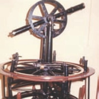
ISO/TC 172 SC6 Survey
Instrument Standards
ISO/TC 172 SC6 provides a
comprehensive coverage of standards related to surveying
instruments and their accessories including: handheld
laser distance meters, levels, theodolites, EDM
measurements to reflectors, total stations, GNSS field
measurement systems in real-time kinematic (RTK),
terrestrial laser scanners etc.
More
ISO 12858 Series
Ancillary Devices for Geodetic Instruments
ISO 16331 Series Laboratory Procedures for
Testing Surveying and Construction Instruments
ISO 17123 Field Procedures for Testing Geodetic and
Surveying Instruments
ISO 9849 Series Geodetic and Surveying Instruments
International Property Measurement
Standards Coalition (IPMS)
At present, the way property
assets – such as homes, offices or shopping centres –
are measured varies dramatically. For example, in some
parts of the world it is established practice to include
common space (lift shafts; communal hallways etc) in
floor area measurements; in others off-site parking
might be included or even swimming pools.
The International Property
Measurement Standards Coalition (IPMSC) is an
international group of professional and not-for-profit
organisations working together to develop and embed a
single property measurement standard. A Standard will
ensure that property assets are measured in a consistent
way, creating a more transparent marketplace, greater
public trust, stronger investor confidence, and
increased market stability. More
International Land Measurement
Standard (ILMS)
The International Land
Measurement Standard (ILMS) is an international
principle-based standard for recording and reporting
information and material relevant to land and property
transfers.
ILMS is a due diligence
framework and standard for land and real property
surveying that supports a sustainable future both for
people and legal entities. ILMS is both a standard and a
due diligence framework to enable evidence-based
assessment of land and property and is designed to
address the current lack of transparency in land rights
and land interests. ILMS recognises gender equality and
pro-poor issues when gathering field information on
legitimate land ownership and is also deeply connected
and complimentary to other globally relevant standard
and frameworks in the land acquisition and transaction
space. More
International Construction Measurement
Standards (ICMS)
ICMS is a global standard
for benchmarking and reporting of construction project
cost and covers both capital and whole life costing
while providing a way of presenting costs in a
consistent format.
Research from the World
Economic Forum has shown that improvements in the design
and construction process can be achieved by using
international standards like ICMS to gain comparable and
consistent data. ICMS provides a high-level structure
and format for classifying, defining, measuring,
recording, analysing and presenting construction and
other life-cycle costs.
This will promote
consistency and transparency across international
boundaries, which in turn will lead to more confidence
to increase global investment in construction projects.
More
Standards in Hydrography
FIG Commission 4’s
involvement with the update of IHO Document S-44
Standards of Hydrography is now complete. We have
reviewed and analysed initial user feedback, contributed
technical expertise and advice to the S-44 Working Group
and provided feedback on some of the new chapters. The
Working Group has submitted the draft to the IHO and it
is (or shortly will be) out for member state
consultation
WG4.1 is also
an advisory member of the S-100 WG. Through this work
cycle, WG 4.1 will be focussing on hydrographic surveyor
competency through the active promotion of certification
and assessment as well as offering assistance, advice
and guidance on hydrographic standards as
requested/required by IHO and other bodies.
More
Surveyors as professionals must fulfil certain
legal, regulatory and/or accuracy requirements for their
clients. Typically, they will strive to do this in an
optimal cost effective way and with the most appropriate
equipment for the job at hand. Naturally, this requires
a good understanding and assurance in the
instrumentation employed. Clients and customers want the
most from what they pay for. Legislative authorities as
well as private and public companies require confidence
that the services rendered are in conformity with
globally accepted best practice rules.
Using internationally recognized standards is a
widely accepted way of fulfilling these requirements.
FIG supports and promotes Standardisation through the
Standards Network.
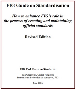
FIG Publication 28a:
FIG GUIDE ON STANDARDISATION
How to enhance FIG’s role in
the process of creating and maintaining official
standards
Purpose of this guide
This guide was created by the FIG Task Force on
Standards, and has been updated by the FIG Standards
Network, to assist the FIG Council, Commissions and
Member Associations in their efforts to make a
difference in standardisation activities.
Standardisation activities can often seem complex or
even impenetrable, and the Task Force and Network have
seen one of their prime roles as filtering important
information about standardisation activities and
explaining how surveyors can be actively engaged in the
processes.
The FIG Standard Network started as a
task force. The Task Force was established in 1998 in response to
concerns from the Commissions, the Council and the General Assembly that
standards were becoming increasingly important in the work of surveyors, and
that the issue was not being addressed sufficiently by FIG. The Task Force's
work plan continues to develop as priorities become clearer.
The the Working Week in Washington, DC., USA in 2002, the Council
decided to disband the Task Force and continue the work on standards in FIG by a
Standardisation Network.