News in 2013
|
10th United Nations Regional Cartographic Conference for the
Americas
New York, United States, 19 - 23 August 2013
The 10th United Nations Regional Cartographic Conference
for the Americas was held from 19 – 23 August 2013 at the UN headquarters in
New York with the theme “UN-GGIM and the Americas: Addressing global
challenges through geospatial information”. UNRCC-Americas provides a
regional forum to address their common challenges and share experiences and
expertise in the field of surveying and mapping, cartography, hydrography,
remote sensing, land and geospatial information systems.
The conference was opened by Mr. Luiz Paulo Fortes
of Brazil together with an opening Statement by the Acting Director of the
Statistics Division, Department of Economic and Social Affairs of the United
Nations, Mr. Stefan Schweinfest. The opening session was followed by
the first plenary session concerned with administrative formalities where
Mr. Rolando Ocampo Alcantar of Mexico was elected President of the
Conference. The two elected Vice Presidents were Ms. Paula McLeod of
Canada and Mr. Juan Antonio Nieto Escalante of Columbia. Duane
Miller of the Bahamas was elected the Rapporteur. The Conference
reported on the implementation of the resolutions of the 9th Conference as
well as the activities and work of the Permanent Committee for Geospatial
Data Infrastructure of the Americas (PC-IDEA).

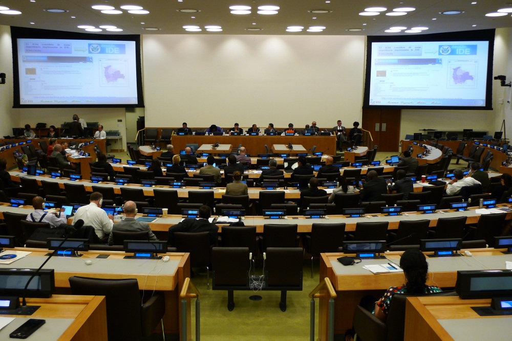
10th United Nations Regional Cartographic Conference for the Americas in
session
The Conference established three technical committees as
well as elected the respective chairperson. The three committees are-
-
UNRCC-A Technical Committee I
United Nations Initiative on Global Geospatial Information Management
and the Americas: Strategic, Policy, Economic and Institutional Issues
Chairperson: Mr. Ronaldo Ocampo Alcantar of Mexico
-
UNRCC-A Technical Committee II
Spatially Enabling Government Through Geospatial Data Collection,
Management and Dissemination
Chairperson: Mr. Luis Paulo Fortes of Brazil
-
UNRCC-A Technical Committee III
Best Practices and Applications, including Climate Change and Disaster
Risk Management
Chairperson: Mr. Ronald Jackson (Jamaica)
94 participants from 29 UN Member States attended the
Conference and included regional and international organizations. The
President represented FIG who also met and had discussion on matters of
mutual interest with Mr. Santiago Borrero, the Secretary General of
the Pan American Institute of Geography and History (PAIGH). PAIGH and FIG
have a Memorandum of Understanding for collaborative activities.
The technical conference covered various thematic tracks
including Global Geospatial Information Management: Strategy, Policy,
Economic and Institutional issues; Spatially Enabling Government; Geospatial
data collection, management and dissemination and Climate change and
disaster risk reduction. FIG contributed with a presentation on Spatially
Enabled Society, informing the Conference on its work on Spatially Enabled
Society and by Society FIG does include Government. The presentation
considered current drivers and key elements in spatially enabling society
and observed some challenges and opportunities ahead.
Click
here
for the full presentation.
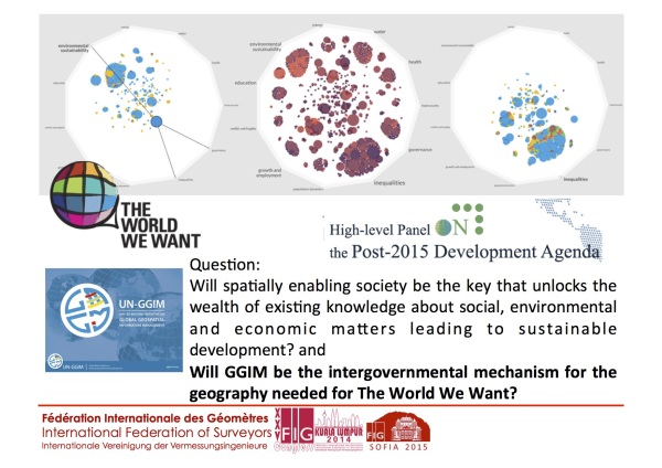
In the
presentation,
FIG observed an opportunity to link spatially enabling society with the
Post-2015 Development Agenda. Recognizing that the Agenda will be the bold,
engaging and inclusive global political agenda with universal goals and
national targets, and it is on our horizon, the question posed to the
Conference is whether geospatial information, the managing of all
information spatially and thus spatial enablement can be the key that
unlocks the wealth of existing knowledge about social, environmental and
economic matters leading to sustainable development and will GGIM be the
intergovernmental mechanism for the geography needed for “The World We
Want”?
The 11th United Nations Regional Cartographic Conference
will be held in 2016.
CheeHai TEO
September 2013
10 October 2013
|