News in 2016

|
Report from the 5th session of UNGGIM
3-7 August 2015, New York, United States
The Fifth Session of the United Nations Committee of Experts on
Global Geospatial Information Management (UN-GGIM) was held in NY, 3-7
August 2015. The session was attended by 290 participants (216
representatives from 85 Member States, 7 from 1 non-Member State, 67
from organizations of the United Nations and observers for
intergovernmental, non-governmental and other organizations). FIG
President participated in that event. The Co-Chair of the
Committee, Vanessa Lawrence CB opened the session.
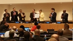
During the opening session, the Committee of Experts congratulated Dr
Vanessa Lawrence CB for her achievements and the
Under-Secretary-General of the Department of Economic and Social Affairs
(DESA), Mr. Wu Hongbo awarded her a certificate of
appreciation. The committee then elected the following new
officers:
Co-Chairs: Tim Trainor (United States of America), Rolando Ocampo
(Mexico), Li Pengde (China)
Rapporteur: Abdoulaye Belem (Burkina Faso)
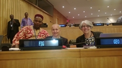
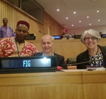
FIG President Chryssy Potsiou attended the meeting |
Dr Vanessa Lawrence
receives the certificate of appreciation |
The global importance of geospatial information was formally
recognised by the United Nations when UN-GGIM was established by the
Economic and Social Council (ECOSOC) in July 2011, recognizing that
there was no global Member State driven mechanism to discuss critical
issues and set directions on the production, management and use of
geospatial information within national and global policy frameworks and
therefore it was an urgent need to take action in order to strengthen
international cooperation in this field. As mentioned in the website (http://ggim.un.org/)
the Committee of Experts is a formal inter-governmental mechanism that
coordinates global geospatial information production and management, and
is composed of government experts from the national geospatial
information authorities from more than 100 United Nations Member States,
as well as experts from relevant international organizations, the
private sector, and other major global stakeholders from the geospatial
information industry and civil society, who participate as observers.
Since 2011 the Committee members have met and worked together at the
annual sessions, the three High Level Forums that have been convened,
and a number of international technical capacity development workshops
and related fora.
The following text is a summary of information formally provided by
UNGGIM, to help newcomers understand this initiative.
The Committee of Experts considered a detailed draft of the review of
the work of the Committee during the 2011-2015 period and noted the
considerable achievements and progress made, as well as the challenges
that remain. With very limited resources but, importantly, with strong
engagement and commitment by Member States and the international
geospatial community, the Committee of Experts has established and
organised itself quickly and delivered concrete results towards
achieving its mandate. Over the past five years the Committee has
produced key tangible outputs that may briefly be summarized as
following:
- Establishment of a working group, in 2011, to elaborate a
detailed inventory of issues and a proposed work plan of actions to
be implemented. The inventory was endorsed in 2012 and included a
number of issues such as: the global geodetic reference frame; the
global map for sustainable development; the adoption and
implementation of international geospatial standards; the
determination of global fundamental datasets; geospatial information
to support the sustainable development goals and the post-2015
development agenda; the development of a knowledge base for
geospatial information; the identification of trends in national
institutional arrangements in geospatial information management; the
integration of geospatial, statistics and other information; the
legal and policy frameworks; the development of a statement of
shared guiding principles; the development of geospatial information
and services for disasters; and land administration and management.
- Establishment of five UN-GGIM regional coordination committees,
in Asia and the Pacific, the Americas, the Arab States, Europe and
Africa, for making joint decisions, setting directions, promoting
common principles, policies, methods, mechanisms and standards for
the interoperability of geospatial data and services, and providing
a platform for the development of effective strategies on how to
build and strengthen national capacity concerning geospatial
information, especially in developing countries, in the context of
the implementation of the 2030 Agenda for Sustainable Development
and the Sendai Framework for Disaster Risk Reduction. A
consolidation of the various inter-governmental geospatial organs
within the UN system is currently taking place (such as: PCGIAP and
PC-IDEA have been renamed as UN-GGIM-AP and UN-GGIM: Americas, in
2012 and 2013, and now report annually to the Committee of Experts;
the UN Regional Cartographic Conferences are no longer required and
there is a proposal that should be removed from the UN calendar,
with their mandates and obligations assumed by the Committee of
Experts; the formal UN Regional Cartographic Conference format is no
longer necessary and its removal from the UN calendar of
conferences and meetings was recommended, with its mandates and
obligations assumed by UN-GGIM and UN-GGIM-AP)
- Organization of annual sessions; three High Level Forums on
Global Geospatial Information Management, in October 2011 in the
Republic of Korea, in February 2013 in Qatar and in October 2014 in
China. The Fourth High Level Forum will be convened in Addis Ababa,
Ethiopia, in April 2016.
- Contribution to increasing the visibility and awareness of
geospatial information, as an essential integrative tool to monitor
and measure sustainable development, to policy and decision-makers
and the diplomatic community.
- Formulation and endorsement of a resolution on ‘A Global
Geodetic Reference Frame for Sustainable Development’ in a landmark
decision by the General Assembly on 26 February 2015. The resolution
calls for greater multilateral cooperation on geodesy, including the
open sharing of geospatial data, further capacity-building in
developing countries and the creation of international standards and
conventions, and outlines the value of ground-based observations and
remote satellite sensing when tracking changes in populations, ice
caps, oceans and the atmosphere over time.
- Current development of a road map for the global geodetic
reference frame to ensure that Member States are able to leverage
the importance of geodetic data sharing, methods, sustainable
funding and infrastructure to support growing societal needs,
including those monitoring progress towards the sustainable
development goals.
- Endorsement in 2013, of the strategic report “Future trends in
geospatial information management: the five to ten year vision”;
available in eight languages it serves as a technical guide for
Member States in the preparation of their national geospatial
information strategies and plans. The Future Trends report was
reviewed, updated and ratified by the Committee at its fifth session
in 2015.
- Adoption in 2015, of the ‘Guide to the Role of Standards in
Geospatial Information Management’ and the ‘Companion Document on
Standards Recommendations by Tier’ as the international geospatial
standards best practice for spatial data infrastructures. Documents
are being translated into the official UN languages with the support
of relevant Member States.
- Initiation of regional capacity building projects, such as the
one led by the National Administration of Surveying, Mapping and
Geoinformation (NASG) and the UN-GGIM Secretariat titled ‘Geospatial
Information Management Capacity Development in China and other
Developing Countries 2013-2017’; the ‘Strengthening of Spatial Data
Infrastructures in Member States and Territories of the Association
of Caribbean States’ project led by the government of Mexico
providing financial and technical support to 19 countries in the
Caribbean region (Caribbean Project); and at global level the
‘Strengthening the geospatial information management capacities of
developing countries for better policy making at national, regional
and international level’ project led by the UN Statistics Division
during the period 2012-2015.
- Establishment of partnerships with international bodies such as
the Group on Earth Observations (GEO), the International Federation
of Surveyors (FIG), the International Cartographic Association
(ICA), Technical Committee 211 of the International Standards
Organisation (ISO/TC 211), the Open Geospatial Consortium (OGC), and
many others
- Development of the “UN-GGIM knowledge base” which provide
information about issues like: the status of national geospatial
information management and systems; global geodetic information
management; the status of mapping in the world; the integration of
geospatial and statistical information; geospatial information
management best practices and case studies in countries; training
manuals; and publications on geospatial information.
- Creation of the Expert Group on the Integration of Statistical
and Geospatial Information, in 2013, composed of national experts
from both the statistical and geospatial communities, to address
“the critical importance of integrating geospatial information with
statistics and socio-economic data and the development of a
geospatial statistical framework, especially in the context of the
on-going debate on the post-2015 development agenda”
At its fifth session, the Committee of Experts among other decided
to:
- Work closely with the statistical community, both at a national
and global level, by providing inputs into the processes to develop
the global indicator framework under the auspices of the
Inter-agency Expert Group on SDG Indicators (IAEG-SDGs), as many
goals have a geospatial dimension. As a means to do so, the
Committee established a task team of Member State geospatial experts
to assist in developing the inputs, building on existing work; the
need to support the Sendai Framework for Disaster Risk Reduction
2015-2030 with the appropriate indicators was emphasized. It was
also stressed that there is a need for resources and strong
commitment of decision-makers for the implementation of the global
indicator framework.
- Encourage Member States and the relevant working group (WG), in
their efforts to develop the road map, to commit to undertaking a
programme of outreach that highlights experiences and best practices
for the global geodetic reference frame, particularly in developing
countries and encouraged the WG to continue its efforts to build on
global and regional experiences and initiatives and to report back
to the Committee of Experts at its next session on its progress
towards delivering the road map
- Support the initiative proposed by the Regional Committee of
United Nations Global Geospatial Information Management for Europe
to lead the working group to liaise with other regional committees
of United Nations Global Geospatial Information Management to bring
together the consideration about the fundamental geospatial data
themes, with a view to developing an agreed minimum set of global
fundamental geospatial data themes, and supported the establishment
of the GlobeLand30 International Advisory Committee.
- Note that the Expert Group for the Integration of
Statistical and Geospatial Information would undertake to develop
the global geospatial-statistical framework for presentation to the
Statistical Commission and the Committee of Experts in 2016.
- Endorse the establishment of an expert group to undertake the
work needed to advance the activities related to land administration
and management, and recommended that the group will collaborate with
other relevant professional bodies and experts working in the field
to avoid duplication of work. It also approved and supported the
convening of the fourth High-Level Forum on Global Geospatial
Information Management, to be held in Addis Ababa 20-22 of April
2016, with a focus on land administration and management, and with a
particular emphasis on sharing experiences, including benefits and
challenges, considering “fit-for-purpose” aspects, digital land
registers, cadastres, and other land data needs, demonstrating
practical examples of land administration success stories.
- Encourage the WG on the trends in national institutional
arrangements in geospatial information management to continue its
work and improve collaborations to avoid duplication of work and
report in the next session.
- Discuss recent developments in legal and policy frameworks,
including issues related to authoritative data, and also noted that
the geospatial community now needed to be more proactively engaged
with issues relating to the collection, use, privacy, provenance
and, accessibility of data, as well as issues related to the use of
unmanned aircraft systems (drones) and other potentially intrusive
devices; a relevant conference will be planned within 2016.
- Adopt the final published “Guide to the role of standards in
geospatial information management” and the “Technical compendium” as
the international geospatial standards best practice for spatial
data infrastructure, and encouraged all Member States to adopt and
implement the recommended standards.
- Take note of the report on the coordination of United Nations
activities related to geospatial information management and
encouraged the continuation of efforts.
- Note the announcement of the completion of the report on the
status of topographic mapping in the world by the International
Society for Photogrammetry and Remote Sensing and the proposal to
establish a working group for possible future maintenance
- Request that the document entitled “Future trends in geospatial
information management: the five to ten year vision, Second Edition”
will be finalized in 2016, and encouraged Member States to continue
to contribute to the knowledge base portal.
- Propose to stage a map exhibition, focusing on sustainable
development, in August 2016 during the sixth session of the
Committee
- Welcome the Economic Commission for Africa as the secretariat of
the Regional Committee for Africa
- Note the efforts of the Arctic Spatial Data Infrastructure in
delivering regional data and the need to ensure continued
cooperative efforts to support science and decision-making
- Adopt the agenda for its sixth session and decided to recommend
to the Economic and Social Council that its sixth session be held at
United Nations Headquarters in New York from 3 to 5 August 2016
In her statement to UN-GGIM, FIG President Chryssy Potsiou
congratulated the UN-GGIM and the member countries
for including land administration to the UN-GGIM agenda. She stated that
FIG believes this is a major step towards achieving the post 2015
development goals. She further stated that, although we all live in the
era of a globalised economy, not all citizen of this world experience
the benefits of inclusive and efficient land administration that
provides transparency in the management of land and the necessary
infrastructure to the people, especially the low-income earners, to
acquire access to capital, to improve their living standards and to
protect the planet. FIG strongly believes in the land administration
concept and has already developed long activity, in-depth research,
international cooperation with FAO and the WB and a series of
publications in this field. FIG declares its strong commitment to
continue its cooperation with the UN-GGIM in this field and to build
upon the existing experience and knowledge, avoid any dublication of
efforts, avoid any time delays, and work closely, hand in hand with the
countries, in an joint mission to translate these words into action.
At this critical stage in the global development cycle, Member States
have specified that they seek to further expand the mandates of the
Committee to enable it to function as the global governing body on all
issues related to geospatial information in order to effectively and
efficiently support the emerging geospatial demands for Member States
and global agenda such as the 2030 Agenda for Sustainable Development.
Chryssy Potsiou
06 January 2016