Article of the Month -
September 2024
|

Application of UAV-based Photogrammetry
in Monitoring Slope Deformations in Open Pit Mining Environments: A
Systematic Review
Janet Praise Tangadzani, Charles Paradzayi
And Tanaka Grey Muromo Zimbabwe
This article in .pdf-format
(12 pages)
This paper was awarded the NavXperience AWARD and
was presented during the FIG Working Week 2024 in Accra, Ghana.
SUMMARY
Mine surveyors play a critical role in assessing and monitoring slope
deformations in open pit mining environments. Monitoring the stability
and deformation of open pit slopes is crucial to minimize hazards at
mining sites. However, traditional survey methods for monitoring slope
deformations, such as precise levelling, total station surveys, and GNSS
surveys, can be limited in terms of coverage as the pit advances,
accessibility, and safety of the survey crew. Unoccupied Aerial Vehicle
(UAV) based photogrammetry is an emerging technology that is gaining
prominence in monitoring open pit slope deformations. The review aims to
summarise the current knowledge, perspectives and potential areas for
future exploration of this emerging monitoring methodology for open pit
mines. The research used "Preferred Reporting Items for Systematic
Review and Meta-Analysis": the keywords used were "mine”, “slope" and
"photogrammetry") combined with the words "open pit", "temporal
analysis", "UAV" and “deformation monitoring” and applied to the most
appropriate databases. 47 records were initially identified; after
applying exclusion criteria (such as year, document type, source type,
language) and after an initial review of each study title, 30 articles
were considered eligible. Records were examined in full text to obtain
the required information, leaving only 24 records. Most studies utilized
photogrammetric techniques (using unoccupied aerial vehicles) to monitor
open pit slope deformations. There is need to conduct more research on
the temporal problems that were identified in the review. Addressing
this research gap will lead to effective and robust harnessing of
UAV-based photogrammetry in monitoring slope deformations in open pit
mining operations.
1. INTRODUCTION
Slope collapses are triggered by factors such as local
geological conditions and mining activities (Salvini et al.,
2018). Hazardous situations may arise when unfavourable
sedimentological characteristics and geological
discontinuities are made more critical by resource
extraction (Zajc et al., 2014). Morphological features like
sharp cuts and steep slopes also play a crucial role in
triggering rockfalls in mining areas (Zheng et al., 2015).
In order to assess the possibility of slope failures, it is
crucial to understand the geometric links between geological
discontinuities and slope morphology (Salvini et al., 2018).
Photogrammetry analyses images from multiple viewpoints,
allowing for the calculation of the three-dimensional
coordinates of the points (Poudel, 2023). This allows for
the detection of any irregularities or changes in the
surface of the object being measured (Ozhygen et al., 2021).
The impact of mining and expansion of the mining area leads
to the opening and formation of new rock joint blocks, which
weakens the stability of the slopes (Ozyhygin et al., 2021).
Slope monitoring is a critical process for assessing the
stability of natural and man-made slopes to ensure the
safety of people and infrastructure located on or near them
(Poudel, 2023). The accuracy, cost and convenience of
monitoring are primarily determined by the monitoring method
used (Li et al., 2021). The above studies noted that
traditional slope deformation monitoring mainly includes
point monitoring and surface monitoring. Total stations,
levels and Global Navigation Satellite System (GNSS) are
commonly used in point monitoring (Li et al., 2021).
However, these point-based monitoring techniques provide
limited spatial coverage and often require time consuming
fieldwork for data collection (Li et al., 2021; Bar et al,
2020). For example, Bar et al. (2020) noted that by
utilising traverse procedures, traditional rock slope
mapping techniques would normally require 30 to 180 minutes
of field time to evaluate a 10-metre length of slope.
Giordan et al. (2020) noted that the use of unmanned aerial
vehicles (UAVs) has grown rapidly, and it is now thought of
as a standard research tool for the on-demand capture of
images and other information over a given area of interest.
UAV refers to an unmanned aerial vehicle that can fly
autonomously with or without an engine, can be operated
remotely, and can gather data (Giordon et al., 2020). Coccia
et al. (2022) agreed that a UAV is remotely operated,
semi-autonomous, autonomous or a combination of these
capabilities.
The foundation of photogrammetry technology is to capture an
actual thing in a series of photographs taken from various
perspectives and to analyse the images collected using
specialized software that independently connects the images
together to establish the framework for a three-dimensional
object (Ozyhygin et al., 2021). The last decade has
witnessed unprecedented growth in the use of UAVs in open
pit slope deformation monitoring (Battulwar et al., 2020).
The study added that UAV technology is the ideal tool to use
in these tasks, given the size of mines and their hazardous
environment. By using overlapping photos captured by aerial
cameras, photogrammetry reconstructs three-dimensional (3D)
representations of slope surfaces (Poudel, 2023).
Using UAVs equipped with cameras, photogrammetry allows for
the generation of dense 3D point clouds which can be used
for change detection to monitor mining slope deformations
from imagery (Poudel, 2023). The precise information about
the surfaces that were stabilised and those that are
continuously in danger of deformation may be obtained from
an assessment of the spatial and temporal evolution of the
displacements (Dobos et al., 2022). The study further noted
that it was possible to forecast the spatial and temporal
trends of the deformation.
During the last decade, open pit mines have embraced the use
of UAV-based photogrammetry for slope deformation
monitoring, and arguably it has proven to be more efficient
than traditional surveying methods (Li et al., 2021; Bar et
al., 2020; Kolapo et al., 2022; Battulwar et al., 2021).
There appears to be a paucity of literature on the use of
UAV-based photogrammetry in monitoring open pit slope
deformations. There are few published references that deal
with the research of rock slopes (Francioni et al., 2015;
Coggan et al., 2007; Harbrink etal., 2008; Niethammer et
al., 2010). Furthermore, there is need to study the
feasibility of using photogrammetry for monitoring lateral
movement of slopes (Poudel, 2023). Further research is also
needed to develop methods for optimizing the temporal
frequency and timing of image acquisition for open pit slope
deformation monitoring since available research publications
point to slopes which are monitored on a monthly and
quarterly basis (Francioni et al., 2015; Bar et al., 2020;
Kim et al., 2023; Poudel, 2023; Coccia et al., 2022;
Vinielles et al., 2022).
The current study aims to analyse the research published on
the use of photogrammetry for open pit slope deformation
monitoring. The study searched the literature, which allowed
the authors to understand the use of UAV-based
photogrammetry to effectively monitor slope deformations in
open pit mining environments. The literature also reviewed
the methods used by past researchers to adopt UAV-based
photogrammetry in open pit slope deformation monitoring. The
literature was mapped to understand what lessons can be
learned from the past and discuss a possible future scenario
for monitoring slopes in open pit mines.
2. METHODS
The Preferred Reporting Items for Systematic Reviews and
Meta-Analyses (PRISMA) was used in order to draw up the
scoping review protocol for this study (Tricco et al.,
2018), including the formulation of review questions, search
strategy, study selection criteria, data extraction and
synthesis.
2.1 Eligibility criteria
The scoping review included research articles, official
reports, theses, and dissertations that examined the
outcomes associated with utilising UAV-based photogrammetry
for monitoring open pit slope deformation or similar tasks.
Non-research articles (opinion articles, literature reviews)
and studies that do not specify the use of UAV-based
photogrammetry in open pit slope deformation monitoring were
not considered.
2.2 Search strategy
A search of literature from 2014 to 2023 was performed. The
research included some leading engineering databases: Scopus
and Google Scholar. The keywords defined to conduct the
study are mine, slope and deformation which were
sequentially combined with open pit, UAV and temporal
analysis. All of these keywords were separated by the
boolean operator “AND”. The search was conducted in English.
At the end of this process, the existence of potentially
associated keywords related to the subject in the selected
items was checked. If found, the new keywords were used in
new search combinations with the keywords previously used.
2.3 Selection of sources of evidence
After applying the first set of exclusion criteria, the
review process was divided into two levels of screening. A
detailed review of titles and abstracts was used to exclude
articles that fell out of scope. The second level involved
full-text reviews. For the second level, some minimum
inclusion criteria were applied in order to determine which
papers were to be screened. The respective references of the
selected articles were checked in order to find older
articles not detected in the initial survey. In this
process, the other works of the authors of the selected
articles, as well as the respective research centres, were
verified.
2.4 Data extraction
In the data extraction phase, 24 original articles, review
and conference papers, published reports and case studies
were selected and extracted. The articles were in English
and from the fields of Photogrammetry, Mining and Rock
Mechanics, Geotechnical Engineering. Figure 1 outlines the
systematic literature review approach as adapted from Moher
et al. (2009).
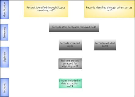
Figure 1: Structure and workflow of the scoping literature
review (adapted from Moher et al., 2009)
3. Results and analysis
The search yielded a total of 47 studies. After screening
the titles and abstracts, 30 studies were identified as
potentially relevant. After a full-text review, 24 studies
met the inclusion criteria and were included in the review
(Figure 2).
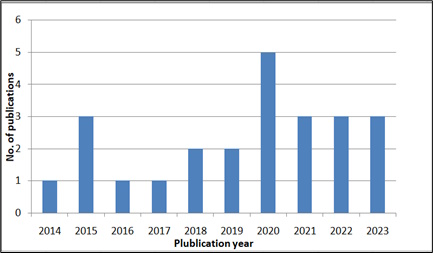
Figure 2: Publication year from the databases
Most of the reviewed publications focused on monitoring
slope deformations and blasting operations in the mining
sector. Other areas included safety inspections, stockpile
inventories, exploration surveys, among others as indicated
in Figure 3.
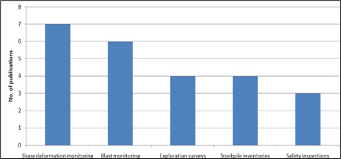
Figure 3: UAV application areas in open pit mining
environments
A number of publications noted the increased use of
quadcopter, fixed wing drone, octocopter platforms in aerial
photogrammetry operations (Bar et al, 2020; Coccia et al.,
2022; Vinielles et al., 2022). Figure 4 shows the types of
UAV platforms which have gained prominence in recent times.
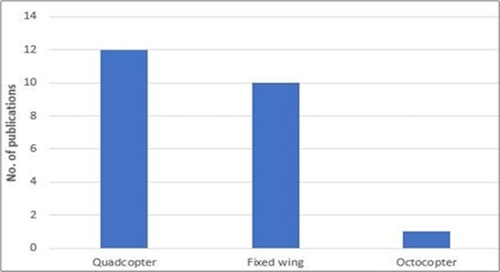
Figure 4: UAV platforms
The reviewed studies found that RGB sensors were the most
commonly used sensors (Francioni et al., 2015).
Multispectral sensors were widely used in slope deformation
monitoring due to their usefulness in mapping steep
environments (Battulwar et al., 2020), while the application
of hyperspectral and thermal cameras was limited as shown in
Figure 5.
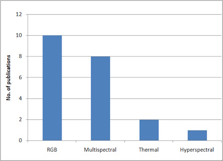
Figure 5: Common UAV Sensors
In recent studies, there has been a trend in the change of the
acronym from unmanned aircraft vehicle UAV to unoccupied aircraft
vehicle UAV. Giordan (et al., 2020) introduced the definition of the
unoccupied aircraft vehicle, and subsequent studies, such as those by
Kim et al. in 2023 and Vinielles et al. in 2022, have adopted this
terminology.
Aerial photogrammetry requires ground control points (GCP) data to
define the mapping datum and image scale and also to ensure a good image
block geometry (Kim et al., 2023; Li et al., 2020). The reviewed studies
utilized flight planning applications and processing software packages
such as Pix4DCapture Map Pilot App, Autopilot for DJI, AgiSoft PhotoScan
processing software, and Pix4DMapper (Francioni et al., 2015; Bar et
al., 2020; Li et al., 2020; Kim et al., 2023).
The reviewed studies utilized UAV-based photogrammetry to monitor
open pit slope deformations. The technology is becoming a powerful,
accurate, cost effective and reliable tool for monitoring open pit slope
deformations (Francioni et al., 2015; Bar et al., 2020; Kim et al.,
2023; Poudel, 2023; Coccia et al., 2022; Vinielles et al., 2022).
Furthermore, the reviewed studies utilized a range of softwares
including Agisoft, Pix4D and ShapeMetriX for processing the 3D spatial
data.
UAV-based photogrammetry and point cloud processing softwares
determine surface displacements by comparing the variations between the
3D point cloud coordinates or digital elevation models obtained by
periodic flights respectively (Francioni et al., 2015; Bar et al., 2020;
Li et al., 2020; Kim et al., 2023; Poudel, 2023; Coccia et al., 2022;
Vinielles et al., 2022). Horizontal displacements can be investigated
using orthoimages while DEMs are ideal for determining vertical
displacement (Kim et al., 2023; Li et al., 2020; Bar et al., 2020). Kim
et al. (2023) analysed both the vertical and horizontal displacements by
using surface elevation change to a preset baseline surface. Bar et al.
(2020) and Vinielles et al. (2022) used DEM elevation differences to
analyse slope deformations in open pit mines. Some of the studies used
visual inspections combined with the methods mentioned above to analyse
slope deformations in open pit mines (Coccia et al., 2022; Li et al
2021).
Both advantages and limitations for the application of UAV-based
photogrammetry have been identified in the reviewed studies. A sequence
of processing procedures used in Structure from Motion enables the
computation of a complete collection of 3D surface points that are then
merged to create a surface description in a photo-realistic manner (Kim
et al., 2023). Due to the availability of redundant information, lens
distortion and other geometric deviations caused by the camera being
utilized are taken into account while creating the 3D model (Bar et al.,
2020). This means that even inexpensive, off-the-shelf drones can be
used to create 3D models with a high enough level of accuracy (Francioni
et al., 2015; Bar et al., 2020; Li et al., 2020; Kim et al, 2023). It
should be noted, nevertheless, that a photogrammetry application on its
own is still not fully capable of carrying out a ground
characterization. for instance, utilising this method would necessitate
spending physical time in the field when it is safe to do so in order to
evaluate or estimate joint qualities like infilling and intact rock
parameters like strength (Bar et al., 2020). Additionally, slope
deformations may be far from perpendicular to the slope surface, and
other complementary techniques could aid in interpreting the true slope
displacement vectors (Kim et al., 2023; Francioni et al., 2015).
4. TRENDS
4.1 Time lapse monitoring
Time lapse photogrammetry allows for continuous monitoring
of slope deformations over extended periods (Francioni et
al., 2015). By capturing images at regular intervals,
changes in slope morphology and deformation patterns can be
detected, analysed and compared over time (Bar et al.,
2020). This approach provides valuable insights into the
behaviour and stability of open pit slopes.
4.2 Integration with other monitoring techniques
Photogrammetry is being used in conjunction with other
monitoring techniques such as Light Detection and Ranging
and radar-based interferometry synthetic aperture radar to
monitor open pit slope deformations (Kim et al., 2023; Li et
al., 2020; Giordan et al., 2020). These complementary
methods provide different perspectives and data sources to
enhance the understanding of slope deformations and improve
the accuracy of deformation measurements (Li et al., 2020).
Francioni et al. (2015) used UAV photogrammetry and
geographic information system (GIS) to effectively estimate
the ground displacements of open pit slopes.
4.3 Real time kinematic and post processed kinematic
Installing and surveying ground control points (GCPs) can
occasionally be expensive and time-consuming, especially in
challenging terrain. Likewise, in a mining operation where
workers might be exposed to interactions from a safety
standpoint, GCPs may not be feasible with haul trucks and
other mining machinery (Harbrink et al.,2008). In such
scenarios, GNSS data collected while the photos were being
taken can be used to scale and orient 3D models (Bar et al.,
2020). Utilising real-time kinematic (RTK) or post-processed
kinematic (PPK) can further enhance pure GNSS reference by
improving the 3D model's absolute geo-localisation without
the need of GCPs (Poudel, 2023; Bat et al., 2020).
5. RESEARCH GAPS
UAV based photogrammetry offers numerous advantages in
monitoring slope deformations in open pit mining, however
despite its potential, there are still research gaps that
need to be addressed to maximize its reliability. One of the
key research gap pertains to temporal monitoring.
Open pit slope deformation is a dynamic process that occurs
over spatial scales ranging from centimetres to kilometres
and temporal scales from hours to years (Chen et al., 2020).
Effective monitoring of slope stability requires remote
sensing data with high temporal resolutions to capture small
deformations as they develop and progress. However,
available studies monitored open pit slope deformations
annually and bi-annually. These infrequent aerial surveys
tend to miss multiple slope failure events occurring at
short time scales (Francioni et al., 2015; Salvin et al.,
2018; Bar et al., 2020; Li et al., 2020; Kim et al., 2023;
Poudel, 2023; Coccia et al., 2022; Vinielles et al., 2022).
Salvin et al. (2018) monitored slope deformations annually
using UAV-based photogrammetry at an open pit mine in Apuan
Alps marble district in Italy. Additionally, Vinielles et
al. (2020) used UAV-based photogrammetry to monitor an
active landslide bi-annually at an open pit mine called Las
Cruces in Spain. Poudel (2023) concluded that the temporal
resolution of the monitoring system was a limiting factor,
as frequent monitoring was necessary to capture all of the
changes that were occurring on the slopes. Further research
is needed to develop methods for optimising temporal
frequency of image acquisition for open pit slope
deformation monitoring.
6. CONCLUSION
The systematic review examined the use of UAV-based
photogrammetry for monitoring slope deformations in open pit
mines. The findings underscored the significant potential
and advantages of this technology for assessing and
monitoring slope deformations. UAVs with high-resolution
cameras can capture detailed imagery, enabling accurate 3D
modelling and analysis. This approach offers a
cost-effective and efficient alternative to ground-based
surveying methods, facilitating regular and systematic
monitoring of slope deformations. However, there is need for
further research to address challenges such as the
optimisation of image acquisition periods in the course of
mining activities. By addressing this gap, UAV-based
photogrammetry can be fully utilised for effective slope
monitoring in open pit mining.
REFERENCES
Bar, N., Kostadinovski, M., Tucker, M., Byng, G., Rachmatullah, R.,
Mal, A., and Potsch, M. (2020) Pit slope failure evaluation in near real
time using uav photogrammetry and 3D limit equilibrium analysis
Australian Geomechanics volume 55 (2) pp 33.
Battulwar, R., Valencia, J., Winkelmaier, G., Parvin, B., and
Sattarvand, J. (2020) High-resolution modeling of open-pit slopes using
UAV and photogrammetry Researchgate volume (5) pp 664.
Battulwar, R., Naghadehi, M., Emami, E. and Sattarvand, J. (2021)
State-of-the-art review of automated extraction of rock mass
discontinuity characteristics using three-dimensional surface models.
Journal of Rock Mechanics and Geotechnical Engineering, Accessed
12/08/23 from
https://doi.org/10.1016/j.jrmge.2021.01.008
Chen, Y., Wang, J., Zhu, J., and Qiu, Y. (2020). A machine learning
approach for landslide detection and monitoring using UAV-based
photogrammetry and DEMs. Remote Sensing, 12(8), 1289.
Coccia,S., Al Heib, M., and Klein, E. (2022) Combination of UAV-Borne
Lidar and UAV-Borne Photogrammetry to Assess Slope Stability
Researchgate ICGRE 107 DOI: 10.11159/icgre22.107.
Coggan, J.S., Wetherelt, A., Gwynn, X.P., and Flynn, Z. (2007)
Comparison of hand-mapping with remote data capture systems for
effective rock mass characterisation, 11th Congress of International
Society for Rock Mechanics, Lisbon 9th - 13th July 2007,
Proceedings of 11th Congress of the International Society for Rock
Mechanics - the second half century of rock mechanics, 1, 201-205.
Dobos, E., Kovács, I.P., Kovács, D.M., Ronczyk, L. Szucs, P., Perger,
L., and Mikita, V. (2022) Surface Deformation Monitoring and Risk
Mapping in the Surroundings of the Solotvyno Salt Mine (Ukraine)between
1992 and 2021. Sustainability, Accessed 12/08/23 from
https://doi.org/10.3390/su14137531 14, 7531
Francioni, M., Salvini, R, Stead, R., Giovannini, S., Ricucci, D.,
and Gulli, D. (2015) An intergrated remote sensing-GIS approach for the
analysis of open pit in the Carrara marble district, Italy: Slope
stability assessment through kinematic and numerical methods,Computers
and Geotechnics,volume 67,pp 46-63.
Giordan, D., Adams, M.S., Aicardi, I., Alicandro, M., Allasia, P.,
Baldo, M., Beradinis, P. et al. (2020) The use of unmanned aerial
vehicles (UAVs) for engineering geology applications Bulletin of
Engineering Geology and the Environment Volume 7 Accessed 12/08/23 from
https://doi.org/10.1007/s10064-020-01766-2 pp 3437-3481 .
Haarbrink, R.B., and Eisenbeiss, H. (2008). Accurate DSM production
from unoccupied helicopter systems. International Archives of
Photogrammetry, Remote Sensing and Spatial Information Sciences,
XXXVII/B1. PRC, Beijing, 159-164.
Kim, N., Macciotta, R., and Jun, B. (2023) Time series analysis of
slope displacements using UAV photogrammetry and its relationship with
rainfall intensity.Research square Accessed 14/08/23 from
https://doi.org/10.21203/rs.3.rs-2981888/v1.
Kolapo, P., Oniyide, G.O., Said, K.O., Lawal, A.I., Onifade, M., and
Munemo, P. (2022) An Overview of Slope Failure in Mining Operations.
Mining, 2,350–3844. Accessed 12/08/23 from
https://doi.org/10.3390/mining2020019
Li, M., Cheng, D., Yang, X., Luo, G., Liu, N., Meng, C., and Peng, Q.
(2021) High precision slope deformation monitoring by UAV with
industrial photogrammetry IOP Conf. Series: Earth and Environmental
Science 636 (2021) 012015.
Moher, D., Liberati, A., Tetzlaff, A., and Altman, D. (2009)
Preferred reporting items for systematic reviews and meta analyses.The
PRISMA statement. PLoSmedicene, 6(7)
Niethammer, U., Rothmund, S., James M.R., Travelletti J. and Joswig
M. (2010). UAV-based remote sensing of landslides. International
Archives of Photogrammetry, Remote Sensing and Spatial Information
Sciences, Vol. XXXVIII, 496 - 501
Ozhygin, D., Safar, V., Dorokhov, D., Ozhygina, S., Ozhygin, S., and
Stankova, H. (2021) Terrestrial photogrammetry at the quarry and
validating the accuracy of slope models for monitoring their stability
IOP Conf. Series: Earth and Environmental Science 906 (2021) 012062.
Pohl, C. and Hinz, S. (2017). Remote Sensing Basics. Springer
International Publishing.
Poudel, A. (2023) Application of photogrammetry for monitoring soil
surface movement (published BSc Thesis) Arlington : University of Texas.
Qin, R., Reinartz, P., and Tian, F. (2016) 3D change
detection-Approaches and applications Journal of Photogrammetry and
Remote sensing volume 3 pp 2-3.
Salvini, R., Mastrorocco, G., Esposito,G., Bartolo, S., Coggan, J.,
and Vanneschi (2018) Use of a remotely piloted aircraft system for
hazard assessment in a rocky mining area (Lucca, Italy) Natural Hazards
Earth System Science . Accessed 13/08/23 from
https://doi.org/10.5194/nhess-18-287-2018 vol 18, 287—302
Tricco, A.C., Lillie, E., Zarin, W., OBrien, K.K., Colquhoun, H.,
Levac, D., Straus, S.E. (2018). PRISMA Extension for Scoping Reviews
(PRISMA-ScR): Checklist and Explanation. Annals of Internal Medicine,
169 (7), 467—473
https://doi.org/10.7326/M18-085
Vinielles, J., Bejar, M., Merodo, J., and Monserrat, O. (2020) Remote
analysis of an open pit slope failure: Las Cruces case study, Spain.
Researchgate 10.1007/s10346-020-01413-7
Zajc, M., Pogacnik, Z., and Gosar, A (2014) Ground penetrating radar
and structural geological mapping investigation of karst and tectonic
features in flyschoid rocks as geological hazard for exploitation,
International Journal of Rock Mechanics, 67, 78–87
Zheng, D., Frost, J.D., Huang, R.Q., and Liu, F.Z. (2015) Failure
process and modes of rockfall induced by mining activities: A case study
of Kaiyang Phosphorite Mine rockfalls, Engineering Geology, Volume 197,
145–147
BIOGRAPHICAL NOTES
Janet P. Tangadzani is a final year undergraduate student in the
Department of Surveying and Geomatics at Midlands State University. Dr.
Charles Paradzayi is the Acting Dean for the Faculty of Built
Environment, Art and Design and a founding member of the Department of
Surveying and Geomatics at Midlands State University. Tanaka G. Muromo
is an Assistant Lecturer in the Department of Surveying and Geomatics at
Midlands State University, lecturing Land Surveying.
CONTACTS
Ms. Janet P. Tangadzani
Department of Surveying and Geomatics
Midlands State University
P. Bag 9055
Gweru
Zimbabwe
Dr. Charles Paradzayi
Faculty of Built Environment, Art and Design
Midlands State University
P. Bag 9055
Gweru
Zimbabwe
Mr. Tanaka G. Muromo
Department of Surveying and Geomatics
Midlands State University
P. Bag 9055
Gweru
Zimbabwe


