FIG PUBLICATION NO. 38
The Contribution of the Surveying Profession to
Disaster Risk Management
A publication of FIG Working Group 8.4
Table of Contents
Foreword
Acknowledgements
Executive Summary
1. Introduction and Background
1.1 Defining Natural and Human-Made Disasters
1.2 Recent Global Trends of Disasters
2. Disaster Risk Management and its Components
3. The Need of the Surveying Profession in Dealing with
Disasters
3.1 Introduction
3.2 Geodetic Engineering and Satellite-Based Positioning
3.3 Photogrammetry and Remote Sensing
3.4 GIS and Geoinformatics
3.5 Land Management and Land Use Planning
3.6 Conclusions and Future Priorities
4. Institutional and Organizational Challenges of Disaster
Risk Management
4.1 Good Governance and Disaster Risk Management
4.2 Capacity Building to Reduce Disaster Risk
Bibliography
Orders of the printed copies
In the past decades, the damage due to natural and man-made disasters
increased worldwide in amount and magnitude. According to the Munich Re Group,
the year 2005 with overall losses exceeding US$ 210 billion set a new record and
more than one hundred thousand people were killed as a result of natural
catastrophes. Thereof, Hurricane Katrina including the New Orleans flood in the
United States was the most expensive natural catastrophe loss in history. Rapid
population growth, global climate changes and the over-exploitation of natural
resources are mainly responsible for this.
To break and, if possible, reverse this negative trend, International
Federation of Surveyors (FIG) implemented a working group to highlight the
current and future need for research and action in the field of disaster risk
management in the year 2003.
After three years of research in the form of expert meetings as well as
papers and posters presented at five FIG Conferences, the present publication
aims at presenting application-oriented concepts, methods and instruments for an
effective disaster risk management. The report shows clearly that disaster risk
reduction could (and should!) be an essential field of application for a
surveyor/geomatics engineer/geodesist/land manager. The wide scope of surveyor’s
abilities including land management, geodetic engineering, geo-informatics,
satellite technology, and remote sensing can make an important contribution to
improve, simplify and to shorten the disaster management process. In addition to
these engineering skills and knowledge, good governance and capacity development
are central components regarding the process and implementation of disaster risk
management and sustainable development.
In view of these fields of activity, FIG intends to contribute to a more
sustainable and effective disaster risk management and in the long run to the
success of mitigating natural and man-made disasters.
I wish to thank the members of the FIG Working Group 8.4, the sister
organizations of FIG and other organizations who have contributed to this
publication for their constructive and helpful work. My special thanks go to
Svein Tveitdal, Director of UNEP/DEC/DEPI, for supporting the FIG work and
for acting jointly with FIG to make sustainable development for future
generations a reality.
Univ.-Prof. Dr.-Ing. Holger Magel
President of FIG
September 2006
This report has been prepared by the FIG Working Group 8.4 ‚Disaster Risk
Management’, which was created in December 2003 during the 2nd FIG Regional
Conference in Marrakech, Morocco, within commission 8 - Spatial Planning and
Development. The objective of the group, chaired by Prof. Dr.-Ing. Theo
Kötter (University of Bonn/Germany), was to analyze systematically the
contribution of the surveying profession to disaster risk management, including
case studies and best practices. The members of the group are:
- Volker Schwieger, University of Stuttgart, Germany
[primary author responsible for section 3.2]
- Orhan Altan, Istanbul Technical University, Turkey
[primary author responsible for section 3.3]
- Hartmut Müller, FH Mainz, University of Applied Sciences, Germany
[primary author responsible for section 3.4]
- Frank Friesecke and Theo Kötter, University of Bonn, Germany
[primary authors responsible for section 3.5]
The report summarizes the fundamental results after a three year period of
work. For further information about the working group see
www.isbk.uni-bonn.de/fig.
This document is based on the papers presented at the FIG conferences over
the last three years (Marrakech, Athens, Jakarta, Cairo and Accra). Furthermore,
the keynote presentations at these conferences given by Univ.-Prof. Dr.-Ing.
Holger Magel, President of FIG, have been of great benefit to this document.
Relevant publications of the United Nations Environment Programme (UNEP), the
United Nations International Strategy for Disaster Reduction (UN/ISDR), the
United Nations Human Settlements Programme (UN-HABITAT), the International
Association of Geodesy (IAG), the International Society for Photogrammetry and
Remote Sensing (ISPRS) and other non-governmental organizations working in the
field of disaster risk management have provided essential information in the
preparation of this document. Last but not least, we would like to thank the
Munich Re Group and the United Nations University, Institute for Environment and
Human Security (UNU-EHS) for their support and the provision of photos.
The launching of this publication took place at the XXIII International FIG
Congress in Munich, Germany, October 8-13, 2006 (conference web page:
www.fig2006.de and proceedings web page:
www.fig.net/pub/fig2006).
Prof. Dr.-Ing. Theo Kötter
Chair of the Working Group 8.4
September 2006
While many people are aware of the terrible impact of
disasters throughout the world, few realize that this is a problem that we can
do something about.
Kofi A. Annan (UN Secretary-General), 2004
The images and reports of the latest natural disasters, most
notably the Indian Ocean Tsunami disaster and Hurricane Katrina, are still very
much remembered. In the past decades, the amount and magnitude of natural and
human-made disasters is on the rise worldwide and with the increasing frequency,
especially poor people in developing countries are affected by these
catastrophes.
To understand the causes and impacts of these disasters, chapter 1 explains
the most important terms and definitions and gives a short overview of global
trends of the increasing occurrence of natural and human-made disasters.
Chapter 2 describes the systematic process of disaster risk management, and
explores the main fields of action of this procedure. The particular focus lies
on preventive measures to reduce the risk to the affected population.
In the main part (chapter 3) the declaration provides a summary of the wide
range of geodetic techniques and tools for disaster mitigation, rehabilitation
and reconstruction. Especially methods and instruments of geodetic engineering,
satellite geodesy, remote sensing, photogrammetry and land management can make
an important contribution to improve, simplify and to shorten the disaster risk
management procedure during the pre- and post-disaster phase. Section 3.6
summarizes the results, followed by recommendations as a basis for a more
sustainable and effective disaster risk management process.
Chapter 4 outlines the institutional and organizational challenges in the
context of disaster risk management and demonstrates the importance of good
governance and capacity building in institutional and policy frameworks.
This publication presents concepts, instruments and methods for an effective
disaster risk management and shows clearly that disaster risk reduction could be
an essential field of application for a surveyor/geodesist/geomatics
engineer/land manager.
1. Introduction and Background
Natural disasters are a threat to sustainable development.
The people most affected by natural disasters are the poor.
Klaus Toepfer, UNEP’s Executive Director,
at the Second International Early Warning Conference, Bonn, October 16-18, 2003
1.1 Defining Natural and Human-Made Disasters
Any effective strategy to manage disaster risk must begin with an
identification of the hazards and what is vulnerable to them. But what does this
mean? What is the correlation between risk, hazards and vulnerability?
The risk of disaster is expressed by a compound function of natural hazard
and the number of people, characterized by their varying degrees of
vulnerability to the specific hazard, who occupy the space and time of exposure
to the hazard event (see Wisner et al 2004, p. 49 and table 1).
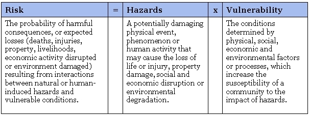
Table 1: Correlation between risk, hazard and vulnerability
Source of Definitions: UN/ISDR 2004
Hazards can include latent conditions that may represent future threats and
can have different origins: natural (geological, hydrological, meteorological
and biological) or induced by human processes (environmental degradation and
technological hazards). The most important hazards are:
Natural hazards:
Earthquake, volcanic eruption, mass movement (landslide, debris flow,
avalanche), windstorm (including tropical cyclone, tornado, blizzard etc.),
flood, tsunami, drought, forest fire.
Technological hazards:
Industrial pollution, nuclear activities and radioactivity, toxic wastes, dam
failures; transport, industrial or technological accidents (explosions, fires,
spills).
Hazards can be single, sequential or combined in their origin and effects.
Each hazard is characterized by its location, intensity, frequency and
probability (UN/ISDR 2004, p. 16) and might lead to a disaster.
A disaster is defined as a serious disruption of the functioning of
society, causing widespread human, material or environmental losses, which
exceed the ability of an affected society to cope using only its own resources
(EEA 2006). The extent of the disaster depends on both the intensity of the
hazard event and the degree of vulnerability of the society. For example a
powerful earthquake in an unpopulated area is not a disaster, while a weak
earthquake which hits an urban area with buildings not constructed to withstand
earthquakes, can cause great misery (GTZ 2001, p. 14).
Due to this fact, hazard events are only classed as catastrophes when human
beings or their property are affected. The term natural catastrophe is
used when a natural event is so intense that people suffer and material assets
are affected to a substantial degree and on a more or less large scale. A
“great” natural catastrophe is defined by the United Nations as a natural
catastrophe that distinctly exceeds the ability of an affected region to help
itself and makes supra-regional or international assistance necessary (cited in
Munich Re Group 2005, p. 12). Generally this is the case when there are
thousands of fatalities, when hundreds of thousands of people are made homeless,
or when economic losses – depending on the economic circumstances of the country
concerned – and/or insured losses reach exceptional extents.
The causes of such a catastrophe are manifold. The most important
influential factors of increasing disasters are the following:
- Population growth and gross socioeconomic inequities between
rich and poor countries, which lead to an over-exploitation of natural
resources.
- Global climate change, which in long term result in earth warming
and an increasing ocean level.
According to the World Urbanization Prospects 2005, a current database from
the United Nations Department of Economic and Social Affairs, the total
population will increase from 6.4 billion in 2005 to 8.2 billion in 2030. Most
of the expected population growth will be concentrated in the urban
agglomerations of the less developed countries. By 2007, for the first time in
human history, more than half the people in the world will be living in cities.
The development with regard to observed increase in global warming is not
less fast and dramatic. According to the Third Assessment Report (TAR) of the
Intergovernmental Panel on Climate Change (IPCC), the global average surface
temperature has increased by about 0.6°C over the 20th century. The report
analyzes that the average surface temperature is projected to increase by 1.4 to
5.8°C over the period 1990 to 2100, and the sea level is projected to rise by
0.1 to 0.9 metres over the same period (IPCC 2001).
A large interdependency can be determined between these two described causes.
It is difficult to say whether the increase in disasters is related to climate
change, or the fact that population growth increase the number of people
affected by disasters.
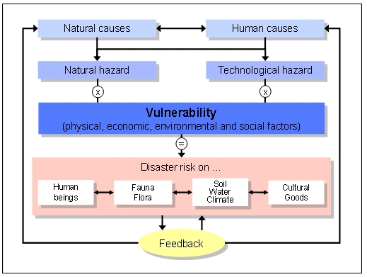
Figure 1: Disaster risk as the product of hazard and vulnerability
The effects of the described changes are different:
- The increase of population and consumption has reached unsustainable
levels and leads to a loss of biodiversity and rising imbalance between
protection and use of natural resources.
- This overall intensification of natural resource utilization increases the
environmental degradation and decay of the key ecosystems (land
degradation, erosion, deforestation, air, water, and soil pollution).
- The urban growth leads to an increase in vulnerability of major
metropolitan areas to disasters.
Primarily the uncontrolled and uncoordinated urban growth causes a lot of
different ecological, economic and social problems and risks. Considering the
high density and the large number of inhabitants combined with the accelerated
urban development, especially so-called megacities and urban agglomerations run
highest risk in cases of natural and human-caused disasters (cf.
Kötter/Friesecke 2005). It is expected that the vulnerability of the society and
the human environment as well as the threat by disasters will intensify
continuously in the future.
1.2 Recent Global Trends of Disasters
The number of natural and human-made disasters is on the rise worldwide. With
regard to major disasters in the recent past, two events bear in remembrance:
Earthquake and Tsunami in South East Asia (December 2004)
On December 26, 2004, South Asia was hit by one of the most devastating
natural catastrophes of recent decades. The largest earthquake since 1964 caused
devastating tsunami waves that killed nearly 230.000 people in Indonesia, Sri
Lanka, South India, Thailand and the Maldives, making it one of the most deadly
catastrophes in modern history.
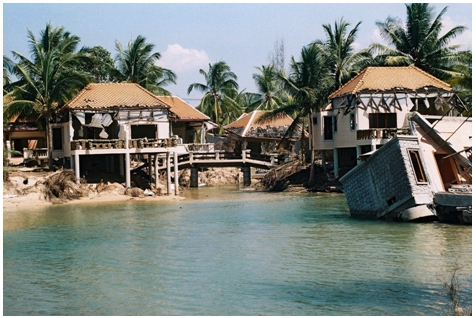
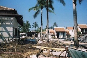
Photo 1: The aftermath of the tsunami in South East Asia, Khao Loak South
(Source: Munich Re Group)
Hurricane Katrina in North America (August 2005)
Hurricane Katrina was a tropical cyclone that hit the southern States of
America in August 2005 and was the most destructive and costliest natural
disaster in the history of the United States. After landfall on August 29,
several sections of the levee system of New Orleans collapsed so that up to 80%
of the city was underwater. Experts estimate a total economic damage of over $
75 billion.
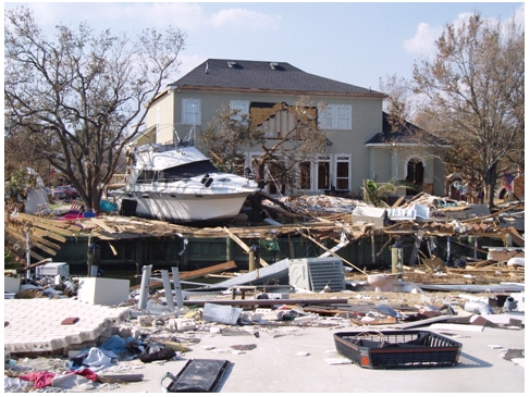
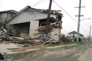
Photo 2: The aftermath of Hurricane Katrina 2005 (Source: Munich Re
Group)
Besides smaller-scale disasters, especially these two catastrophic events
provide dramatic evidence of what nature’s power is capable of. In the past
decades, the damage due to natural and “un-natural” (or human-made) disasters
increased worldwide in amount and magnitude. Figure 1 shows the economic losses
and insured losses of major disasters during the second half of the twentieth
century up to now. According to investigations of the reinsurance agency Munich
Re the economic losses exceeded over 145 billion US $ in the year 2004, whereby
the trend took a progressive process in the last years (Munich Re Group 2005).
In 2005, there was an 18 per cent rise in disasters that killed 91,900 people
according to official figures issued by the Centre for Research on the
Epidemiology of Disasters (CRED) and the United Nations International Strategy
for Disaster Reduction (UN/ISDR) in Geneva (UN Press Release January 30, 2006).
Until the year 2050 the number of fatalities by natural catastrophes will
increase up to an average of 100.000 persons per year; at the same time an
increase of the annual economic losses up to 300 billion US $ is expected
(Munich Re 2003). Alone the number of people worldwide vulnerable to a
devastating flood is expected to grow to 2 billion by 2050 due to climate
change, deforestation, rising sea levels and population growth in flood-prone
lands, warn experts at the United Nations University (UNU-EHS News Release June
13, 2004).
It is obvious that the major part of the damage will take place in developing
countries with a dramatic impact on poor people and ethnic minorities. Countries
with low human development account for 53 percent of recorded deaths from
disasters even though they are home to only 11 percent of the people exposed to
natural hazards worldwide (UNDP 2004, p.10).
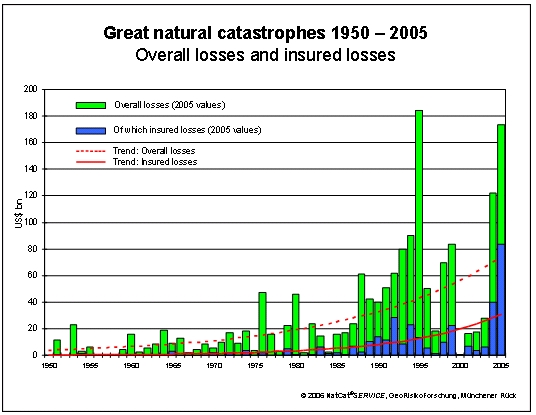
Figure 2: Economic and insured losses with trends (Source: Munich Re
Group 2006)
The serious impacts on the global environment show that there is an urgent
need for more and better urban development strategies for disaster risk
assessment and risk reduction.
2. Disaster Risk Management and its
Components
Instead of starting with the focus on natural hazards and
their quantification, the assessment and ranking of the vulnerability of
affected groups should serve as the starting point in defining priorities and
remedial interventions.
Dr. Janos Bogardi, Director of UNU-EHS, 2004
Due to the increasing frequency of disasters worldwide, a lot of
international organizations, governments and NGOs like FIG are upgrading the
priority of disaster risk management for policy, and are developing techniques
and tools for disaster mitigation, rehabilitation and reconstruction.
According to ISDR Secretariat disaster risk management means the
systematic process of using administrative decisions, organization, operational
skills and capacities to implement policies, strategies and coping capacities of
the society and communities to lessen the impacts of natural hazards and related
environmental and technological disasters. This comprises all forms of
activities, including structural and non-structural measures to avoid
(prevention) or to limit (mitigation and preparedness) adverse effects of
hazards (cf. UN/ISDR 2004 and www.unisdr.org).
Generally, the disaster risk management process (cycle) is composed of the
following main elements (cf. UN/ISDR 2004 and figure 3):
- Risk identification and assessment (determining and
analyzing the potential, origin, characteristics and behaviour of the hazard –
e.g. frequency of occurrence/magnitude of consequences)
- Knowledge management (information programs and systems, public
awareness policy, education and training, research in disaster reduction)
- Political commitment and institutional development (good
governance to elevate disaster risk reduction as a policy priority,
integration in development planning and sectoral policies, implementing
organizational structures, legal and regulatory framework)
- Application of risk reduction measures (planning and implementation
of structural interventions (e.g. dams, dikes) or non-structural measures like
disaster legislation)
- Early warning (provision of timely and effective information,
through identified institutions, that allow individuals exposed to a hazard,
to take action to avoid or reduce their risk and prepare for effective
response)
- Disaster preparedness and emergency management (activities
and measures taken in advance to ensure effective response to the impact of a
hazard, including measures related to timely and effective warnings as well as
evacuation and emergency planning)
- Recovery/Reconstruction (decisions and actions taken in the
post-disaster phase with a view to restoring the living conditions of the
affected population)
Based on the above specified components, disaster risk management includes
measures before (risk analysis, prevention, preparedness), during
(emergency aid) and after a disaster (reconstruction). Sometimes disaster
risk management includes only a part of disaster management, focusing on the
before of the extreme natural event (cf. GTZ 2004, p. 18).
However, each risk reduction measure has to be evaluated regarding its
technical functionality, economic costs and efficiency as well as social and
ecological effects (ESPON 2005).
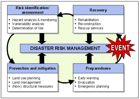
Figure 3: Key elements of disaster risk management
In the context of disaster risk management, various activities and
initiatives at national and international level show the increasing
relevance of disaster reduction, e.g. the United Nations International Strategy
for Disaster Reduction (ISDR) as well as the Centre for Research on the
Epidemiology of Disasters (CRED). The joint aim of all activities is to reduce
the risk of social, economic and environmental impacts of natural hazards on
vulnerable populations, within the broad context of sustainable development.
In addition, the United Nations Conference on Environment and Development,
Rio de Janeiro (1992), the Millennium Development Goals (2000), the World Summit
on Sustainable Development, Johannesburg (2002) and the World Conference on
Disaster Reduction, Kobe (2005) have promoted improved linkages between
sustainable development and disaster risk reduction. Besides the implementation
of case studies, priority was given to create comprehensive guidelines that
could be used by governments, international (partly non-governmental)
organizations and society to help avert losses from natural and technological
disasters.
However, as the latest disasters have clearly illustrated, more than ever a
holistic approach to disaster risk management is needed in order to enhance
resilience and reducing vulnerability to disasters. Scientists and engineers can
contribute to this major challenge for disaster reduction by continuing and
intensifying research on the natural processes and creating new tools and models
for all phases of a disaster. This includes for example the development of
hazard mitigation strategies (e.g. sustainable land management) and data
collection systems that provide real-time and high quality data for use in
models for risk analysis, forecasting and early warning. The possible
contribution of the surveying profession will be described in the following
chapter.
3. The Need of the Surveying Profession in
Dealing with Disasters
For thousands of years they measure, divide the earth, draw
maps
– surveyors and cartographers.
Prof. Z. Adamczewski, Warsaw
3.1 Introduction
The modern surveyor can play an important role in the field of disaster risk
management, although in most cases, the activities will take place as part of
multi-disciplinary task forces.
About 80 % of daily decisions on national or local level, either in
economy, finances / taxation, demography, spatial planning, environment, hazard
areas, infrastructure, housing, cultural heritage, etc. are spatially or
geo-referenced. That demonstrates clearly, surveying is a central pillar of
each country and its economy (Magel 2005). Roberge has a more sceptical view of
the situations in which surveyors get involved concerning disaster risk
management: “Our contribution is neither spectacular nor glamorous. We are not
under the spotlight like rescue teams, policemen, doctors, etc. Nevertheless,
our role is no less important but merely, too often, unknown or misunderstood”
(Roberge 2005).
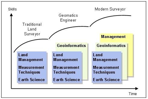
Figure 4: The change of geodetic activities from traditional tasks to new
methods (modified, according to Schulte 2005)
As visualized in figure 4, there is an irreversible process of
professional change in surveying methods and applications in the past
decades. Whereas the surveyor in former times (only) had profound knowledge in
areas of work such as Earth sciences, measurement techniques and land
management, the modern surveyor needs also skills in (geo-)informatics and
management. Requirements are not only engineering know-how but also knowledge in
business administration (planning, organizing, leading, co-ordinating and
controlling) as well as the development and management of databases of geo-data.
The modern surveying engineer assists in acquiring, managing, visualizing and
analyzing geospatial data related to disasters. Combined with new technologies
and methods, the challenging profession delivers the basic principles for
disaster risk management within the disciplines geodetic engineering,
satellite-based positioning, photogrammetry, remote sensing, geoinformatics and
land management (fig. 5).
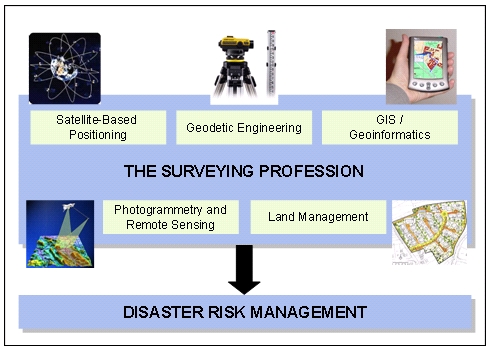
Figure 5: The need of surveying methods and applications for disaster
risk management
However, the five geodetic disciplines listed in figure 5 have to be seen in
close interrelationship. The key for success lies in the collaboration and
networking between the different disciplines and techniques, e.g. because of the
fact that geographic information systems use airborne and satellite data as well
as radar and (multi-spectral) images. Of course, as already mentioned, not only
the surveyor can contribute to the prevention and mitigation of disasters. The
multi-sectoral and interdisciplinary approach to disaster reduction requires
interaction, co-operation and partnerships among all related stakeholders and
institutions (i.e. local authorities, civil society and private sector).
The following chapters want to enumerate the geodetic contribution in the
field of disaster risk management. They will show us that, due to the
versatility of our profession, the tasks of a surveyor can be seen primarily in
four groups of objects:
- Acquisition of disaster-relevant data by using different data
sources such as airborne and satellite data; radar and (multi-spectral) images
- Hazard assessment and design of monitoring and/or early
warning systems as part of Geographic Information Systems (GIS) and
other computer-based information systems
- Development and implementation of preventive measures of land
use planning and land management to reduce disaster damage
- Cadastral reconstruction using Global Positioning Systems
(GPS/GLONASS)
and/or Tacheometry in the post-disaster phase
Especially tools to monitor the risk evolution process are very important.
Disaster reduction measures should be based on continuous assessment of
vulnerability and hazards, including a vulnerability/hazard analysis and
monitoring. Photogrammetry, for instance, is an efficient tool in the monitoring
of spatial objects like volcanoes or mass movements with respect to location
form and size (Altan 2005, p. 311). The surveyor as an expert in geoinformatics
can support the first steps of the disaster risk management cycle, establishing
geographic information systems for risk analysis, monitoring and early warning
systems. Besides that, virtual 3D city models can provide important information
in case of severe destruction of infrastructure to facilitate localization in
indoor and outdoor navigation (Kolbe, Gröger, Plümer 2005).
Furthermore, land use and urban planning can help to mitigate disasters and
reduce risks by avoiding construction of settlements and key facilities in
hazard prone areas, control of population density and expansion.
In the post-disaster phase surveyors’ contribution of cadastral
reconstruction to the redevelopment of the affected areas is needed.
Haroen/Achmad/Rusmawar explain the new cadastral approaches after the tsunami
and earthquake in Aceh (Haroen et al 2005). A surveyor as an urban planner can
contribute to the rehabilitation of housing, infrastructure and public
facilities and to reduce the future vulnerabilities of human settlements.
3.2 Geodetic Engineering and Satellite-Based Positioning
Monitoring and Early Warning using Geodetic Measurement Techniques and
Satellite Based Positioning
The main focus of disaster risk management is often dedicated to monitoring
of objects, areas, regions or even the whole earth with the aim to give warning
to the people that may be affected by a disaster at right time. In general we
talk about early warning systems. Early-warning-systems are essential for almost
all natural and human-made disasters as mentioned in chapter 1.1. Exemplary
catastrophes that are monitored and forecasted by geodetic means are mentioned
in the following: earthquake, volcanic eruption, landslide, tsunami, dam or
bridge failures.
Obviously to build up early warning system one requires highly
interdisciplinary teams: different scientists and engineers have to work
together. If one is talking e.g. about tsunamis one needs geologists,
geophysicists, hydrologists; to avoid bridge failures the knowledge of civil
engineers is non refusable. But in parallel to all monitoring tasks is the need
for geometric quantities in the sense e.g. of positions of objects in absolute
sense or in relation to other objects or in distances between points on one
object. To measure positions and other geometry related quantities a surveyor is
needed to design, develop and implement the respective measurement systems as
well as to evaluate and analyse the measured quantities. Therefore the knowledge
of a geodetic engineer is non substitutable in any of the named early warning
applications.
The Contribution of the Surveying Profession
As written before the main role of the surveyor is the one as a geodetic
engineer that cooperates in an interdisciplinary team. One’s duty is to deliver
the geometric quantities required and – even more important – to describe the
quality of the data in a way the other partners of the team may understand it
and use it for their interpretation and their catastrophe forecasting models.
Some of the most important tasks carried through by the surveyor as a
geodetic engineer are
- design, development and implementation of measurement systems on the basis
of the dynamic object model using e.g. methods of sensitivity analysis,
- process, evaluate and adjust the geodetic measurements, including models
and analysis of time-dependent measurements as well as deformation analysis,
- develop and implement algorithms for data fusion, partly in cooperation
with other disciplines that deliver measurement data too (e.g. geotechnical
measurements),
- model, describe, measure and propagate the quality of geodetic data,
- manage and visualise measurements and results as well as
- coming to decision within the disaster risk management process in an
interdisciplinary team.
The measurement instruments used for early warning systems depend on the
required quality especially the accuracy demands as well as to the extension and
the environment of the monitored object, area or region. So for tasks as early
warning with respect to tsunamis or volcanic eruptions large areas or regions
are monitored. Here satellite based positioning methods are applied. For small
extensions as valid for constructions like bridges or dams and for e.g.
landslides higher accuracy is required, so that tacheometers as well as other
specialised instruments like digital levels, tiltmeters or inclinometers are in
use. For an overview we refer to Foppe et al. (2004).
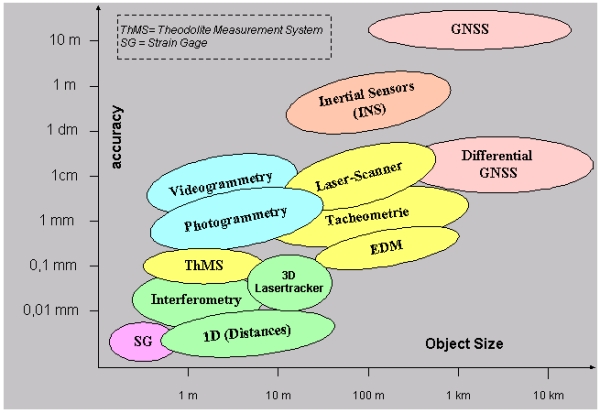
Figure 6: Measurement instruments in relation to accuracy and object
expansion (Source: Foppe et al. 2004)
Good-Practice-Examples
Monitoring of slopes with respect to landslides
One typical example regarding early warning is the monitoring of slopes with
respect to possible landslides. Regarding the behaviour of the slope one has to
consider the landslide classification by the UNESCO Working Group for World
Landslide Inventory (fig. 7) for the modelling as well as further information
regarding the geological and tectonic background of the slope.

Figure 7: Classification of landslides according to UNESCO Working Group
for World Landslide Inventory
(Source: Foppe & Schwieger, 2000)
For this we need interdisciplinary teams consisting of geodesists and
geologists. One of the first projects dealing with interdisciplinary research
work was the “Geotechnical Information System” in cooperation of geologists from
the Geological Institute Mainz and geodesist from the Geodetic Institute
Hannover (Foppe & Matthesius, 1994). The objective of the project was fast and
precise monitoring of the actual state of the monitored slope. Different slopes
in south Germany were investigated within this project. The geodetic as well as
the geotechnical measurements were integrated in one information system that
allows the analysis and interpretation of the results. The geodetic engineers
were responsible for building up a Geotechnical Information System including
data acquisition, management and deformation analysis.
This interdisciplinary cooperation example has taken its continuation in
several scientific projects as well as practical implementations leading to an
integration of the geodetic engineer into landslide monitoring projects due to
his knowledge about data acquisition, data processing and modelling of the
likely sliding slope. As an example the new project InterRisk (Integrative
Landslide Risk Analysis and Perception in the Swabian Alb) as cooperation
between geologists, geographers and geodesists may be given. Here among other
things the derivation of correlations between external factors like rain fall
and geometric quantities, the measured deformations, are under research (e.g.
InterRisk 2006, Schauerte et al. 2006).
Tsunami Warning System
On a larger scale tsunami warning systems are currently of high interest. For
example the GeoForschungsZentrum Potsdam (GFZ) will co-develop a part of the
IOTWS (Indian Ocean Tsunami Warning System) near Indonesia. This development is
a German-Indonesian cooperation called GITEWS (German Indonesian Tsunami Early
Warning System) granted by the German government (BMBF 2004).
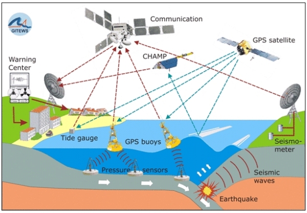
Figure 8: Indian Ocean Tsunami Warning System (Source: GFZ 2006)
The system will integrate terrestrial observation techniques like
seismometers and tide gauge measurements by GPS as well as marine measurements
on GPS buoys and with ocean bottom pressure sensors and the processing centre in
Indonesia (compare fig. 8). The base is the already available global earthquake
monitoring system of GFZ and its also available real-time communication
technique. Overall the system consists of four chain links: the data
acquisition, the data processing, the validation and the warning component. The
final implemented system will have an open and modular character to ensure the
possibility to be further enlarged without problems.
The development and implementation of the system is accompanied by capacity
building in the sense of training of local scientists, engineers and decision
makers in Indonesia regarding measurement techniques, tsunami modelling and
information processing. In this way the technical objectives of the GITEWS are
supplemented by additional efforts aiming to develop human skills to reduce the
level of risk in Indonesia.
The GITEWS team is highly interdisciplinary consisting of geophysicists,
hydrologists, computer scientists and of course geodetic engineers. The positive
fact is that the scientists and engineers of this project have already done
research in the same organisation like GFZ before project start. This
illustrates the importance of interdisciplinary research centres for activities
regarding disaster risk management and especially early warning systems.
The Way Forward
Still surveyors are seen as supplier of measured geometric data. This has to
be changed dramatically. The geodetic engineer has to be an equal partner within
the discussions. Even more the surveyor may play in important part in the
decision process, since in general he delivers the respective geometric
information that is essential for releasing an alarm in any early warning
system. In other words the geodetic measurements drive the emergency planning
tasks thus steering the whole process of disaster risk management in case of an
impending event. This leads to the conclusion that the surveyor should be one of
the key decision makers in any monitoring and early warning team.
Additionally the knowledge of surveyors regarding modelling of dynamic
systems like construction or slopes should lead to an equal role for the
evaluation and optimization of these dynamic models describing the behaviour of
the monitored objects. In general the specialists that collaborate with the
surveyors see any involvement into “their” objects and processes as a danger for
their profession. This means that a civil engineer does not like discuss their
dynamic construction models with geodesists and that geologists do the same with
landslide models. We have to explain to our colleagues that a win-win situation
is generated in case of shared knowledge. The interdisciplinary cooperation
would be even more purposeful. Finally the assessment of risks would be possible
with the help of geodesists in case of a real interdisciplinary cooperation.
3.3 Photogrammetry and Remote Sensing
Photogrammetry is an efficient tool in monitoring spatial objects due to
location, form and shape. Its main advantage to other measuring techniques lies
in the fact that the measurement is done on the images and indirect measuring
possibility opens the users of this method a wide range of application
possibilities. One of the contributions is the use of terrestrial
photogrammetric methods to determine the monitoring, documenting and
analyzing the damages in the structures after an earthquake. Today with the help
of digital data capturing, on-line processing techniques and automation of data
evaluation by means of image analysis and matching techniques is enabled. In
this context 3D-object reconstruction techniques, classification or image
detection and their integration into a deformation analysis procedure using
information system technology is used. So after a short time and nearly on-line
the deformations of the building can be determined and obtained, the
displacements values are controlled with the values given in the “Structural
Codes”. With this very fast data acquisition technique the civil engineers gain
an efficient tool to determine whether a damaged building will be kept for
retrofitting or be demolished.
Aerial photogrammetric data acquisition techniques give very accurate
data about the damaged area and are a very good tool for coordinating rescue
operations after a disaster. The data gaining method named as LIDAR (= LIght
Detection And Ranging) is a weather and day light independent method which
provides data very fast and enables to detect the damaged parts of a city or
residential areas automatically.
Earth observation satellites have demonstrated their utility in
providing data for a wide range of applications in disaster risk management.
Pre-disaster uses include risk analysis and mapping; disaster warning, such as
cyclone tracking, drought monitoring, the extent of damage due to volcanic
eruptions, oil spills, forest fires and the spread of desertification; and
disaster assessment, including flood monitoring and assessment, estimation of
crop and forestry damages, and monitoring of land use/change in the aftermath of
disasters. Remotely sensed data also provide a historical database from which
hazard maps can be compiled, indicating which areas are potentially vulnerable.
Information from satellites is often combined with other relevant data in
geographic information systems (GIS) in order to carry out risk analysis and
assessment. GIS can be used to model various hazard and risk scenarios for the
future planning and the development of an area.
Photo 3: High Resolution QuickBird image of the devastated area - Tsunami
in Southeast Asia, December 26, 2004 (Source: Prof. Altan)
A proposed concept of a geo-space system for prediction and monitoring
earthquakes and other natural and man-made catastrophes, which is based on a
system capable of monitoring precursors of earthquakes in the ionosphere and
magnetosphere of the Earth and using these precursors to make short-term
forecast of earthquakes. Investigations on the interaction between ionosphere’s
F layer variations and different variations occurring in circumterrestrial
environment (atmosphere, ionosphere and magnetosphere) associated with seismic
activity, and detected by means of ground base and satellite monitoring. This
method and others like GPS measurements for long distances are providing useful
parameters for earthquake forecasting.
Realizing the fact that the remotely sensed data can help very much for the
disaster risk management, at its forty-fourth session, the Committee on the
Peaceful Uses of Outer Space agreed to establish action teams composed of
interested Member States in order to implement the recommendations of the Third
United Nations Conference on the Exploration and Peaceful Uses of Outer Space
(UNISPACE III). One of the action teams focused on studying and recommending the
implementation of an integrated operational global system, especially through
international cooperation, to manage natural disaster mitigation, relief and
prevention efforts through Earth observation, communications and other
space-related services, making maximum use of existing capabilities and filling
gaps in worldwide coverage. Several UN Member States expressed their support for
the work being carried out by the action team, emphasizing the importance of
creating an entity (DIMISCO; Disaster Management International Space
Coordination Organization) in that it could promote more effectively the
application of space technology in disaster reduction and management at the
global level, and in developing countries in particular, and their preference of
setting up such an entity under the umbrella of the United Nations in order to
guarantee universal access. It is planned that the proposed entity will be
operational on 1 January 2007.
3.4 GIS and Geoinformatics
Spatial Data Information is one of the core subjects in disaster
prevention and emergency aid. To guarantee, e.g., for speed and efficiency of
rescue operations all information should be available at a glance in the control
units and in the mobile rescue units as well. In an emergency case, not only the
location of the event but many other information is needed, like ‚How many
people are affected?‘, ‚Which road network is available?‘, ‚Can the location be
reached by vehicles?‘ ‚Where are the most nearby hospitals located?‘ ‚How much
and which kind of capacity do the hospitals have?‘ Such and many other questions
can be answered very quickly if and only if reliable spatial data are available
in digital form and if the data are processed in a powerful Geo Information
System (GIS).
Recently, many IT developments took place which can help to speed up
the information flow considerably. The availability of Internet access
points, the widely common IT infrastructure within the Internet, the
standardisation process defining spatial data processing procedures all together
provide for the IT base of a spatial data infrastructure to support a powerful
spatial information management which can be used as a valuable source of
suitable disaster management. The spatial data infrastructure should be
consistently implemented across sub-national and national boundaries because
disaster areas typically do not coincide with administration boundaries.
Geo Information Systems can help to support all phases of emergency
management, like mitigation, preparedness, response and even recovery.
Depending on the specific tasks, different types of GIS are to be
used:
- Spatial information portals and data warehouses
- Modelling and simulation systems
- Monitoring and early warning systems
- Planning support systems
Special tasks which can be performed in such a GIS system may include:
- Use of spatial data and object related data from various sources
- Integration of mobile action force information in near real-time
- Providing adequately processed intersected data including decision support
signals for control centres and field staff
- Information retrieval support
- Information intersection support
- Decision process support
- Scenario projection of retrieved intersected information
- Database of predefined scenarios
- Extension of existing databases and cadastres
- Connection of existing disaster management systems via open standard
interface
- Logging of activities for the purpose of documentation
Contribution of the Surveying Profession
Traditional skills of a surveyor, like quality awareness, are a
valuable contribution and can help to support the quality assurance of spatial
data and of spatial information processes as well. Spatial data processing needs
the data management capabilities of surveyors. In the field of land
information systems, surveyors possess a sound experience in maintaining huge
spatial databases at a very high level of reliability since a long time. This
knowledge can be used to support the implementation of other but, technically
spoken, similar spatial information systems which provide for an absolutely
indispensable base for the effective disaster risk management.
Good-Practice-Example
The given figures show a prototype of how to request and receive an automatic
access route generation via Internet under the conditions of an upcoming
emergency case. The syntax of such a request is given in GML notation, the
result obtained by the request is shown as a computer screen shot.
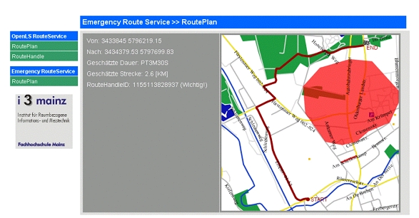
Figure 9: Emergency route service, a special routing system adapted to
the needs of emergency aid
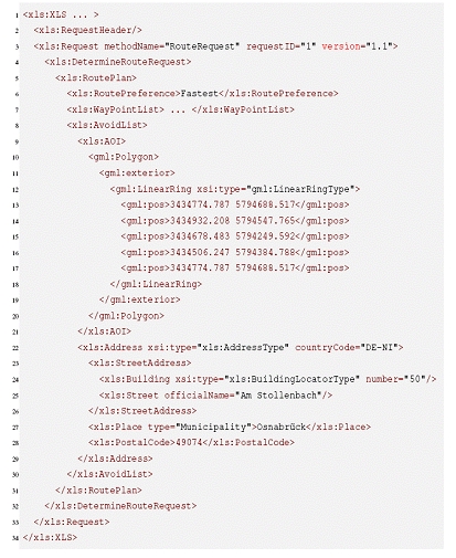
Figure 10: GML Geography Mark-up Language notation, the IT base of
interoperability between different partners in emergencies
3.5 Land Management and Land Use Planning
Land Management and Land Use Planning as a Tool of Risk Prevention
Land is an ultimate natural resource, without it life on earth cannot be
sustained. As a result of the dramatic increase in population growth and poverty
especially in the developing countries, people increasingly settle and farm in
disaster-prone areas, where land is often more fertile in comparison to other
locations. The consequences are dramatic: A great number of people are
vulnerable to extreme natural events due to a lack of land use planning.
In the context of disaster risk management effective land management and land
use planning can help to mitigate disasters and reduce risks by avoiding human
settlements in hazard prone areas, control of population density and expansion.
Generally, land management can be defined as the process of managing
the use and development of land resources in a sustainable way, or in other
words is the process by which the resources of land are put into good effect
(UN/ECE 1996, p. 13). It contains all activities associated with the management
of land and natural resources that are required to achieve sustainable
development (Enemark 2005) and contributes particularly to safeguard property
rights and property accessibility. To attain these goals the complex and
interdisciplinary concept of land management includes the four areas (according
to Enemark 2004, 2005):
- Land tenure (securing and transferring rights in land and natural
resources),
- Land value (valuation and taxation of land and properties),
- Land use (planning and control of the use of land and natural
resources) and
- Land development (implementing utilities, infrastructure and
construction planning).
Unfortunately, these instruments have often been used with little regard to
the exposure of disaster risk. Non-existent or inadequate land use planning has
contributed to increasing the vulnerability of communities exposed to hazards
(UN/ISDR 2004, p. 315). Nevertheless, there are many ways in which risk
reduction can be integrated into land management and the land use planning
process helping to minimize human and economic losses as well as environmental
degradation due to disasters. Among others, the following tools and
strategies of land use and land development can be mentioned:
- Identification of disaster-prone areas as well as alternative sites that
are more suitable for development,
- Controlling the type of land use and land development in such areas (by
land use regulations and building codes),
- Retrofitting and building of settlements and homes adapted to disaster
conditions,
- Relocation of population vulnerable to disasters,
- Engineering measures and construction of hazard-resistant and/or
protective structures and infrastructure.
In addition to these direct measures of land management to reduce the
physical vulnerability of households and infrastructure, indirect measures
can be a basis for sustainable development and risk mitigation:
- Social benefit through public participation in land use management
practices,
- Precautionary environmental protection by reduction of soil sealing
and by protection of environmentally sensitive areas as well as
- Economic viability through decentralized development with a
poly-centric settlement structure (cf. Kötter 2003).
The Way Forward
As described above, an integrative and comprehensive approach of methods for
disaster reduction on the one hand and the strategies of land use planning and
land management on the other hand is missing so far. Improved land use and land
management strategies and instruments are needed that combine the land
administration/cadastre/land development function with the process of disaster
risk management. Therefore, especially security of land tenure, access to land
and control of land use in hazard-prone areas are central issues to minimize
vulnerability of populations to future crisis and disasters. This includes
creation and adoption of a comprehensive policy on land management with
regard to disaster prevention and mitigation as well as sustainable development
(cf. figure 11).
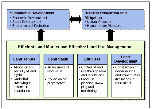
Figure 11: Sustainable land use management as a tool for risk reduction
(modified, according to Enemark 2004, p. 8)
However, the first steps in achieving these goals have been taken.
Institutional and public awareness is increasing. The implementation of
sustainable land management will help to promote economic and social development
in both urban and rural areas and will lead to a better disaster reduction.
Whereas current disaster management strategies tend to favour structural
measures (engineering solutions), one can notice a change of paradigm towards
non-structural measures such as land use and building regulations or special
disaster legislation. Concerning flood prevention, for example, the key
objective is to leave more room for rivers, particularly for their natural flood
plains, or to give the space back to them. To achieve this goal, measures for
moving dikes further away from river banks as well as conservation or
restoration of flood plains have to be implemented in the flood protection
strategies. This includes certain restrictions on the construction of buildings
in areas classified as “at risk of flooding” and agricultural use in high-risk
areas (Friesecke 2004).
Contribution of the Surveying Profession
With its specialized skills the professional surveyor can substantially
contribute to helping to mitigate disasters and to reduce risk. Requirements are
not only engineering know-how but also the surveyors’ variety of skills and
knowledge in urban and rural planning, land management and development, building
and land law, real estate and business administration, ecology, nature and
landscape conservation as well as social competence. Among other things, the
surveyor as a land manager:
- develops effective land use concepts that are necessary for a sustainable
urban and rural development,
- coordinates and directs the complex procedures of land consolidation, land
registration and land reallocation,
- creates sustainable infrastructural, economic and ecological conditions
for developing urban and rural areas and solving land use conflicts,
- coordinates public-private agreements in order to use land in a economic,
ecological and social way and
- undertakes damage assessment of the destroyed or harmed buildings and
public facilities in the aftermath of a disaster.
However, it’s not the surveyor alone, who contributes to disaster risk
management with special regard to land management. Land management and land use
planning are interdisciplinary tasks that shift the responsibility for the
described strategies and measures on various occupational groups.
Good-Practice-Example
Flood Prevention by Land Consolidation
Land consolidation can be an effective instrument in rural development for
preventative risk reduction. On the one hand, it can facilitate the creation of
competitive agricultural production arrangements by enabling farmers to have
farms with fewer parcels that are larger and better shaped, and to expand the
size of their property. But, on the other hand, because of the growing
importance of flood protection, land consolidation has become an increasingly
important instrument in increasing water storage capacity, redeveloping flood
plains and renaturalizing rivers.
In reference to flood risk management, efficient and long-term land
consolidation combines water management, regional planning and rural
development, agriculture and nature conservation measures in an
interdisciplinary concept. Concerning flood prevention, the “new” objectives are
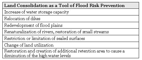
Table 2: Fields of action for preventative flood management by land
consolidation
There is a growing realization that the above mentioned flood mitigation
measures must be combined in an integrated approach to flood disaster
management. A balance between structural and non-structural measures to manage
floods is required, where the main focus is shifting from large structural
solutions to non-structural approaches such as avoiding building development in
flood plains.
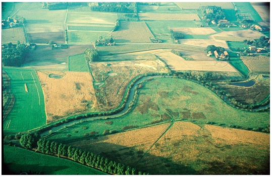
Photo 4: Land Consolidation project ‘Hellinghauser Mersch’ at the river
Lippe in Germany (Source: Helle, R.)
In relation to the process of land consolidation, the use of surveyor’s
technical expertise is substantial. The surveyor as an engineer, land manager,
urban and rural planner, evaluator and expert in Geographic Information Systems
can be crucial for success in integrated rural and urban development. Besides
others, the areas of activities and responsibilities assumed by a professional
surveyor are the following:
- Photo flight of the land consolidation area including (automated)
interpretation of the imagery data
- Determination of new property boundaries (renewal of cadastre) with
- Tacheometry
- GPS Technology
- Creation and installation of Geographic Information System(s) – GIS
- Reshaping the land consolidation area (in consideration of the
requirements of spatial planning and of controlled rural development)
In particular GIS, GPS and the digital data transfer may importantly
contribute to simplifying work and to shorten the land consolidation procedure.
It is safe to say that the share of Surveyors during this process results in a
more cost-effective land consolidation! (cf. for more information Friesecke
2005).
3.6 Conclusions and Future Priorities
To be a good technician it is not enough to be a good
technician only.
Spanish Writer José Ortega y Gasset (1883-1955)
Conclusions
The modern surveyor is confronted with the introduction of new and enhanced
technology including scanning technology, both terrestrial and airborne, sensor
technology, GIS developments, the development of satellite navigation systems
(GPS/GLONASS) as well as the implementation of space missions for Earth
observation (e.g. CHAMP/GRACE).
With all this knowledge in Geodesy/Surveying/Geoinformation a professional
surveyor will be able to act in a wide spectrum of sectors within the disaster
risk management process (cf. also figure 12):
- Risk analysis and assessment: mathematical-statistical
analysis using geospatial data (airborne and satellite data; radar and
multi-spectral images); detecting and quantifying land cover and land use
change for hazard analysis and monitoring (e.g. by remote sensing); usage of
GIS in hazard mapping.
- Knowledge development: research in disaster reduction and disaster
control, e.g. research of the earth’s shape, sea level changes, gravity field
and plate tectonics.
- (Precautionary) disaster risk reduction measures: Land management;
development of land use concepts; deformation measurements for volcano or mass
movement monitoring; engineering surveys and monitoring of structural measures
(e.g. dams, dikes).
- Early warning: Technologies and techniques for early warning
systems, e.g. data acquisition and analysis; software development;
cartographic visualization; disaster modelling; usage of geodetic control
networks.
- Emergency management: use of virtual 3D models of towns, buildings
and landscape for an easier location in case of a disaster (evacuation and
emergency planning); supply of digital maps for emergency planning, mobile
mapping.
- Recovery/Reconstruction: documentation of damages (by laser
scanning or tacheometry); damage assessment of the destroyed or harmed
buildings and public facilities; cadastral reconstruction.
As the above specified fields of activity and the good-practice-examples in
the last sections show, the whole scope of surveyor’s abilities can make an
important contribution to improve the disaster risk management procedure,
including methods and measures before (risk analysis, prevention, preparedness),
during (emergency planning) and after a disaster (reconstruction).
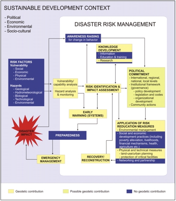
Figure 12: (Possible) geodetic contribution to disaster risk management
Source: UN/ISDR 2004, p. 15 (modified and supplemented)
In conclusion, the contribution of the surveying profession in disaster risk
reduction results in a more effective and efficient disaster risk reduction!
Future Priorities
Unmistakably, the surveying profession is in a period of unprecedented
change. Traditional measurement instruments and tools are and will be
supplemented or displaced by automated devices, new satellite navigation systems
(e.g. European system GALILEO), digital remote sensing sensors as well as new
space missions for Earth observation (e.g. GOCE).
This trend to the formation of new technologies and, closely connected with
that, new fields of professional activity will continue in the near future. To
be able to manage the new and complex challenges, well-skilled experts are
needed against the background of unresolved problems like population growth and
increasing disaster risk.
These new developments require an appropriate mixture of broad knowledge and
specialized expertise. According to Magel (2003), a surveyor should become a
»well grounded specialized generalist« with more business skills and knowledge
and the intention of more inter- and intradisciplinary collaboration in the
future.
To give an example with regard to disaster risk management, an important
contribution of the surveying profession can be made by political commitment
and institutional development (good governance to elevate disaster risk
reduction as a policy priority, integration in development planning and sectoral
policies, implementing organizational structures, legal and regulatory
framework).
Therefore, an increased engagement at the political level by heads of the
surveying profession is needed, which is still missing so far. The President of
FIG (Magel 2005) postulates that surveyors should play a manifold role as:
- enablers for local people, CBO (community-based organization) and
NGO (non-governmental organization)
- mediators between citizens and authorities as well as
- advisors to politicians and state institutions.
If we succeed in these priorities there is a great chance that the surveying
profession will have an even more prosperous future in the upcoming years.
4. Institutional and Organizational
Challenges of Disaster Risk Management
Good Governance is perhaps the single most important factor
in eradicating poverty and promoting development.
Kofi A. Annan, Secretary General of the United Nations
A comprehensive response to natural and human-made disasters is often
constrained by institutional fragmentation and organizational deficiencies. In
order to create a healthy environment for future generations, especially good
governance and capacity building are two areas that need to be
established globally to be effective tools for disaster reduction.
4.1 Good Governance and Disaster Risk Management
Governance is seen by the United Nations as the process of
decision-making and the process by which decisions are implemented (or not
implemented). It brings together the actions of several actors at all levels,
including government, ministries, international organizations, NGOs, research
institutes, universities and finance institutions.
Certainly, government is the dominant actor in moving towards sustainable
development and disaster risk management, but also the private sector and civil
society are playing an ever more active role in successful disaster risk
reduction. It is being increasingly recognized that disaster risk management at
the local level is a key element in any viable national strategy to reduce
disaster risk (cf. UNDP 2004, p. 76). In connection with this, the issue of
decentralization poses an important institutional challenge. Decentralizing the
leadership and authority of disaster risk management to the regional or
municipal level encourages local participation and engages people to volunteer
based on their own self-interest and community well being. According to Dr.
Janos Bogardi, Director of the Institute for Human Security and Environment
(UNU-EHS), especially participatory approaches where people at risk can take
part and effectively contribute to disaster reduction efforts are one area that
needs more attention and development.
Besides the aspect of participation, the other characteristics of good
governance — rule of law, transparency, responsiveness, consensus
orientation, equity, effectiveness, efficiency, accountability and strategic
vision — are a precondition for sustainable development and effective disaster
risk reduction (cf. Magel/Wehrmann 2001). In addition, good governance can be
seen as an effective instrument for poverty alleviation and to achieve the UN
Millennium Development Goals.
Nevertheless it should be clear that good governance is an ideal which cannot
be achieved completely. Only very few countries and societies have come close to
the key elements of good governance in its totality. However, to ensure
sustainable development and disaster risk reduction, measures must be taken to
work towards this ideal with the objective of making it reality. FIG as a NGO
aims at promoting good governance strategies, resulting in an integrated
economic, environmental and sustainable development. To achieve this goal, FIG
President Prof. Holger Magel’s statement at the 5th FIG Regional Conference in
Accra, Ghana in 2006 is extremely challenging: “Good governance is mainly based
on good land administration and needs both civil society and committed
professionals.”
4.2 Capacity Building to Reduce Disaster Risk
The ISDR Secretariat of the United Nations defines capacity building as the
efforts aimed to develop human skills or societal infrastructures within a
community or organization needed to reduce the level of risk (UN/ISDR 2004,
Annex 1).
In the context of disaster risk reduction, capacity building can be achieved
through disaster management training and education, public information on
disasters, the transfer, provision or access to technology or other forms of
technical assistance intended to improve institutional efficiency. The concept
also relates to the training of disaster managers, the transfer of technical
expertise, the dissemination of traditional knowledge, strengthening
infrastructure and enhancing organizational abilities (UN/ISDR 2004, S. 246).
Major disaster events in recent years, for example the 2004 Indian Ocean
earthquake as described in section 1.2, have shown the need for greater
education and information in disaster risk management. In these relatively poor
parts of the world, especially setting up the communications infrastructure to
issue early warnings is a big problem.
To achieve improvements concerning this goal, the process of capacity
development should be addressed at all levels and all sectors (cf. also FIG
2004, p. 25f.). In the 21st century, the key issues in capacity-building efforts
are strengthening the legal and organizational capabilities of institutions in
charge of disaster risk management and networking between them.
Figure 13 summarizes good governance and capacity building as a central
component regarding the process and implementation of disaster risk management
and sustainable development.
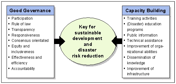
Figure 13: Governance and capacity building for risk reduction
Altan,
Orhan (2005): Use of Photogrammetry, Remote
Sensing and Spatial Information Technologies in Disaster Management, especially
Earthquakes, in:
Van Osterom, Peter; Zlatanova, Siyka; Fendel, Elfriede M. (editors) (2005):
Geo-information for Disaster Management. Springer
Berlin Heidelberg New York 2005, p. 311-322.
BMBF (2004): Aufbau eines
Tsunami-Frühwarnsystems im Indischen Ozean, der deutsch-indonesische Beitrag.
Bundesministerium für Bildung und Forschung (Federal
Ministry of Education and Research), Bonn / Berlin, 2004.
Deutsche
Gesellschaft für Technische Zusammenarbeit (GTZ) (2004):
Guidelines. Risk Analysis – a Basis
for Disaster Risk Management. Eschborn, June 2004.
Enemark, Stig (2004):
Building Land Information Policies. Proceedings of Special Forum on Building
Land Information Policies in the Americas. Aguascalientes, Mexico, October
26-27, 2004.
Enemark, Stig
(2005): Land Management and Development.
CLGE International Conference 2005,
Brussels/Belgium, 1-2 December 2005.
ESPON
Monitoring Committee (2005): The Spatial
Effects and Management of Natural and Technological Hazards in Europe.
European Spatial Observation Network (ESPON 2006) Project 1.3.1., 2005.
European
Environment Agency (EEA) (2006): Multilingual
Environment Glossary.
http://glossary.eea.europa.eu/EEAGlossary.
FIG
(2004): Marrakech Declaration - Urban-Rural
Interrelationship for Sustainable Development. Copenhagen, Denmark, FIG
Publication No.33, ISBN 87-90907-32-9.
www.fig.net/pub/figpub/pub33/figpub33.htm.
FIG (2005): Aguascalientes
Statement – The Inter-Regional Special Forum on Development of Land Information
Policies in the Americas. Aguascalientes, Mexico, FIG Publication No.34,
ISBN 87-90907-41-8.
www.fig.net/pub/figpub/pub34/figpub34.pdf.
Foppe, K., Matthesius, H.-J. (1994):
Abschlussbericht zum DFG-Projekt “Geotechnisches Informationssystem”
(Final Report on Project „Geotechnical Information System“). Wiss. Arbeiten der
Fachrichtung Vermessungswesen der Universität Hannover, Heft 228, 1998.
Foppe, K.,
Schwieger, V. (2000): Monitoring and Modelling of Landslides – State of
the Art and New Trends. Proceedings on Symposium “Present
Problems in Geodesy and Cartography”, Wroclav, Poland, 2000.
Foppe, K., Schwieger, V., Staiger, R. (2004):
Grundlagen kinematischer Mess- und Auswertetechniken.
Kinematische Messmethoden, DVW Schriftenreihe 45, Stuttgart,
February 17-18, 2004.
Friesecke, Frank (2004): Precautionary and
Sustainable Flood Protection in Germany – Strategies and Instruments of Spatial
Planning, 3rd FIG Regional Conference, Jakarta, Indonesia,
October 3-7, 2004.
Friesecke, Frank (2005):
Flood Risk Management – Flood Prevention by Land Consolidation in the Rhine
Catchment Area, FIG Working Week 2005 and GSDI-8 Cairo, Egypt, April 16-21,
2005.
German
Association of Surveying (Deutscher Verein für Vermessungswesen e.V.)
(DVW) (2005): Surveying. A
profession with new opportunities in geodesy, geo-information and land
management.
www.dvw.de/UserFiles/File/2_beruf/beruf.pdf.
GFZ (2006): Web-Page of
GeoForschungsZentrum Potsdam.
http://www.gitews.org/ 2006.
Haroen, Tony S.; Achmad,
Chairul B.; Rusmawar, Wenny (2005): Cadastral Reconstruction in Aceh: A
Newborn Concept of Adjudication. South East Survey Congress in Bandar Seri
Begawan, Brunei Darussalam, November 21-25, 2005.
Intergovernmental Panel on Climate Change (IPCC) (2001):
Third Assessment Report (TAR) – Climate Change 2001.
InterRisk (2006): Web-Page of
Project InterRisk.
http://www.giub.uni-bonn.de/sozgeo/interrisk/index.html, 2006.
Kolbe,
Thomas H.; Gröger, Gerhard; Plümer, Lutz (2005):
CityGML: Interoperable Access to 3D City Models,
in: Van Osterom, Peter; Zlatanova, Siyka; Fendel,
Elfriede M. (editors) (2005): Geo-information for Disaster Management.
Springer Berlin Heidelberg New York 2005, p. 883-899.
Kötter, Theo (2003):
Prevention of Environmental Disasters by Spatial Planning and Land Management,
2nd FIG Regional Conference, Marrakesh, Morocco, December 2-5, 2003.
Kötter, Theo (2004):
Disaster Management and e-land Management. In: GIM International,
November 2004, p. 12-15.
Kötter, Theo; Friesecke, Frank; (2005):
Urbanisation and Megacities – The Challenge of the 21st Century,
The 6th Open Meeting of
the Human Dimensions of Global Environmental Change Research Community,
University of Bonn, Germany
9-13 October, 2005.
Magel,
Holger; Wehrmann, Babette (2001): Applying Good
Governance to Urban Land Management – Why and How?
Zeitschrift für Vermessungswesen (ZfV), 6/2001, p.310-316
Magel, Holger (2003):
Bridging the Gap: About Integrating Survey and GIS,
Opening Speech at the ESRI “Survey and GIS Summit - Bridging the Gap 2003”, San
Diego, July 6, 2003.
Magel,
Holger (2005): About Surveyors’ Commitment,
Role and Education for Society and Sustainable Development,
Keynote Address at the Opening Ceremony of the 8th SEASC 2005 on
November 22, 2005 in Bandar Seri Begawan, Brunei Darussalam.
Magel, Holger (2006):
Promoting Land Administration and Good Governance,
Keynote address and Opening of the 5th FIG Regional Conference in
Accra, Ghana, March 8-11, 2006.
Munich
Re Group (2006): Topics Geo Annual review:
Natural catastrophes 2005. Knowledge Series, Munich 2006.
Renner,
Michael; Zoё, Chafe (2006): Turning Disasters
into Peacemaking Opportunities, in:
Worldwatch Institute (2006): The State of the World 2006, Washington D.C., p.
115-133.
Roberge,
Daniel (2005): After the Tsunami – How the
Surveying Profession Can Participate in the Reconstruction, FIG Working Week
and GSDI-8 Conference in Cairo, Egypt, April 16-21, 2005.
Schauerte, W., Bell, R., Glade, T., Kuhlmann, H. (2006):
Deformation Measurements of Landslides in the Swabian Alb within the Research
Project InterRisk. Proceedings on 3rd IAG Symposium on Geodesy
for Geotechnical and Structural Engineering and 12th FIG Symposium on
Deformation Measurements, Baden, Austria, 2006.
Schulte,
Karl-Werner (2005): Geomatics in the Context of
Real Estate. CLGE International Conference 2005, Brussels/Belgium,
1-2 December 2005.
United Nations Development Programme,
Bureau for Crisis Prevention and Recovery (UNDP/BCPR) (2004):
Reducing Disaster Risk. A Challenge for Development. A global report, New
York 2004.
United
Nations and Economic Commission for Europe (UN/ECE) (1996):
Land Administration Guidelines, New York and Geneva.
United Nations and Economic
Commission for Europe (UN/ECE) (2000): Guidelines on Sustainable Flood
Protection.
http://www.unisdr.org/eng/library/isdr-publication/flood-guidelines/Guidelines-for-reducing-floods-losses.pdf.
United Nations Inter-Agency Secretariat of the International Strategy for
Disaster Reduction (UN/ISDR)
(2004):
Living with Risk: A global review of disaster reduction initiatives.
United Nations, Geneva 2004.
United
Nations Population Division (2005): World
Urbanization Prospects: The 2005 Revision Population Database,
http://esa.un.org/unup/.
Wisner, Ben; Blaikie, Piers;
Cannon, Terry; Davis, Ian (2004): At Risk.
Natural hazards, people’s vulnerability and disasters.
Second Edition 2004, Routledge New York.
|