News in 2016

|
Land Consolidation and Land Readjustment for Sustainable Development
9-11 November 2016, Apeldoorn, the Netherlands
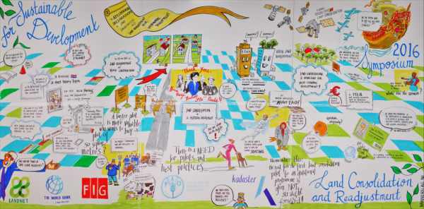
Cartoon report of the meeting. Click picture for larger image
Over 200 participants took part in this three day event, held from
November 9-11 2016 in Apeldoorn, the Netherlands. The event was related
to the celebration of 100 years land consolidation in the Netherlands.
Co-organisers were the Food and Agricultural Organisation of the UN,
Landnet and the International Federation of Surveyors and Kadaster,
Netherlands – with support from UN Habitat, the Global Land Tool Network
and the World Bank. Focus was on urban and rural environment and to
applications for sustainable development. The participants came from
fifty countries from all over the world.
Land consolidation and land readjustment is basically about improving
the structure of people to land relationships for one or more purposes.
This is usually associated with broad economic and social reforms. As an
implementation tool for spatial planning this can be combined with the
development of infrastructure, public services and water management. The
principles of both tools are basically the same: pooling of all the land
parcels in a particular area and planning them as a unit and then
dividing up the land again to the original land owner or user. A
proportion of the land can be used for public purposes such as
infrastructure, nature and public space.
Experts presented their research and project results during the
parallel sessions of the symposium. The global perspective contributed
to a collection of examples of how land consolidation and readjustment
can contribute to the Sustainable Development Goals of the UN.
Part of report
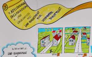
The symposium was concluded with the ‘Apeldoorn declaration on land
consolidation and land readjustment for sustainable development’. Here
it is said that there are some common principles in the use of the tools
– but no one-size-fits-all-solutions of land consolidation and land
readjustment exist. A comprehensive approach in land consolidation and
land readjustment favours a sustainable development in the way that it
benefits the people, planet and economic profit. The spatial component
of these instruments is a very powerful asset of land consolidation and
land readjustment to manage land use. The spatial rearrangement of land
rights can help mitigate the negative effects of for example climate
change, such as extreme rainfall or drought, rising sea levels, global
warming, salination, and the decline of suitable habitat for species
(biodiversity). However, it becomes even more powerful when it is
combined with additional policies and measures to address the causes of
unsustainable development. Surveyors and agronomists should closely
cooperate with ecologists in order to design reallocation plans with
“green fingers”. The FAO Voluntary Guidelines, the UN 2030 Agenda for
Sustainable Development and the New Urban Agenda from UN Habitat should
guide the application of Land Consolidation and Land Readjustment. In
all cases it is relevant to recognise a plurality of tenure types that
are relevant in negotiations around and planning for land consolidation
and land readjustment.
The treasures within this area of expertise to design resilient
landscapes is enormous. Awareness raising on the benefits that the
tools can bring is needed – especially for politicians and policy
makers.
Paula Dijkstra, Marije Louwsma and Christiaan Lemmen

29 November 2016


