News in 2022

|
FIG and the Sustainable Development Goals - Standards Network
September 2022
FIG Task Force on FIG and the Sustainable Development Goals together
with the ten Commissions have worked on their role on the sustainable
development goals relevant for their Commission.
Chair of the Standard Network David Martin gives his Statement on the sustainable development goals in relation
to the Standards Network
|

|
Standards have existed for thousands of years. The SDG's are
determined a few years ago. How do they relate? The role of the
Standards Network is mainly advising and supporting the Council and
Commissions. In this capacity, potentially all of the SDGs that are of
interest to FIG are relevant to the Standards Network. Perhaps more
precisely, Commission work related to the SDGs and requiring standards
support, or involving standards, could conceivably be relevant to the
Standards Network.
To put things in perspective, below the tasks of the Standards
Network are described:
- Building and maintaining relations with the secretariats of
standardisation bodies,
- Proposing priorities on FIG’s standardisation activities,
including advising the Council on priorities for spending,
- Setting up necessary Liaison relationships with standardisation
bodies,
- Ensuring that lead contacts to Technical Committees etc. are in
place,
- Maintaining an information flow on standardisation to FIG
members, including through the FIG website, and more directly to
relevant Commission Officers,
- Maintaining the Standards Guide, and related material on the FIG
website,
- Working with other NGOs, within the framework of the MOUs signed
by the Council,
- Advising FIG’s officers and members on standardisation
activities as necessary.
Reading more about standards & the SDG's
The SDG's are part of the 2030 Agenda for sustainable development.
UN-GGIM aims to address global challenges regarding the use of
geospatial information, including in the development agendas, and to
serve as a body for global policymaking in the field of geospatial
information management. Within UNGGIM the elements of the 2030 Agenda
and the SDG's have been integrated in their publications. Three
publications are recommended for further reading:
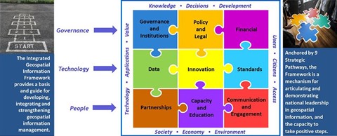
Framework for Integrated Geospatial Information Framework
The Integrated Geospatial Information Framework (IGIF) provides a
basis and guide for developing, integrating, strengthening and
maximizing geospatial information management and related resources in
all countries. It will assist countries in bridging the geospatial
digital divide, secure socio-economic prosperity, and to leave no one
behind.
Nine strategic pathways have are described. One pathway is dedicated
to Standards. This strategic pathway establishes, and ensures the
adoption of, best practice standards and compliance mechanisms that
enable legal, data, semantic and technical interoperability, which are
fundamental to delivering integrated geospatial information and
knowledge creation.
The objective is to enable different information systems to
communicate and exchange data, enable knowledge discovery and
inferencing between systems using unambiguous meaning, and provide users
with lawful access to and reuse of geospatial information
Integrated Geospatial Information Framework. Part 1: Overarching
Strategic Framework
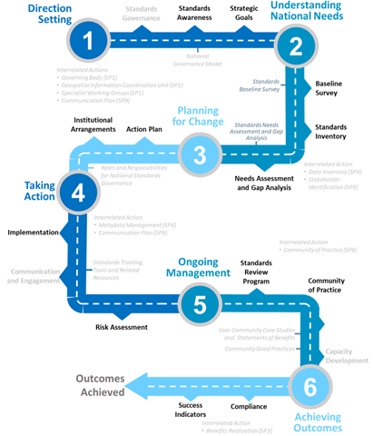
Implementation Guide UNGGIM Strategic Pathway: 6 Standards
Each pathway of IGIF is described in more detail in the
implementation guid. This strategic pathway establishes and ensures the
adoption of standards and compliance mechanisms for enabling data and
technology interoperability to deliver integrated geospatial information
and to create location-based knowledge.
The objective is to enable an efficient and consistent approach for
different information systems to be able to discover, manage,
communicate, exchange and apply geospatial information for a multitude
of uses, improved understanding and decisionmaking.
Implementation Guide UNGGIM Strategic Pathway: 6 Standards
A Guide to the Role of Standards in Geospatial Information
Management
Together with ISO, OGC and IHO an additional guide is published on
the role of standards in Geospatial Information Management. The purpose
of this Guide is to promote the recommendations regarding the use of
standards for geospatial information management. The Guide complements
Strategic Pathway 6 on Standards (SP6) of the Integrated Geospatial
Information Framework (IGIF) Implementation Guide.
It promotes the effective use of standards and helps users of
standards answer the question, "Where do I start?". It has a section for
each of the six actions recommended for the initial and early stages of
developing and strengthening geospatial information management
arrangements in a country, organization, or information community.
A Guide to the Role of Standards in Geospatial Information Management
David Martin
and Paula Dijkstra
September 2022