Executive summary
Paddy Prendergast
CLGE's Initiative to Enhance Academic Standards of Geodetic Surveyors in
Europe
Stig Enemark
Merging the efforts of CLGE and FIG to Enhance Professional Competence
Rob Ledger
The Idea of a Core Syllabus for geodetic surveyors
Hans Mattsson
Educational Profiles for Land Surveyors in Western and Central Europe
Frances Plimmer
Professional Competence Models in Europe
Appendices
A
List of participants at the CLGE - FIG Seminar in Delft University of
Technology on 3rd November 2000
B
Table of Academic Courses producing Geodetic Surveyors in Europe
C
Educational Profiles at Universities Investigated
D
FIG Definition of "Surveyor"
E
Questionnaire on Threshold Standards for Professional Competence
F
Programme of the Joint CLGE /FIG Seminar in Delft University of Technology
on 3rd November 2000
Stig Enemark and Paddy Prendergast
Introduction
The International Federation of Surveyors (FIG) established a Task Force
on mutual recognition of qualifications/reciprocity in 1997, in order to
investigate the concept of 'standards of global professional competence' for
surveyors. FIG recognised the need due to international market pressures and
the introduction by the World Trade Organisation (WTO) of regulations to
liberalise trade in services. The intention is to review the area of mutual
recognition of qualifications within the world-wide surveying community and
develop a framework for introduction of standards of global professional
competence in this area. It is FIG's aim to drive these developments instead
of being driven by them, and the work of the task force was seen only as the
first step in this direction. FIG will launch a final report including a
policy statement on Mutual Recognition at the FIG Congress in Washington,
April 2002.
In parallel to the FIG initiative the Council of European Geodetic
Surveyors (CLGE) established a working party to develop a 'core syllabus'
for geodetic surveying early in 1998. The concept was to try to identify a
core syllabus detailing the technical subjects and levels, which should be
common in all academic courses producing geodetic surveyors. The intention
for the report on the core syllabus was to provide:
- Evidence and arguments to stimulate development of curricula to
enhance academic standards across Europe.
- Information to facilitate the determination of equivalence of
qualifications to assist mutual recognition of qualifications and thereby
the mobility of professionals within Europe.
These two objectives were ultimately about enhancing professional
competence of surveyors. The European models in this area were examined
through some research grants awarded by CLGE during 2000. Furthermore, it
was seen as an ideal issue for merging the efforts of CLGE and FIG.
The objectives were dealt with at a joint CLGE/FIG seminar held at Delft
University of Technology in November 2000. This was a significant event
since this was the first time that CLGE and FIG have formally collaborated
on a project. We hope that this will be setting a precedent for the future.
Background
The rights of EU citizens to provide services anywhere in the EU are
fundamental principles of EU law. National regulations, which only recognise
professional qualifications of a particular jurisdiction present obstacles
to these fundamental rights. These obstacles are overcome by rules
guaranteeing the mutual recognition of professional qualifications between
Member States, i.e. the Sectoral and General Directives. The Sectoral
Directives deal with specific regulated professions (physicians and
specialists, general nurses, dentists, midwives, veterinarians, pharmacists,
and architects). The General Directives introduced in 1989 and 1992 deal
with qualifications obtained through programmes of higher education
(89/48/EEC), and with qualifications obtained through secondary vocational
education and short programmes of higher education (92/51/EEC).
The European Commission carried out a review of these Directives during
2000 due to a perception that little progress has been made implementing
procedures for mutual recognition of qualifications since they were
introduced. Consequently, it was opportune that FIG and CLGE were jointly
investigating the issue from the surveying perspective at the same time.
Traditionally, the regulated portion of the surveying profession
predominantly operated in niche markets, which were either local or national
in character. These regulated markets are not conducive to mobility of
professionals, due to the wide variety of procedures, laws, and functions
performed by surveyors. However, the non-regulated portion of the surveying
market is highly conducive to mobility, and has been quite successful with
mobility of personnel during the last decade.
Seminar in Delft
A joint CLGE / FIG seminar on Enhancing Professional Competence was held
on 3rd November 2000 at Technical University in Delft in the Netherlands.
Initial results from the following research projects were presented:
- Methodologies for Mutual Recognition of Qualifications and Threshold
standards for professional competence - an investigation of procedures
necessary for mutual recognition, and how to compare and assess professional
competence in surveying.
- The idea of a Core Syllabus for geodetic surveying - input versus output
approach.
- Models for curricula content and delivery - a investigation and
comparison of models of curricula content and curricula delivery in eight
European countries
The intention of the seminar was to widen the debate among the academic
surveying community in Europe and to provide an opportunity to include their
opinions and ideas. The seminar was by invitation only and attracted some 50
participants from 17 countries representing the educational sector and the
professional surveying community in Europe. The seminar was very successful
and has generated many articles in national surveying journals in Europe.
We now hope that the final results of the research projects contained
within this report will stimulate further discussion on this important
subject. We do not consider the seminar or this report to be the final
answer, but only the beginning of a process to investigate and debate these
issues more widely, and to provide us with the knowledge to allow us choose
good policies for the future of our profession. It is anticipated that the
outcome of this report will then form the basis for the development of a
world-wide model by FIG.
Conclusions
It seems evident from the debate in the seminar that "the only
constant is change" and that we must continue to ensure that our
graduates are educated for a changing profession in a changing market. It is
important to provide future surveyors with the necessary professional
education and training and the administrative procedures to work anywhere in
Europe. While our marketplace is, currently Europe, there is a clear
indication from the World Trade Organisation that the marketplace will soon
be global.
There was a clear indication of a future educational profile composed by
the areas of Measurement Science and Land Administration and supported by
and embedded in a broad interdisciplinary paradigm of Geographic Information
Management. There was also a clear indication that a better understanding of
different educational and competence models can establish a general
improvement of the educational base and enhancement of professional
competence in the broad surveying discipline throughout Europe, and also on
a more global scale.
The primary objective of the Bologna Agreement was to establish and
promote the European system of higher education world-wide. This will only
be successful if the basic underlying principles for education promoted in
Europe are of a sufficiently high standard. There is a danger that the BAC +
3 threshold is too low as a basic professional qualification and that the
quality of existing professional qualifications in Europe will be eroded,
thus hindering the overall objective of the European Ministers of Education.
One way of predicting future needs is by observing the development of the
profession, so that decisive changes can be discovered at an early stage and
distinguished from more transitory events. Another way of broadening the
basis of assessment is by considering developments in other countries, in
both education and practice. Given the internationalisation, which has taken
place, not least in Europe, there is every possibility of both professional
and university representatives actively sharing one another's experiences.
The so-called "Allan Report" published by CLGE, has shown how
complex reality is, but also how eventful. Presumably our concern should be
with encouraging educational and professional dynamism rather than with
isolating certain activities.
There are a number of barriers, which hinder mutual recognition in
Europe. Language, national customs and cultures are, however, not true
barriers to mutual recognition and the free movement of professionals which
mutual recognition is designed to achieve. Lack of knowledge and fear are
the main barriers and yet with improved communication and understanding,
these will disappear. We should concentrate, not on the process of becoming
a qualified surveyor, but on the outcomes of that process. Mutual
recognition, either as a profession world-wide or on a more selective
reciprocity basis, becomes simply an issue of investigating the competence
of qualified individuals to perform the surveying tasks undertaken in other
countries. Inevitably, one of the essentials to achieving the free movement
of professionals is the recognition and acceptance by our clients of our
particular skills. This can not be dealt with through "internal"
restructuring. It is more of a promotional exercise, and it is basically
about enhancement of professional competence.
Recommendations
It is recommended that
- An understanding of the diversity of the surveying profession in
Europe as provided in this report be used as the basis for revising and
enhancing academic programmes for surveyors within European countries;
- The profile of these educational programmes should be composed of the
areas of Measurement Science and Land Administration supported by a strong
paradigm of spatial information management. The length of the surveying
courses must reflect the need for establishing professional as well academic
skill within this broad area. A four-year course is recommended as minimum.
- The understanding for the model of mutual recognition as provided in
this report be used by the decision makers within the national professional
associations as well as the European Commission as the basis for improving
the mobility of surveying professionals throughout Europe.
CLGE's Initiative to Enhance Academic Standards for Geodetic Surveyors in
Europe
Paddy Prendergast
Abstract
The diversity of course content and standards achieved in the academic
courses producing European geodetic surveyors leads to differences in the
range and types of services provided by the profession throughout Europe.
The intensive application of technology within surveying during the last 30
years has automated many highly technical procedures. The trend towards
liberalisation of national surveying markets, and the development of new
international markets due to the EU's internal market policies and the
advance of globalisation has demanded new skills of surveyors. All of these
factors combined to identify education as the key issue for the future of
the surveying profession during a re-evaluation of CLGE's aims during 1999.
Background
CLGE, (Comité de Liaison des Géomètres Européens, or the Council of
European Geodetic Surveyors in English) is the umbrella organisation for
national professional associations of geodetic surveyors in Europe. CLGE
represents approximately 25000 surveyors in 21 European countries. The term
geodetic surveyor is used by CLGE as a collective term to include land
surveyors, surveying engineers and géomètres-experts throughout Europe.
Introduction
One of the most obvious traits of the surveying profession in Europe is
its market diversity in the different countries. Professional services
provided by geodetic surveyors in one EU country may be provided by other
professionals in another country. This wide diversity of professional
practice has led to a corresponding diversity in academic qualifications for
geodetic surveyors. Academic programmes are also primarily focussed on each
country's own national surveying marketplace, which puts different emphases
on some aspects and includes other areas of study not common to all
countries or in all curriculums.
This diversity was identified in the early 1980's by CLGE, and an attempt
was made to document the range of activities of each national system in a
report entitled 'The Education and Practice of the Geodetic Surveyor in
Western Europe'. The first edition was published in 1985, and two further
editions have since been published. This report, now commonly referred to as
the Allan Report after its editor Prof. Arthur Allan of University College
London, is very comprehensive, provides information in a standardised
format, and includes three charts explaining the situation in each country.
The first chart documents the route(s) available for qualifying as a
geodetic surveyor. The second lists the academic subjects and their relative
amounts completed during the third level academic qualification. The third
chart lists the disciplines practised by surveying professionals during
their careers. In my view, the report highlights the differences between the
countries rather than identifying and analysing similarities.
Core Syllabus
CLGE established a working party in early 1998 to focus on bridging some
of these differences. If geodetic surveyors from the different parts of
Europe were ever to be treated as equals by one another and by other
professions then we had to try to initiate change in the academic courses
producing geodetic surveyors. The initial concept was to try to identify a
core syllabus, which detailed the technical subjects and levels, which
should be common in all academic courses producing geodetic surveyors. It
was also intended that the core syllabus should be flexible enough to permit
inclusion of subjects of national importance, such as national property law.
I wish to stress that this initiative was not an attempt to harmonise
curriculums in Europe. Cultural diversity is one of Europe's strengths, and
it was not intended by CLGE for the core syllabus to limit this in any way.
The concept was to try to bring diverging curriculum development into
parallel streams, rather than try to force them to converge on one common
core curriculum. What was needed were some guiding policies or principles to
provide a framework for curriculum development.
It was also expressly stated that the core syllabus should not represent
a minimum standard from the range of existing courses. The concept was to
define a high standard to which countries could develop and enhance their
existing courses. A main objective of this initiative was to supply
information to improve our understanding which would in turn initiate change
of national surveying curriculum's and enhance academic standards within
Europe.
Different Models Examined
Different models were examined by the working party to identify how a
core syllabus might be implemented. The accreditation model used by the
International Hydrographic Organisation (IHO) and Commission 4 of FIG was
investigated initially. A syllabus is specified jointly by the IHO and FIG
Commission 4, which academic courses around the world adopt voluntarily in
order to acquire IHO accreditation. Academic institutions are then visited
on a five-year basis to accredit the curriculum being delivered versus the
published syllabus, which is modified regularly to embrace new technologies
and methods. CLGE decided not adopt this model at this stage, because
although the practice of hydrography internationally operates under a common
international maritime law, the same could not be said for the different
countries of Europe where different legal systems and standards apply. Two
other difficulties with this model were that a) curricula are set by
national or state administrations in some European countries, which might
not readily accept the accreditation concept, and b) CLGE does not currently
have the resources to operate such a model. CLGE may need to re-examine this
model in the future.
Another model examined was the ISO/TC211/PT 19122 proposal to establish
an ISO standard for the Qualification and Certification of Personnel for
Geographic Information/Geomatics. This model was considered too rigid in
that a content definition for an academic qualification would prove to be
too difficult to modify once adopted as an ISO standard. The working party
felt that curricula should be constantly amended to match the dynamic nature
of the surveying market. "The idea that there is one best way of doing
things that will last through time is ludicrous, especially in an
environment that is changing so rapidly" (Dale, 2000). Secondly, the
ISO proposal focuses specifically on geographic information management,
which links the measurement science and land management areas of our
profession. The effect of the ISO proposal would be to fragment the
surveying profession by carving out the emerging central area of surveying
practice for a new profession. This proposal was considered both undesirable
and unworkable in practice.
The model adopted by CLGE was to produce a core syllabus as guidance for
directors of academic courses producing geodetic surveyors. There should not
be any coercion in the implementation of this guidance. The core syllabus
was to be a consensus supported by the majority of the national associations
of CLGE, and as such would carry a certain weight. CLGE did not wish to
encroach upon the academic independence of course directors, who are already
well informed of national requirements. However, CLGE hoped to provide some
advice and guidance on requirements at international level in Europe.
Difficulties in developing a core syllabus began with an examination of
whether courses should be assessed on input (i.e. the specific subjects and
time devoted to them within the syllabus) or on output (i.e. the range of
skills achieved by the graduate). There was a difference of opinion between
the working party members on this issue. Some held the view that courses
should only be assessed on the competence of graduates produced, while
others held the view that the input system had the added benefit of
supplying much needed basic guidance to course directors, especially for
countries which needed assistance to develop their curricula.
Research Grants
CLGE decided in Copenhagen in April 2000 to provide research grants to
investigate both of these issues, and eminent European academics were chosen
to conduct the research. Dr Frances Plimmer, University of Glamorgan in
Wales was contracted to develop threshold standards and a methodology to
assess the competence of surveying professionals. Prof. Hans Mattsson, Royal
Institute of Technology, Stockholm in Sweden was contracted to examine the
different models used in Europe for surveying courses with respect to
curricula content and curricula delivery. Finally, Rob Ledger, Royal
Institute of Chartered Surveyors in the United Kingdom who was the leader of
the CLGE working party investigating the concept of a core syllabus was
contracted to complete the definition of the core syllabus. All three
presented interim results of their research to the joint CLGE / FIG seminar
at Delft University of Technology in the Netherlands on 3rd November 2000,
and ideas and feedback from the floor were collected. This joint report
presents the final results of the research conducted under all three
strands.
Education Identified as Key
Education was identified as the key issue for the future of the
profession during a Re-evaluation of CLGE's Aims during 1999. One main
reason why education was singled out was to provide geodetic surveyors with
the skills and abilities necessary to allow them to adapt to the rapidly
changing commercial environment in Europe. Traditionally, the surveying
profession predominantly operated in niche markets, which were either local
or national in character. Consequently, academic courses in different
countries were adapted specifically for these local and national
requirements without any reference to the needs of the international markets
in Europe or globally. The EU have been developing a new international
market in Europe via its internal market policies, and many central and
eastern European countries have been progressively implementing market
economies during the last decade. A wider international market at global
level has also been rapidly developing recently, and regulations for these
international markets in services are currently being negotiated in the GATS
negotiations at the WTO in Geneva. The perceived effect of these
negotiations is the opening of international markets outside Europe at the
cost of increased liberalisation of the national markets within the EU,
whereas in truth they are laying the regulatory framework for conducting
international business in services. Enhancing the professional competence of
surveyors is now urgently required to provide the skills necessary to
exploit these new opportunities, and to optimise the effects of legislative
reform at national and European level. All of these developments indicate
that there is now an urgent requirement to refocus academic programmes
producing geodetic surveyors on the needs of international markets as well
as the traditional local and national markets.
A second reason why education was identified as the key issue for the
future of the profession is the intensive application of technology within
surveying during the last few decades. New skills are required to exploit
new data sources and make use of new methods, not only in an efficient
manner, but also to ensure that the consequences of particular choices or
actions are fully appreciated. "We should not thrust the black box, we
should know what it is doing". The nature of our surveying business is
changing and new opportunities are developing, such as in geographic
information management, but other professionals are competing with us for
these new opportunities. Surveyors have to prove their merit to maintain
their foothold in these emerging areas, and they will need new skills to
assist them. Many new projects are designed and managed by
multi-disciplinary teams of professionals for which surveyors need equality
of qualifications and management skills to allow them to participate
effectively as equals. Curriculum changes, which are focussed and well
designed, can provide these skills.
These were two of the main reasons why education was identified as a
critical issue for the future of the profession. The concept of a core
syllabus was to deliver advice for course directors in identifying the
skills required from the wider international perspective, and then provide
guidance on a model curriculum to supply those skills.
Mobility of Professionals
A secondary aim of the core syllabus initiative was to facilitate the
mobility of professionals between European countries using the EU concept of
mutual recognition of qualifications. The rights of EU citizens to provide
services anywhere in the EU are fundamental principles of EU law. National
regulations, which only recognise professional qualifications of a
particular jurisdiction present obstacles to these fundamental rights. These
obstacles are overcome by rules guaranteeing the mutual recognition of
professional qualifications between Member States: the Sectoral and General
Directives. The Sectoral Directives deal with specific regulated professions
(physicians and specialists, general nurses, dentists, midwives,
veterinarians, pharmacists, and architects). The General Directives
introduced in 1989 and 1992 deal with qualifications obtained through
programmes of higher education (89/48/EEC), and with qualifications obtained
through secondary vocational education and short programmes of higher
education (92/51/EEC).
Educational Standards
The General Directives have introduced the view within the EU that a
professional is someone with a 'BAC + 3'qualification. The abbreviation 'BAC'
is short for baccalaureate which means the final exam at the end of
secondary level education, which should not be confused with bachelor degree
at third level, and '+ 3' means a third level qualification of at least
three years duration. Therefore 'BAC + 3' effectively means a third level
qualification of three years duration (i.e. a bachelor degree). However, the
EU 'BAC + 3' view of a professional is not coincident with the existing
situation within geodetic surveying education in Europe (See table in
appendix B). The existing norm for geodetic surveying education is a
master's degree of over four year's duration.
This table also highlights some other interesting facts. The length of
time required in education to produce geodetic surveyors varies from 15 to
19 years across Europe. Military service is also required in some countries,
which results in surveyors not graduating until they are well into their mid
twenties. Master's degrees are achieved after 16 to 19 years study (mean
17.4 years), and a bachelor degree is achieved after 15 to 18 years study
(mean 16.3 years). In two countries, the Netherlands and Ireland, bachelor
degrees are awarded having studied for longer than the European norm for
achieving a master's degree. Surveyors with a bachelor's degree might
consider themselves disadvantaged if they wish to practice in a country
where a master's degree is the norm. They will most likely have to complete
some period of extra study or undergo an acceptable period of relevant
experience before being accepted as a member of a regulated profession.
Another fact highlighted is the range of professional titles being used
by geodetic surveyors in Europe. If the profession is to treat realistically
the whole of the EU as a single market, then there is a need from the
general public and our clients' perspective to adopt an easily recognisable
title for all geodetic surveyors in Europe. We should re-examine the term
'geodetic surveyor', adopted by CLGE in 1995, to ensure that this is the
correct choice (i.e. the most suitable from a marketing perspective rather
than an accurate one). It should be a term to encompass professional
services in the areas of measurement science, land administration management
and spatial data management. We should also be careful not confuse the issue
by using multiple terms (i.e. geodetic surveyor and géomètre).
This variety of existing qualifications for geodetic surveying highlights
the need for an educational guiding policy or principles across Europe as a
whole, not only in surveying, but generally.
Bologna Agreement
The European Ministers of Education met in Bologna in June 1999 to agree
a set of general principles and to set out a vision for education in Europe
for the next decade. They issued a joint declaration on The European Higher
Education Area to co-ordinate their educational policies to achieve the
adoption of a system of easily comparable degrees in Europe within the first
decade of the 21st century consisting of undergraduate and post-graduate
cycles.
The Bologna declaration is initiating rapid educational reform in Europe
and has introduced the concept of a new undergraduate qualification at
bachelor degree level in many European countries. Figure 1 provides a
generalised concept of higher educational qualifications based on the
Bologna model. It attempts to distinguish between the two cycles identified
in the Bologna Agreement (undergraduate and post-graduate degrees), and also
outlines possible routes of progression and the minimum number of years
required for each qualification.
There is potential for confusion within the model provided, due to the
variety of bachelor and master's degrees available. It is possible within
the model to qualify with a master's degree within 4, 5 or 6 years, which
may cause practical difficulties when determining equivalence of
qualifications for mutual recognition.
Preferably, there should be a significant difference in level between a
bachelor and a master's degree to distinguish and emphasise the quality of
the qualification awarded. This distinction will be blurred if the period
taken to complete a master's degree after a bachelor degree is too short and
thereby belittles the achievement. Also, six years for achieving a master's
degree might be considered too long for producing professionals from an
efficiency perspective, whereas five years, which is the existing norm,
would seem to be ideal. This suggests that a 3 plus 2 model would be optimal
to achieve an appreciable difference in standards between the two degrees,
and to promote a concept of a broad-based education to undergraduate level
and to introduce specialisation only at post-graduate level. The surveying
market is changing so rapidly that a broad education is absolutely necessary
to provide graduates with a range of skills to prepare them for a
profession, which will change dramatically during their careers.
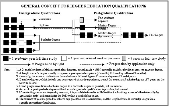
Figure 1 - Distinguishes between undergraduate and post-graduate
qualifications and outlines a general concept for the Bologna Agreement,
modelled on the existing Irish situation.
Some national professional associations in western and central Europe are
beginning to perceive the Bologna Agreement as a threat to the high quality
of their existing qualifications at MSc. level, and the high standard
required for membership. This feeling is compounded by the EU's notion that
a professional is someone with a 'BAC + 3' qualification, when the reality
is something quite different. The introduction of many bachelor degrees will
generate a lively debate on what practically constitutes a professional. An
investigation in this regard in Belgium is suggesting that the technical
grade in surveying will comprise graduates with bachelor degrees and the
professional grade will comprise graduates with master's degrees. The debate
on the issue of what constitutes a professional is of prime importance, and
should be discussed by national and pan European professional associations
as a matter of urgency. I would suggest that a threshold of four or five
years most likely at master's degree level might be the most appropriate for
geodetic surveying.
It is very important that academic institutions firstly communicate with
industry and the national professional associations before any bachelor
degrees are introduced. We do not want to have a situation whereby academic
institutions are producing graduates on the false assumption that a bachelor
degree will qualify the graduates for membership of national associations or
access to appointments which were previously reserved for graduates with
master's degrees.
The European Commission carried out a review of the Sectoral and General
Directives during the latter half of 2000 due to a perception that little
progress has been made implementing procedures for mutual recognition of
qualifications since the Directives were introduced. The adoption of the
Commission communication on the future of the mutual recognition of
professional qualifications has now been put back to spring 2001, however
sources suggest that the Commission does not envisage proposing any change
in the 'BAC + 3' threshold at this time.
Conclusions
The primary objective of the Bologna Agreement was to establish and
promote the European system of higher education world-wide. This will only
be successful if the basic underlying principles for education promoted in
Europe are of a sufficiently high standard. There is a danger that the BAC +
3 threshold set by the EU is too low as a basic professional qualification
and that the quality of existing European qualifications will be eroded,
thus hindering the overall objective of the European Ministers of Education.
CLGE has identified the need for a high level education, preferably a
master's degree for European geodetic surveyors, which should be broad based
to undergraduate level, and specialisation should only be introduced at
post-graduate level. Curricula should contain a significant element of
measurement science supporting a substantial understanding of land
administration management and geographic information management.
While it has not been possible for CLGE to produce a core syllabus, as
was originally intended, we believe that we have made a significant
contribution in highlighting some of the important issues, along with
funding research to increase our knowledge in some areas. Curricula must be
flexible to provide the skills necessary for a rapidly changing marketplace,
but overall guiding principles and policies are necessary to ensure
graduates have the competencies to solve the challenges they will meet in
their careers.
CLGE does not consider this report to be the final answer, but only the
beginning of a process to investigate and debate these issues more widely,
and to provide us with the knowledge to allow us choose good policies for
the future of our profession. I suggest that the issues of "Educational
Reform due to the Bologna Agreement" and "What constitutes a
professional" are the next most important issues requiring
investigation and debate for geodetic surveyors in Europe.
References
Allan, A. (1995): The Education and Practice of the Geodetic Surveyor in
Western Europe, CLGE Report 3rd edition, pp 1-159. UK.
Dale, P. (2000): ISO/TC211 or "A Different Route",
GeoInformatics,
Volume 3, No. 7, pp 38. The Netherlands.
European Council, (1988): COUNCIL DIRECTIVE (89/48/EEC) on a general system
for the recognition of higher-education diplomas awarded on completion of
professional education and training of at least three years' duration,
Official Journal of the European Communities, No. OJ L 019, pp 0016-0023.
Belgium.
European Council, (1992): COUNCIL DIRECTIVE (92/51/EEC) on a second general
system for the recognition of professional education and training to
supplement Directive 89/48/EEC, Official Journal of the European
Communities, No. OJ L 209, pp 0025-0045. Belgium.
European Ministers of Education, (1999): The European Higher Education Area
- Joint Declaration of the European Ministers of Education, Bologna
Agreement June 1999, pp 1-3, Belgium
FIG Commission 4 on Hydrography & The International Hydrographic
Organisation, (1997): Standards of Competence for Hydrographic
Surveyors,
International Hydrographic Organisation, 8th Edition, pp 1- 26. UK.
Maher, R. (1998): Geographic Information/Geomatics - Qualifications and
Certification of personnel, International Standards Organisation Technical
Committee 211 Geographic Information, PT 19122, N 573, http://www.statkart.no/isotc211/protdoc/211n573,
Canada.
Prendergast, W. P. (1999): National feedback to the Discussion Document on
CLGE Strategy for the Future, CLGE General Assembly Vienna October 1999, pp
1-10. Ireland.
Acknowledgements
I would like to give a special word of thanks to all the CLGE delegates
and the surveying academics from Europe who attended the joint FIG / CLGE
Seminar in Delft in November 2000 who painstakingly corrected the
information and provided suggestions for the table included in the appendix.
Finally, I would like to specially thank Stig Enemark for his assistance and
co-operation arranging the first joint FIG / CLGE seminar on this important
subject.
Biographical Notes
W. P. Prendergast (Paddy) is a lecturer in the Dept. of Geomatics, Dublin
Institute of Technology, Ireland. His main academic interest is the
structure and visualisation of spatial data and he is currently completing a
PhD in Trinity College Dublin on visual assessments conducted during
environmental impact assessments in Ireland. He previously worked in
Ordnance Survey Ireland as a military officer on their digital mapping
programme throughout the 1980's and early 1990's as part of their senior
management team. He has been actively involved in the development of the
geodetic surveying profession in Ireland during the last decade and is the
current President of the Irish Institution of Surveyors (IIS). He has also
been the President of CLGE since 1998.
Merging the Efforts of CLGE and FIG to Enhance Professional Competence
Prof. Stig Enemark
Introduction
FIG, short for Federation Internationale des Geometres, or International
Federation of Surveyors in English, is the umbrella organisation for
national associations of surveyors world wide, representing all surveying
disciplines. Nearly 100 countries are represented in FIG covering a total of
about 230,000 surveyors world wide.
FIG is a UN-recognised non governmental organisation (NGO) and its aim is
to ensure that disciplines of surveying and all who practice them meet the
needs of the markets and communities that they serve. It realises its aim by
promoting the practice of the profession and encouraging the development of
professional standards. Educational development and enhancement of
professional competence are core issues in this regard. FIG has established
working parties on educational issues and currently a Task Force is
undertaken in the area of Mutual Recognition.
The seminar in Delft was about paving the way to enhancement of
professional competence. This issue is seen as ideal for merging the efforts
of CLGE and FIG.
Issues such as curricula development, quality assurance, and continuing
professional development are crucial to any professional organisation at
national regional or international level. The issues become even more acute
when looking at the challenges facing the surveying profession. Some of
these challenges are due to evolution of technology and some are due to
institutional changes as a consequence of political and economical
development in individual countries. Developments in technology and
institutional frameworks may provide new opportunities for the surveying
profession, but they will also be the destroyers of some professional work.
The challenges of the so-called information age will be to integrate modern
surveying technology into a broader process of problem solving and decision
making. We must assess carefully what range of skills will be required of
those entering, and continuing within, the modern occupational world of
surveying.
There is no doubt that the main challenge of the future will be that the
only constant is change. To deal with this constant change the educational
base must be flexible. The graduates must be adaptable to a rapidly changing
labour market. The point is, that professional and technical skills can be
acquired and updated at a later stage in ones career while skills for
theoretical problem-solving and skills for learning to learn can only be
achieved through the process of academic training at the universities.
Universities should focus on educating for life, not for short term skills.
Development, maintenance and enhancement of professional competence should
be seen as a total process facilitated through an efficient interaction
between education, research and professional practice.
International Trends in Surveying Education
Management skills, versus specialist skills. The changes in the surveying
profession and practice and especially the development of new push button
technologies has voiced the need for including the core discipline of
management as a basic element in today's surveying education. Traditional
specialist skills are no longer sufficient or adequate to serve the client
base. Surveyors need to have the skill to plan and manage diverse projects,
including not only technical skills, but those of other professions as well.
In short, the modern surveyor has to be capable not only of managing within
change but managing the change itself.
Technological developments take the skill out of measurement and the
processing of data. Almost any individual can press buttons to create survey
information and process this information in automated systems. In the same
way, technological developments make GIS a tool available to almost any
individual. The skill of the future lies in the interpretation of the data
and in their management in such a way as to meet the needs of customers,
institutions and communities. Therefore, management skills will be a key
demand in the future surveying world.
Project organised education, versus subject based education. An
alternative to traditional subject-based education is found in the project
organised model where traditional taught courses assisted by actual practice
are replaced by project work assisted by courses. The aim of the project
work is "learning by doing" or "action learning". The
project work is problem-based meaning that traditional textbook knowledge is
replaced by the necessary knowledge to solve theoretical and practical
problems from the society/reality. The aim is broad understanding of
interrelationships and the ability to deal with new and unknown problems.
In general, the focus of university education should be more on
"learning to learn". The traditional focus on acquisition of
professional and technical skills (knowing how) often imply an
"add-on" approach where for each new innovation one or more
courses must be added to the curriculum to address a new technique. It is
argued that this traditional subject-based approach should be modified by
giving increased attention to entrepreneurial and managerial skills and to
the process of problem-solving on a scientific basis (knowing why).
Virtual academy, versus classroom lecture courses. There is no doubt that
traditional classroom lecturing will be supported by or even replaced by
virtual media. The use of distance learning and the www tends to be
integrated tools for course delivery, which may lead to the establishment of
the "virtual classroom" even at a global level. This trend will
challenge the traditional role of the universities. The traditional focus on
the on-campus activities will change into a more open role of serving the
profession and the society.
The computer cannot replace the teacher and the learning process cannot
be automated. However, there is no doubt that the concept of virtual academy
represents new opportunities especially for facilitating for process of
learning and understanding and for widening the role the universities. And
the www techniques for course delivery on a distant learning basis represent
a key engine especially in the area of lifelong learning programmes.
The role of the universities will have to be reengineered based on the
new IT-paradigm. The key word will be knowledge-sharing. On-campus courses
and distant learning courses should be integrated even if the delivery may
be shaped in different ways. Existing lecture courses should always be
available on the Web. Existing knowledge and research results should also be
available, and packed in a way tailored for use in different areas of
professional practice. All graduates would then have access to the newest
knowledge throughout their professional life.
Lifelong learning, versus vocational training. There was a time, when one
qualified for life, once and for all. Today we must qualify constantly just
to keep up. It is estimated that the knowledge gained in a vocational degree
course has an average useful life span of about four years. The concept of
lifelong learning or continuing professional development (CPD) with its
emphasis on reviewing personal capabilities and developing a structured
action plan to develop existing and new skills is becoming of increasing
importance. In this regard, university graduation should be seen as only the
first step in a lifelong educational process.
The challenge of the new millennium will be to establish a new balance
between the universities and professional practice. This new balance should
allow the professionals to interact with the universities and thereby get
access to continual updating of their professional skills in a lifelong
perspective.
The only Constant is Change
A recent survey of the surveying profession in Denmark may be used as a
case study to illustrate this constant change.
The professional profile of the Danish surveyor is a combination of
technical, judicial and design areas. The profile thus is a mix of an
engineer, a layer and an architect. The professional fields then consist of
three areas: surveying and mapping, cadastre and land management, and
spatial planning. Cadastral tasks are the monopoly of licensed surveyors in
private practice, and the role of this private surveyor (measuring and
wearing green rubber boots) has traditionally epitomised the Danish
surveyor. However, the structure of the surveying profession and the profile
of the Danish surveyor are both turned upside down through the latest two or
three decades.
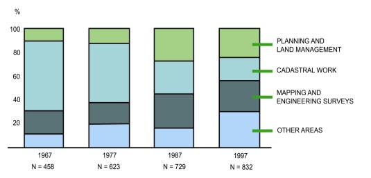
Since the late 1960´s the Danish Association of Chartered Surveyors has
carried out a survey of the surveying profession every 10 years starting in
1967. The changes taken place over these 30 years and especially over the
latest two decades are quit remarkable. The evolution of surveying
profession in Denmark is shown in the figure below.
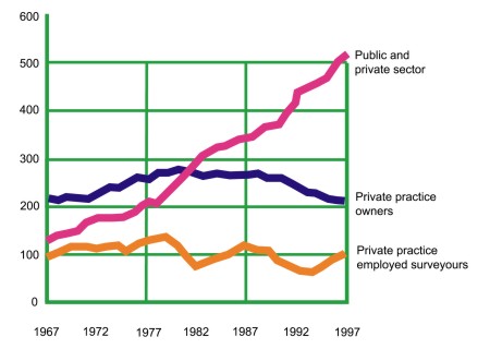
In 1967 the number of surveyors working in the private surveying firms
accounted for about two thirds of the total profession while surveyors
employed in the public sector or in other private business accounted for
only one third. In 1997 the situation is reversed. Two thirds of the
profession is employed outside the private surveying firms. During these 30
years the number of active surveyors is doubled from about 450 in 1967 to
about 850 in 1997. This means that the growth is located within the
surveyors employed in the public sector or other private business while the
number of surveyors working in the private surveying firms has been more or
less steady during the last 30 years.
Over the same period, the professional profile has changed completely. In
1967 and still in1977 the profile of the Danish surveyor was dominated by
the cadastral area while in 1997 it accounts for only 20 percent of the
total working hours. In 1997 the distribution was as follows: Planning and
Land Management 23 %, Cadastral Work 20 %, Mapping and Engineering Surveys
26 %, and "Other Areas" 31%. Next to the decrease in the cadastral
area it is remarkable that the biggest area in 1997 is located outside the
traditional working areas. These "other task areas" include
general management, general IT-development, and other business developments.
The evolution of the professional profile in Denmark is shown in the diagram
below.
The changes shown above are significant and must of course be reflected
in content and structure of the educational base. In fact, the changes have
been coped with rather easily within the profession and also with regard to
the labour market. It is likely to assume that this is due to the flexible
and project organised educational model introduced in 1974 when the
surveying programme was moved from the Royal Veterinary and Agricultural
Academy in Copenhagen to a new university established in Aalborg. It is also
likely to assume that without a flexible educational base being focused on
the concept of learning to learn rather than teaching disciplines, and
without the deriving adaptability of the graduates being suitable for a
changing market, the surveying profession would have faced some heavy
problems.
The Educational Challenge
The developments as discussed above have a significant educational
impact. There is a need to change the focus from being seen very much as an
engineering discipline. There is a need for a more managerial and
interdisciplinary focus. The strength of our profession lies in its
multidisciplinary approach.
Surveying and mapping are clearly technical disciplines (within natural
and technical science) while cadastre, land management and spatial planning
are judicial or managerial disciplines (within social science). The identity
of the surveying profession and its educational base therefore should be in
the management of spatial data, with links to the technical as well as
social sciences.
The universities should act as the main facilitator within the process of
forming and promoting the future identity of the surveying profession. Here,
the area GIS and, especially, the area managing geographical and spatial
information should be the core component of the identity. This
responsibility or duty of the universities, then, should be carried out in
close co-operation with the industry and the professional institutions.
The challenge of the future will to implement the new IT-paradigm and
this new multidisciplinary approach into the traditional educational
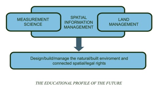
programmes in surveying and engineering. A future educational profile in
this area should be composed by the areas of Measurement Science and Land
Administration and supported by and embedding in a broad multidisciplinary
paradigm of Spatial Information Management. Such a profile is illustrated in
the figure below.
Professional Competence
The term professional competence relates to a status as an expert. This
status cannot be achieved only through university graduation and it cannot
be achieved solely through professional practice. University graduation is
no longer a ticket for a lifelong professional carrier. Today one must
qualify constantly just to keep up. The idea of "learning for
life" is replaced by the concept of lifelong learning. No longer can
"keeping up to date" be optional, it is increasingly central to
organisational and professional success.
The response of the surveying profession, and many other professions, to
this challenge has been to promote the concept of continuing professional
development (CPD) as a code of practice to be followed by the individual
professionals on a mandatory or voluntary basis. Maintaining and developing
professional competence is of course the responsibility of the individual
practitioner. This duty should be executed by adopting a personal strategy
which must be followed systematically. Implementation of such a plan,
however, relies on a variety of training options to be offered by different
course providers, including the universities.
The individual practitioner should be able to rely on a comprehensive CPD
concept which is generally acknowledged by the profession and which is
economically supported by the industry (public as well as private).
Furthermore, the practitioner should have a variety of training and
development options available for implementation of his or her personal plan
of action. The options should be developed by the universities offering for
example one-year masters courses as part time studies based on distance
learning; and also by private course providers offering short courses for
updating and just-in-time training. These options should be developed in
co-operation between the universities, the industry and the professional
associations.
Furthermore, the individual practitioner should be able to rely on a
comprehensive concept for getting his or her professional competence
recognised in a regional and global context. There is an attraction in
developing and extending such a principle of Mutual Recognition of
Professional Qualifications. Mutual recognition allows each country to
retain its own kind of professional education and training because it is
based, not on the process of achieving professional qualifications, but on
the nature and quality of the outcome of that process. In turn this should
lead to enhancement of the global professional competence of the surveying
profession. And the national associations as well as the universities should
play a key role in facilitating this process.
In short, enhancement of professional competence relies on an efficient
interaction between education, research and professional practice. To
facilitate this interaction is the true challenge of the new millennium.
References
Colemann, D.J. (1998): Applied and Academic Geomatics into the
Twenty-First Century. Proceedings of FIG Commission 2, The XXI International
FIG Congress, pp . Brighton, UK.
Enemark, S. (1997): The Role of the Universities in Provision of Continuing
Professional Development. AUSM Journal on Land Information Systems, Vol.57,
no 3, pp 194-197. USA.
Enemark, S. (1999): Landinspektorundesogelsen 1997 (A Survey of the
Surveying Profession 1997). The Danish Journal for Mapping and Land-Use,
Vol. 39, pp 434-448. (Only in Danish).
Kennie, T. and Enemark, S. (1996): Continuing Professional Development and
its future Promotion within FIG. FIG publications no 16.
Kjersdam, F. and Enemark, S. (1994): The Aalborg Experiment - Project
Innovation in University Education. Aalborg University Press.
Biographical Notes
Prof. Stig Enemark is Head and Managing Director of the Surveying and
Planning School at Aalborg University, where he is Reader in Cadastral
Science and Land Management. He is Master of Science in Surveying, Planning
and Land Management and he obtained his license for cadastral surveying in
1970. He worked for ten years as a consultant surveyor in private practice.
He is Vice-President of the Danish Association of Chartered Surveyors. He
was Chairman (1994-98) of FIG Commission 2 (Professional Education) and
since 1998 he has been Chair of the FIG Task Force on Mutual Recognition. He
is an Honorary Member of FIG. His teaching and research interests are in the
land policy area including cadastre, land administration systems, land
management and spatial planning. Another research area is within project-organised
educational and the interaction between education, research and professional
practice. He has consulted and published widely within these topics, and
presented invited papers at more than 40 international conferences.
Rob Ledger
Abstract
The CLGE working group on recognition of qualifications proposed the
concept of a core syllabus in European geodetic surveying to encourage a
higher and more relevant common standard of education and to facilitate the
mobility of professional surveying labour around Europe. This paper explains
why the group feels that this approach may not be suitable for the entire
European geodetic surveying sector due to cultural and market diversity.
Introduction
In the spring of 1998, the CLGE established a working party to explore
the value of a core syllabus for geodetic surveying in Europe. The initial
objectives of the project were to explore how a core syllabus could
"... help employers and those offering contracts to accurately
evaluate surveyors with qualifications from other European
nations"..."
and how it could
"... shorten the process that a surveyor must complete in order to
qualify to practice in another European nation with a restricted
profession".
The original output of the working party (CLGE, 1998), presented at the
FIG Brighton Congress in July 1998, suggested that a core syllabus could
help to facilitate these objectives.
The work of the group over the following two years has now concluded that
the creation of a core syllabus is neither the answer to bringing about
mutual recognition, nor to enhance professional competence across the entire
European geodetic surveying sector. The group believes that the cultural and
market diversities that exist across Europe, and also within geodetic
surveying itself, mean that a core syllabus could only be useful within
certain homogeneous sub-sections of the profession.
This paper explains how these conclusions have been reached, and why the
objectives of the overall project have subtly changed, now to be
encouraging:
Evidence and arguments to stimulate improvement of curricula in order to
assist the convergence of standards across Europe, and,
Information to assist the determination of equivalence of qualifications
to facilitate the mobility of professionals between countries.
Diversity within the European geodetic surveying profession
For a core syllabus to be worthwhile, it relies upon a certain level of
commonality across its area of coverage. This commonality must be present
not just in the subject areas being taught, but also in the academic and
professional framework in which the students are participating. Even if it
were possible to identify a set of core subjects in which it was felt to be
important for all geodetic surveyors to have a minimum level of competence,
it would still be a separate task to work out how that level of competence
could be attained in different educational systems, and how it could be
certified, if at all.
This section looks at both the diversity in the market for surveying
services, and the cultural diversity of educational systems across Europe.
Market Diversity
The subjects that are covered by a course must primarily reflect the
areas of knowledge required by the markets that employ surveying graduates.
The problem comes where these markets require different areas of competence,
both in the technical subjects in which a graduate must be capable, and also
in terms of the business and ethical competencies that they need to show.
Furthermore, these market requirements are not static. As time passes,
the geodetic surveying market evolves, and courses must adapt their emphases
to produce graduates capable of meeting current and future market demands.
There are a number of characteristics of the European geodetic surveying
market that show how significant market diversity is as a barrier to a core
syllabus.
The definition of a surveyor is a prime example. Various attempts have
been made to define what makes a surveyor (see FIG, 1991), and in an attempt
at being more specific, the European Geodetic Surveyor (CLGE, 1997). It is
suggested though, that an attempt to compare national customary
understandings of the terms "surveyor", "land surveyor",
or "geodetic surveyor" against these global or regional
definitions would result in some quite major discrepancies.
One reason is that certain tasks that are a surveyor's job in one country
are part of another professional's remit elsewhere. Where spatial planning
is the work of a surveyor in many parts of Europe, some countries have
developed an independent profession for spatial planners and although the
new profession interacts with surveyors, planning is seen as a separate
discipline.
Another reason is that some areas of surveying are not practised at all
in certain countries. Sometimes this is for historical reasons, but it is
often equally true in emerging markets where a country has not yet developed
the economic need for a particular surveying service. Cadastre is a prime
example of a branch of surveying that is vitally important to most national
surveying professions, but for historical reasons is not practised in a
small number of countries including the UK. While cadastre would have to be
a compulsory and a large part of the education of many European geodetic
surveyors, it is only taught as an optional subject on most UK courses,
intended for the currently small number of graduates who choose to explore a
career abroad.
The above two issues still cause a problem where they exist to a lesser
degree, i.e. where surveyors do actually pursue a certain area of practice,
but only as a minor part of their business. Many course providers will
choose not to offer that subject as part of their training as they feel that
demand will be low in comparison to the other subjects fighting for space in
their curriculum.
Cultural diversity
Leaving aside the problems concerning the diversity of the markets in
which surveying services are offered, there is an equally large issue of
contrasting educational models.
The CLGE working party found very early on it it's discussions that a
core syllabus would struggle to overcome two major issues in European
education.
The first issue concerns teaching methods, and can be described as the
input versus output approach. The second issue involves the method by which
a learning provider is able to declare that it is producing graduates with a
certain level of competence. This may be thought of as self-assessment
versus accreditation.
Input versus output approach
The initial CLGE paper from the working party (CLGE, 1998) suggested that
a core syllabus could be created which would contain a range of subjects
that should be taught, along with a measure of how much time as a minimum
should be devoted to each subject.
This approach was viewed favourably by a number of European nations,
typically those in the South of the region. For many though, the idea of
basing a syllabus on what should be presented to students was felt to be
inappropriate. Denmark, for example, wanted the emphasis to be placed on the
competence with which a student graduated rather than the specific content
that they had been taught.
It became clear that a system that proposed one method or the other for
influencing course content would almost certainly be ignored as unworkable
by a large proportion of the intended academic market.
Self-assessment versus accreditation
A similar cultural diversity exists in the way that academic achievement
is perceived by those in industry and the wider profession.
The working party initially suggested a method of accrediting those
universities that delivered courses based upon the core syllabus, involving
some sort of awarding body with the authority to say whether a course was
suitable or not.
This model is very similar to that operating in countries including the
UK where the country's professional body, the Royal Institution of Chartered
Surveyors, judges courses against a number of criteria before deciding
whether to offer accreditation and therefore a route to professional
qualification for its graduates.
Again this model was found to be unacceptable in a number of European
countries, where a scheme of self-assessment is more normal. Under this
system, it is for the university to decide whether its graduates meet a
certain standard, and the market is left to determine whether the
university's claim is credible. If graduates are at a lower standard than
expected, employers will quickly make this clear to the university that
trained them.
The contrast in the two systems is a result of a difference of
inter-relationship between industry, the profession, government and academia
in those countries. The factors that influence the content of courses vary
in importance across Europe. In some countries, the job market is the
driving force of course content. In other areas, professional accreditation,
or government funding may be more of an issue.
Cultural and market diversity leads to curricula diversity
The issues of cultural and market diversity raise three issues then for a
core syllabus:
- Can a core syllabus be created that covers all the important subjects to
be learned by surveying students, without imposing unnecessary learning on
students of any particular region or specialism?
- If a core syllabus can be defined in terms of subject area, is there a
model by which it can actually be delivered to students?
- How can the market or the profession judge whether students are
graduating with appropriate levels of competence?
Having raised the potential difficulties with these issues as expressed
earlier in this section, the working group were asked to investigate whether
the creation of a core syllabus would be possible across geodetic surveying
in Europe, in effect judging whether market diversity was too large or not.
The working group needed to determine somehow which subjects should be
contained in all course syllabuses. The initial approach taken was to study
which subjects were currently being taught by a sample of universities as
part of their geodetic surveying courses. The group would then need to
decide which subjects being taught reflected what should in fact be taught
by everyone.
The group pursued the first step by initially studying the syllabuses of
geodetic surveying courses from six countries around Europe. The study also
included a comparison of the syllabuses of seven courses from the UK to
examine specialist rather than regional focus.
The study was limited in the sense that certain universities were more
forthcoming than others in the amount of syllabus detail that they provided,
but it still gave a strong indication that much diversity exists.
Within the UK, there was a distinct division between the contents of
traditional "land surveying" courses and those focused on
geographical information science. Where the former all considered geodesy,
engineering surveying, physics, mechanics and instrumentation to be
essential, the GI courses preferred to include computer science, software
development, and data management. The subjects common to all courses were
limited to topographic surveying, statistics, photogrammetry and remote
sensing. A core based on these common subjects within the UK would be
extremely limited in its use. This is hardly surprising, as the expected job
profiles of the graduates from these courses are very different, despite all
falling within the definition of geodetic surveying.
Comparing course content across Europe also showed significant diversity.
Cadastre was again a prime example of a subject fundamental to the syllabus
in many countries, yet completely absent in others.
What emerges is that there are certain groups of countries that have
quite similar educational content, based on the fact that they have
comparable markets for surveying services. Parallels can be drawn between
course content within Germany, Austria, Switzerland and France, countries'
whose liberal professions show strong similarities. The UK and Ireland also
appear to offer similar content to students, reflecting two surveying
markets quite close in their demands on skills.
It might be a more practical starting point for developing core
syllabuses for groups of countries with similar market demands rather than
the diverse European market. Indeed if these groups with common market
demands also have less of a cultural diversity in terms of education and its
relationship with the profession and industry, they would appear to be well
suited to greater co-ordination in their learning systems. Whether smaller
sub-sections of the European geodetic surveying market working together to
define standards is beneficial to Europe as a whole is a question for
further investigation.
How can the original objectives be facilitated?
The core syllabus project started out by trying to research how the
profession across Europe could facilitate two things:
- To aid the mobility of geodetic surveyors around Europe by providing a
mechanism for understanding qualifications from other education systems.
- To minimise the adaptive process that a migrant surveyor would need to
make, by encouraging all universities to provide geodetic surveying students
with a core level of competence in a set of defined subjects, transferable
across the whole of Europe.
Whilst the working group has come to the conclusion that a European core
syllabus is not the answer to meeting these goals, the goals themselves are
still extremely valid. The group agreed that more research was needed in two
areas:
Evolution of curricula in recognition of market demand
Instead of defining what subjects are important to be included in all
surveying courses, it may be more productive to acknowledge market diversity
and to recognise that the issue for course providers is how they can deliver
a course to meet a particular market demand. If market demand differs around
Europe and even within single countries, each course will need a slightly
different approach and type of content.
A gap between market demand and academic supply could be caused by a lack
of understanding of how to meet that demand. To assist in overcoming this
gap, research is needed into how successful surveying courses have evolved
their content and delivery to provide graduates with the skills and learning
ability that the market requires. This type of information should be a
valuable resource for universities looking to evolve their courses in the
right direction. Professor Hans Mattsson addresses this issue in his paper
"The Education and Profession of Land Surveyors in Western Europe"
(Mattsson, 2000).
Mutual Recognition
To gain a better understanding of how qualified a surveyor is to practice
in another country, it should not be a simple case of comparing academic
qualifications. While it is undoubtedly important to understand what a
graduate has learnt as part of their degree course, it is more useful to
potential employers and those offering recognition to a migrant to
understand the individual's overall professional competence. A surveyor's
ability to work as a professional depends not just on their technical
competence but also on their business experience, their ethical standards,
and a number of other less obvious factors. Dr Frances Plimmer looks into
this matter in her paper "Professional Competence Models in
Europe" (Plimmer, 2000).
Conclusions
For a core syllabus to succeed in leading a profession towards a high
common standard of education and simpler transferability of labour across
borders, there needs to be a relatively high level of commonality within not
just the areas of competence that the market demands, but also in terms of
education systems, and the inter-relationship between education, industry,
the profession and government.
The CLGE working party on recognition of qualifications believes that
this level of commonality is not present across the whole of the European
geodetic surveying sector. There is significant diversity in market demand
for surveying services, not just across Europe but also within individual
countries. There is a divide in how courses are delivered, and also in how
they are recognised as achieving a certain standard.
To enable courses to evolve their content to meet European market demand,
it is suggested that more information should be published on how successful
courses change their focus and content to reflect market changes.
To facilitate mutual recognition of qualifications, the profession should
work towards a clearer understanding of professional competence and how it
can be compared across borders.
References
Ledger, R. (1998): Discussion on the Development of a Core Syllabus for
European Qualifications in Geodetic Surveying, CLGE Discussion Paper for FIG
Congress in Brighton, pp 1- 22, UK.
Mattsson, H. (2000): The Education and Profession of Land Surveyors in
Western Europe, CLGE - FIG joint Seminar at the Delft Technical University,
pp 1-5, The Netherlands.
Plimmer, F. (2000): Professional Competence Models in Europe, CLGE - FIG
joint Seminar at the Delft University of Technology, pp 1-7, The
Netherlands.
Stannard, J. (1996): The Establishment of the Profile and Definition of the
Geodetic Surveying Profession to meet the Requirements of the General Public
and the Commission of the European Union, CLGE, pp 1-33, UK.
The International Federation of Surveyors, (1991): Definition of a
Surveyor,
FIG Bureau, Publication Number 2, pp 9, Finland.
Biographical Notes
Rob Ledger is the Head of New Media at the Royal Institution of Chartered
Surveyors (RICS) in London. A qualified land surveyor, he was previously in
charge of Geomatics at the RICS. Rob has until recently been one of two UK
delegates to the CLGE, leading the Council's working party on the
recognition of qualifications and competencies.
|