History of Surveying and
Measurement
|
Arc measures
In this context, by arcs is meant
sections of lines of latitude or longitude, or sometimes lines oblique to
the main lines, that have been accurately measured at some time in the past
for use in determining the size and shape of the earth or as part of a
national mapping framework.
A list of these, together with some of
their attributes is being compiled by J R Smith.
The lines usually covered one or more
degrees of latitude (or longitude) with some stretching for over 25 degrees.
Among those of note are:
-
The arc
by Eratosthenes c 230 BC
-
The arc
by the Chinese 724 AD
-
The arc
by the Arabs 820 AD
-
The first
by triangulation - Snellius in Holland 1615
-
The arc
by Abbé La Caille in South Africa 1751
-
The arc
through India from north of Sri Lanka to the foothills of the Himalayas
of 1800-1840
-
The arc
from near North Cape in Norway to the Black Sea of 1816-1855
(= the Struve arc)
-
The arc
along the border between Sweden and Finland of 1737
-
The arc
along the mountain summits of Ecuador (Peru in those days) of 1736-1744
-
The arc
through France 1795-1798 (for the determination of the metre)
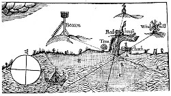 |
From Geodaesia or the Art of Surveying. J
Love. 1768. Courtesy Jan de Graeve. |
Bibliography
See for example:
From Plane to Spheroid. Determining the figure of the Earth from 3000 BC to
the 18th century Lapland and Peruvian survey expeditions. J R
Smith. 1986. Landmark Enterprises, California. ISBN 0-910845-29-8
A Calendar of Surveying. A P H Werner Australian Surveyor. Series of
parts Sept. 1966-June 1968.
Colonel Sir George Everest, CB, FRS, (1790-1866) a celebration of the
bicentenary of his birth. Royal Geographical Society, London 1990 ISBN
0-85406-478-8
Everest. The Man and the Mountain. J
R Smith. 1999 Whittles Publishing. ISBN 1-870325-72-9
Erdgestalt, Kosmologie und Weltanschauung. V Bialas. Konrad Wittwer.
1982 ISBN 3-87919-133-6
|


