News
 |
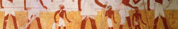
Work of Surveyors,
Metro Station in Moscow.
Courtesy Grahame Lindsay. |
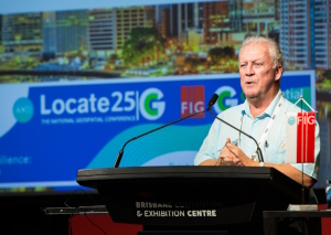
New Director
At the General Assembly 2025 in
Brisbane, Australia Mr Jan De Graeve announced that he wanted to step down
as Director of IIHS&M after his many years in the chair. Jan De Graeve was
thanked by FIG President Diane Dumashie for his long-term engagement and
outstanding contribution to the History of Surveying. His latest
accomplishment was a 7-volume book on the History of Surveying, written
together with Jim Smith, also a long term contributer of the FIG Permanent
Institution. It is still possible to secure of of the special 100 copies of
this amazing work on the History of Surveying.
Read more here
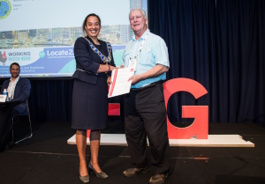
FIG General Assembly 2025 appointed Mr John Brock new
Director of IISH&M
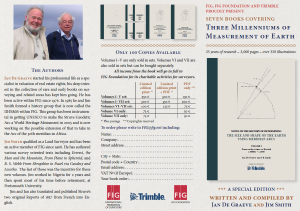
The History of Surveying - Secure your special edition set
7 volumes covering Three Milleniums of Measurement of Earth
35 years of research - 3,000 pages - over 350 illustrations
|
These seven books include a life-long research and work of
Jim Smith and Jan De Graeve on the History of Surveying. Only a
100 Special Edition Sets of the seven volumes are currently
being printed
Jim and Jan presented the books at FIG
General Assembly session 4 on the Work of FIG
The section on the History of Surveying begins at the time
1:06:00 starting with an introdcution by FIG Vice President
Mikael Lilje. |
More information and how to reserve your copy of this special
edition
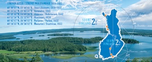
UNESCO World Heritage Meeting - Struve Arc. 11 May 2016
Chair of the Permanent Institution, Jan de Graeve participated in the
meeting on the Struve Arc on 11 May 2016.
Special Stamps to commemorate the Struve Meridian Arc
FIG Permanent Institution on History has worked to promote the
positive image of the surveying profession and has introduced the Struve
Meridian Arc at the World Heritage List of UNESCO. The Struves Arc has now
been introduced on special stamps in both Finland, Sweden and Latvia. The
Swedish stamp has a portrait of W. Struve and theodilite. The Latvian stamp
is also showing a portrait of Struve and theodolite with triangulation of
Lativa and market stone. The Finish stamp is shown above.
In Estonia, the Observatory of Tartu (central point of the struve
Meridian Arc) has been restaured and officially opened by the president of
Estonia on 27 April 2011. Together with surveyors from many countries, FIG
was represented by Jan de Graeve, president of the IHHSM.
Read more about Struves Meridian Arc in
FIG
Publication no 50
History at NOAA (National Oceanic & Atmospheric
Administration, USA)
If you have an interest in the history of the American Coast and Geodetic
Survey, there are many aspects of this on-line at
http://www.history.noaa.gov/.
Also there is a book on the early years of the Coast Survey on-line at
http://www.lib.noaa.gov/edocs/CONTENTS.htm
An autobiography titled "Earth Measurer" at
http://www.history.noaa.gov/cgs_stories.html
refers to a well known American surveyor/geodesist Aslakson.
http://www.history.noaa.gov/stories_tales/ak1.html has various Personal
Stories.
At
http://www.history.noaa.gov/stories_tales/jlawson.html is the
autobiography of James Lawson in Western Tales.
In the NOAA Photo Library there are sections devoted to the history of
the Coast and Geodetic Survey at
http://www.photolib.noaa.gov/collections.html (check Sailing for
Science, Geodesy, and Historic Coast and Geodetic Survey Albums) and there
are a number of images from our Rare Books Collection of the NOAA Central
Library including various surveying instruments in the Treasures of the
Library Album.
|
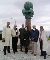 |
On the weekend of 16–18th June ten countries in Europe marked the
occasion of 34 triangulation points of surveying importance being
accepted by UNESCO for inscription on the World Heritage List.
In Norway the official gathering took place at the meridian monument
at Fuglenes in the city of Hammerfest in the county of Finnmark.
Professor Jan De Graeve from Belgium and Honorary Secretary of
the International Institution for the History of Surveying and
Measurement, Jim Smith from England, were guests of honour.
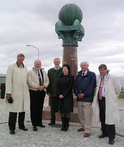
Head of Norwegian Mapping and Cadastre Authority Mr
Knut Flåthen (left), Professor Jan De Graeve, Mr Bjørn
Geirr Harsson, the Norwegian Minister of Fisheries and Costal
Affairs Helga Pedersen, Honorary Secretary Mr Jim Smith,
and the Mayor of Hammerfest Mr Alf E. Jakobsen. |
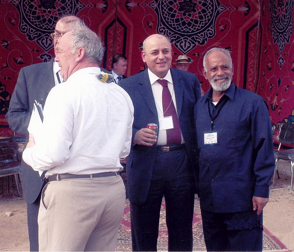
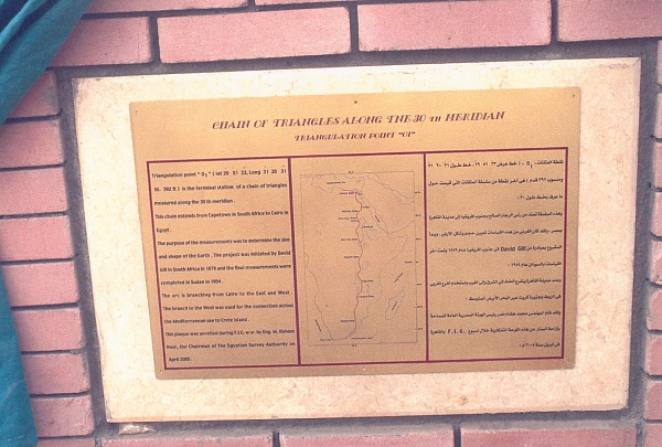
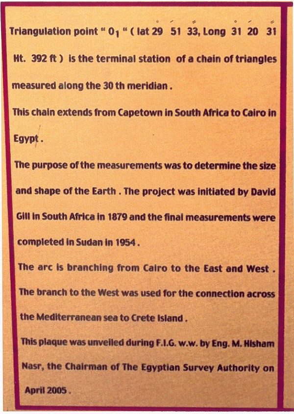
International Institution for the History of Surveying and
Measurement at the FIG/GSDI Conference in Cairo, Egypt 16-21 April 2005
The International Institution for the History of Surveying and
Measurement held a
one-day workshop on the 16th of April at the FIG/GSDI Conference in
Cairo, Egypt 16-21 April 2005. During the conference also the plaque at the
end of the 30th Arc was unveiled in Cairo on the 18th of April 2005.
Proposal to UNESCO for the Struve Geodetic Arc to become a
World Heritage Monument
On 28 January 2004 a dossier, together with a letter from the Finnish
Minister of Culture, Mrs Tanja Karpela, was submitted to the World
Heritage Committee of UNESCO for the possible inscription of selected
surviving survey stations of the Struve Geodetic Arc as a World Heritage
Monument. This was done by the Government of Finland on behalf of the
Governments of the ten countries through which the meridian arc passes, i.e.
the Governments of Norway, Sweden, Finland, Russia, Estonia, Latvia,
Lithuania, Belarus, Moldova and the Ukraine representing their National
Survey Departments. In FIG the International Institution for the History of
Surveying and Measurement - an Organisation within the FIG has been very
active in this process.
The Struve Geodetic Arc was measured over the 40 years from 1816 to 1855
and stretches from Fuglenaes near North Cape in Norway (latitude 70º 40’11
N) to near Izmail on the Black Sea (latitude 45º 20 03 N). A distance of
2820 km or 25º 20 08 of arc. In longitude the 265 stations lie between 22º
30 and 30º E.
Actually 34 of the surviving station marks have been selected for the
present submission and these lie in ten different countries in today’s
geography. The idea to seek a declaration to preserve a selection of the
remaining Struve Arc points as a World Heritage site was originally
presented by Aarne Veriö at a Scientific Conference in Tartu in 1993
where a Resolution was made. A corresponding Resolution proposed by Seppo
Härmälä was then made at the FIG Congress in Melbourne in 1994 and the
work to get all the necessary material together from these countries was
initiated by Jan de Graeve and Jim Smith of the I.I.H.S.M. It
gathered pace during the latter five years particularly with the help of
Vitali Kaptjug from Russia. For the last 1½ years the Survey of Finland
under Surveyor General Jarmo Ratia and his colleague Pekka Tätilä
took over the task of assembling, collating, checking and reproducing all
the documentation for the final submission document. However the whole
project would not have been possible without the exceptional and unstinting
support of the survey organisations and appropriate government departments
in all the countries named above.
It is understood that it might be June 2005 before a decision is known
but aside from that the project has graphically illustrated how surveyors
and their political masters across ten countries can cooperate on a scheme
of this sort. In fact it is the first such multi-country, cross border
submission of a project and of a scientific nature which in itself meant
that there was little by way of a precedent to follow.
As the first multi-country meridian arc it was a great step forward and
it was not initially planned as one system. F G W Struve was working
to the north whilst initially unbeknown to him a Russian military officer
Carl F de Tenner was operating in a similar manner to the south. When it
was decided to link up it was not a simple case of observing a common
triangle as there were problems of reconciling two different units of
measurement, the different instrumentation used and the political goodwill
between the countries involved.
In the late 1800s David Gill in S Africa was starting out on a
similar arc that would eventually go from Buffelsfontein near Port Elizabeth
right through E Africa to near Cairo. He had the notion that this arc could
be connected to that of Struve and produce one arc of 105º length or over 11
500 km. He was of the opinion that Struve’s son Otto had already
extended the Arc of his father and Tenner to Crete but to date only details
of the reconnaissance can be found, nothing to say that the work was
actually carried out.
The preservation of these selected points will assist future generations
to monitor the evolution of the geoid on which we live.
J R Smith
Contact addresses for further details:
Prof. Jan De Graeve, Tel. +32(0)2268 1025
Mr Jim Smith, e-mail
jimsmith1780@gmail.com
Mr Pekka Tätilä, e-mail
pekka.tatila@nls.fi
 Press
release in .pdf-format.
Press
release in .pdf-format.
Struve Arc 150
|
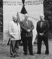
Prof. Jüri Randjärv, Jan de Graeve and Jim Smith at the Struve
monument outside Tartu Observatory.
|
From 25 to 28 September 2002 the
Association of Estonian Surveyors, Estonian Land Board, Estonian
Agricultural University and Tartu University held a conference in
Tallinn and Tartu on “Struve Arc 150”. 50 delegates from 10 countries
attended- namely Norway, Sweden, Finland, Russia, Estonia, Latvia,
Lithuania, Belarus, Ukraine, Moldova, Belgium and UK. Essentially it was
commemorating the 150th anniversary of the completion of the Struve
Geodetic Arc that ran from near North Cape in Norway to the Black Sea,
but was an ideal opportunity to discuss the arc in detail and to
progress the efforts of the International Institution for the History of
Surveying & Measurement to have selected points in each country
recognised by UNESCO as a World Heritage Monument. |
13 of the 15 technical papers were published in a special
booklet. In addition to the technical presentations the group visited the
remaining Struve survey stations marking the terminals of the Simuna
baseline and the starting point of the whole arc in Tartu (formerly Dorpat)
observatory. At the latter point the Rector of Tartu University, Professor
Jaak Aaviksoo, unveiled a special plaque at the point set by Struve
on the meridian through the observatory. Four resolutions were passed, see
attached report.
History of Surveying on web of Czech Technical University in
Prague
Web pages of group of engineering surveying courses ensured by Faculty
Civil Engineering - Department of Special Geodesy
were created in frame of educational grant of Czech Technical University in
Prague number CTU 02 15511. Address of English version of elective course
History of Surveying is
http://gama.fsv.cvut.cz/~hanek/DEJZ/EN/ and it
offers two texts, which have been already published in English and German.
These texts are focused on manufacturing of surveying instruments in Czech
lands from the 16th century to half of the 20th century.
There are also about one hundred photographs of exhibits and their basic
specification from documentation catalogue of successful exhibition
„Surveying Instruments in Czech Lands“. This exhibition was organised by
National Technical Museum with assistance of Czech Union of Surveyors and
Cartographers on the occasion of standing committee session of International
Federation of Surveyors in Prague „FIG Working Week Prague 2000“.
Reprint of The Compleat Surveyor by Leybourn (first
published in 1653)
Now available for US$50, orders to W Robillard, 1601 Berkeley Lane NE,
Atlanta, GA, USA 30329, email:
robw@mindspring.com
More information about The Compleat
Surveyor, download here as .pdf-file.
THE COMPLEAT SURVEYOR William Leybourn 1657
The International Institution for the History of Surveying & Measurement
(a permanent body within FIG) is proud to announce its 2nd publication of a
reproduction of an important surveying text of the 17th century. The
Compleat Surveyor was first published in 1653 printed by
E & W Leybourn for E Brewster and G Sawbridge and was a
folio edition (Wing L 1907). The second edition of 1657 is a more
attractive volume and is 28.0 x 18.0 cm. Further editions appeared in 1674,
1679 and 1722.
William Leybourn (1626-1719) (alias Oliver Wallingby) started as a
printer before working as a land and quantity surveyor. He was one of the
surveyors of London after the great fire of 1666 where he associated with
Robert Hooke. He was very influential in his profession and was often
employed on the survey of the estates of gentlemen. In 1649 with Vincent
Wing he wrote the first book in English on astronomy - Urania Practica.
Leybourn's book remained one of the standard treatises throughout the
second half of the 17th century and the early years of the 18th, combining
the necessary mathematics with a practical description of surveying
instruments and their use. The book had an extraordinary popularity during
that period and is rather well illustrated. This reproduction is authentic
in that all pages were scanned by the latest technology, with side notes
retained. A high quality paper commensurate with the original, except in
thickness was used in its reproduction. The cover is a simulated leather
binding, similar to the original.
The full title of the 1657 edition is :
"The COMPLEAT SURVEYOR: containing The Whole Art of Surveying of Land, by
the Plain Table, Theodolite, Circumferentor, Peractor and other
instruments: After a more easie, exact and compendious manner, then hath
been hitherto published by any: the Plain Table being so contrived, that it
alone will conveniently perform whatsoever may be done by any of the
fore-mentioned Instruments, or any other yet invented, with the same
ease and exactness; and in many cases much better.
Together with the taking of all manner of Heights and Distances, either
accessible or in-accessible, the Plotting and Protracting of all manner of
Grounds, either small Inclosures, Champion Plains, Wood-lands, or any other
Mountainous and un-even grounds. Also, how to take the Plot of a whole
Manor, to cast up the content, and to make a perfect Chart or Map thereof.
All which particulars are performed three several ways, and by three several
Instruments.
Hereunto is added a new way of Surveying of Land, by which a man may be
satisfied whether his Plot will close before he begins to protract the same,
with the manner how to order such Water Colours as are necessary for the
beautifying of Maps and Plots; Also how to know whether Water may be
conveyed from a Spring-head to any appointed place or not, and how to effect
the same: With whatsoever else is necessary to the Art of Surveying."
In addition to The Compleat
Surveyor he published a large series of books on land surveying or
dialing including:
-
Planimetria or the Whole Art
of Surveying. 1650
-
Arithmetic, vulgar decimal,
instrumental and algebraical 1657, 1678
-
The Art of Numbering 1667
-
The Line of Proportions 1667,
1678 and 1684
-
The Art of Dialing, performed
geometrically 1669, 1681 and 1700
-
Introduction to Astronomy and
Geography 1669
-
Nine Geometrical Exercises.
1669
-
Panorganon. 1672
-
The Use of the Semi-Circle in
the Surveying of Land. 1673
-
Astroscopion, two large
celestial hemispheres. 1673
-
A Treatise of Navigation.
1674
-
An appendice containing the
Use of all the Instruments. 1678
-
Dialing plain concave and
convex 1682 and 1700
-
In this book is added Francis
Hall's Description of the Sundials of White Hall's Gardens
-
Cursus Mathematicus. The
Matematicall sciences in 9 books. 1690
-
Pleasure with profit. 1694
-
Mathematical Institutions.
1704.
This reproduction of the 1657 edition has been printed for the
International Institution for the History of Surveying & Measurement as a
means to acquire funds to progress its activities. In particular it is at
present involved in the preservation of selected surviving survey points of
the Struve geodetic arc, observed during the first half of the 19th century,
as an UNESCO International Heritage site. The site of this spans 10
countries and stretches for some 2880 kms from North Cape to the Black Sea.
It is hoped to be able to conclude the case to UNESCO during the coming
year.
Contact address for enquiries regarding The International Institution for
History of Surveying & Measurement is: J R Smith
24 Woodbury Ave
Petersfield, Hants GU32 2EE
UK
Tel/fax +44 (0)1730 262619
E-mail jimsmith1780@gmail.com
A few copies still remain of Geodaesia by John Love, 1688 - the first
book on Surveying in the USA - at US$50. To obtain either, or both,
volumes:
Please supply ........ copies of The Compleat Surveyor 2nd Edn. by W
Leybourn at a cost of $50 per copy plus post & packing.
Please supply ......... copies of Geodaesia by John Love at a cost of $50
per copy plus post & packing.
Name and address
..............................................................
..................................................................................
Payment can be by cheque or check, payable to Walter Robillard- Book
Account or American Express, Visa or Master Card credit card or FAX order to
404-248-1464 or e-mail to
robw@mindspring.com
Orders to W Robillard, 1601 Berkeley Lane NE, Atlanta, GA, USA 30329
Surveying and Mapping the Americas, proceedings of symposium at FIG
XXII Congress, Washington, DC, April 2002
Exhibition at the
FIG Congress in Brighton in 1998
The exhibition
that was mounted for the FIG Congress in Brighton in June 1998 is now
available on CD ROM. It is hoped that particularly national survey
associations/professional bodies/ history groups and others will purchase
this ROM so that the exhibit can be printed off and displayed around the
world. Enquiries to
WallisConsult@compuserve.com. The exhibit contains 154 images on 43
panels. The panels are best if reproduced to around a metre square.
Publications
-
Everest. The Man and the Mountain. J R Smith. 1999 Whittles Publishers. 320 pages. £37.50 ISBN 1-870325-72-9
-
With Compass and Chain. Early American Surveyors and Their Instruments.
S Bedini.2001. Professional Surveyors Publishing Company Inc. 774 pages.
ISBN 0-9665120-0-6
-
The Writings of the Roman Land Surveyors. B Campbell. 2000. Soc. For Promotion of Roman Studies.
London. 570 pages. ISBN 0-907764-28-2
-
Drawing the Line. How Mason and Dixon surveyed the most Famous Border in
America. E Danson. 2001. Wiley,
New York. 232 pages. ISBN 0-471-38502-6
-
Time Lord. Clark Blaise. 2000. A A Knopf, Canada.
256 pages. ISBN 0-676-97252-7
Contact:
J R Smith
24 Woodbury Ave
Petersfield
Hants GU32 2EE
UNITED KINGDOM
Tel and Fax + 44 (0)1730 262 619
jimsmith1780@gmail.com
|