Article of the Month -
March 2009
|
A Status Report of the Activity of the Survey of Israel
Dr. Haim SREBRO, Israel
 This article in .pdf-format (27
pages and 2,7 MB)
This article in .pdf-format (27
pages and 2,7 MB)
1) This paper has been prepared for
presentation at the FIG Working Week 2009 in Eilat, Israel, 3-8 May
2009.
Key words: Survey of Israel, Geodesy, Cadastre,
Geo-Information, NSDI, Geo-Portal, Survey regulations, CORS, Undulation
Model, Coordinate Based Cadastre, 3D Cadastre, Mapping, Hydrographic
Charting.
ABSTRACT
The Survey of Israel (SOI) is a Government Agency, under the Minister
of Construction and Housing, operating since 1948 and is the successor
of the British Survey of Palestine that was established in 1920. SOI
employs today a staff of 250 government employees and 50 additional
staff.
SOI is the national organization responsible for licensing, directing
and inspecting surveyors, for definition the professional policy and
regulations and for creation and maintaining the national infrastructure
in geodesy, cadastre, mapping and geo-information.
During last years SOI is undergoing a fast upgrade of its
technological environment and its activities and services.
This paper elaborates on the current status of the activities of the
Survey of Israel in the various fields of its responsibilities.
This includes geodesy, cadastre and geo-information as well as
regulation of the profession.
The author serves as the Director General of the Survey of Israel.
1. GENERAL OVERVIEW
The Survey of Israel (SOI) is a government agency under the Minister
of Construction and Housing operating since 1948 and is the successor of
the British Survey of Palestine that was established in 1920. SOI
employs today 250 government employees and 50 additional staff.
SOI is the national organization responsible for licensing, directing
and inspecting surveyors, for defining the professional policy and
regulations and for the creating and maintaining the national
infrastructure in geodesy, cadastre, mapping and geo-information.
During last years SOI is undergoing a fast upgrade of its
technological environment and its activities and services.
The main generators of these changes are the need for improvement of
effectiveness and the necessity for improvement of service. The
processes leading to the changes are connected to the macro economical
changes, leading to decrease of government employees and privatization
of activities, so that most of the production is outsourced. The changes
depend on the technological advancement and on the changing needs of the
public who requires better accessibility to information and services and
availability on-line.
In parallel to sharp decrease of manpower SOI integrated new
technologies in the fields of Geodesy, Cadastre and Geo-Information. As
a complementary activity SOI prepared new regulations fitting the
present status of technologies and the direction of future development.
These regulations are now in a legal process before publication.
Meanwhile professional directives for surveyors were published by the
Director of SOI.
The Survey of Israel (SOI) is a governmental agency responsible for
four basic areas (see Figure 1):
- Responsibilities with regard to the surveying profession,
surveying regulations, professional guidelines of the director,
licensing of surveyors, inspection and enforcement and promotion of
the profession; research and development; international boundaries
and international relations.
- Geodesy, including the geodetic network.
- Cadastre, including regional offices.
- Mapping and geospatial data and services, including hydrographic
charting; national archives of maps and aerial photographs.
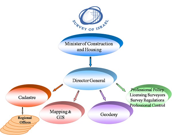
Figure 1: SOI responsibility
The traditional geodetic infrastructure in Israel consisted of a
network of tens of thousands of triangulation points and hundreds of
thousands of control points. These control points were constructed and
surveyed since 1920 when the Survey of Palestine was established by the
British Mandatory regime (see Figure 2). The traditional geodetic grid
used to be the Israeli grid, which was based on the Palestine Grid. In
1995 this grid was replaced by the New Israeli Grid, based on additional
survey and triangulation (Adler and Papo, 1984).
Horizontal network
Vertical Network
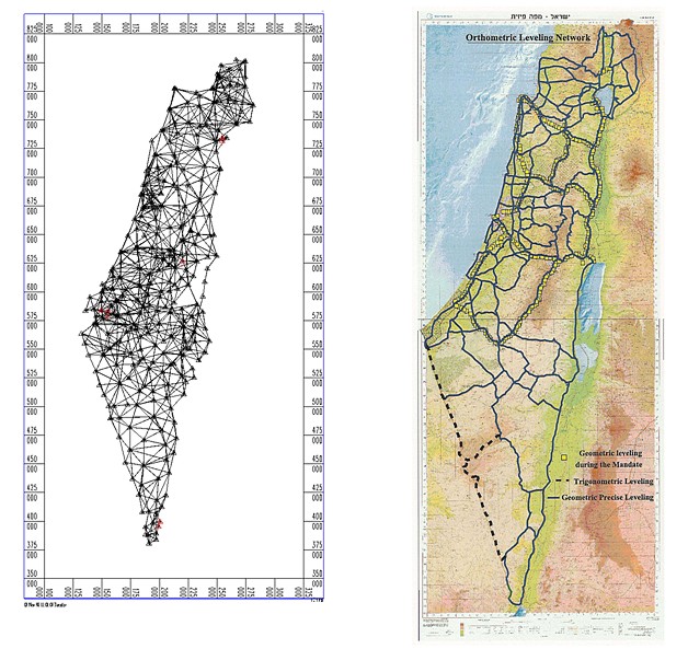
Figure 2: The Traditional Horizontal and Vertical Networks
The Israeli cadastre was established in 1928 and is based on Torrence
principles. As for today, more than ninety five percent of Israel
already went through the basic process of land settlement. In addition
to the slow advancement in the settlement process of the rest of the
lands due to complicated land claims, most of the cadastral activities
include re-parcelation due to economical activities and land development
and preparation of mutation plans (Mutation plans are prepared in land
settled areas which following re-planning of the area, require
unification of blocks or parcels and new subdivision of parcels which
fits the new plan. Mutation plans are prepared by surveyors and approved
for registration by SOI). These activities require the control and
certifications of the SOI for land registration. Since all the
professional documents and data are managed by the SOI, the private
surveyors, who took over the traditional job of the government surveyors
in preparation of blocks and plans, are required to visit physically the
archives of the SOI in order to look for old data, including hard copy
block plans, field sheets and field books, or in order to acquire data
from the geodetic and cadastral digital data base of the SOI.
This process requires a lot of time, both of the surveyors and of the
government employees. In addition, the quality of the hard copy
materials continues to deteriorate and surveyors face unavoidable
problems of inaccurate data due to low quality and due to
inconsistencies in traditional data. These problems resulted in slowing
the process of survey and preparation of land mutations, including the
process of control and evaluation of the mutation plans. Thus,
influencing the process of land development as well as causing long
delays in land registration.
In spite of the high quality of the traditional SOI maps, the
national GIS database at the SOI was developed from 1:40,000 aerial
photographs since 1991. This has caused problems of compatibility
between the GIS and the hard copy maps, as well as problems of parallel
investment in updating the two systems. Customers were required to come
to the SOI in order to purchase data from the National GIS. The selling
models were rigid and not user friendly. This did not satisfy the
dynamic developing GIS markets and especially the needs of the location
based services industry. This situation was counter productive in spite
of the recognition of the customers of the high quality of SOI data.
The requirement of the market, including the private market, the
government and the public, led SOI to the understanding that there
should be a major change towards better response to user requirements.
The result of this understanding was to change products, to increase
the variety of products, to update the databases more frequently and
make data available to users faster, preferable on line. In addition,
there was a requirement to improve accuracies.
Other results were: to adopt most advanced technologies, to change
the production processes and to shorten the production times; to define
or adopt standards and specifications for data transfer and for digital
products; to improve quality control and data management; to improve the
availability and accessibility of data services to the users, either
internal or external, and to define new models of service.
The leading requirement and basis for integrated geospatial
management is to handle the geospatial information on the basis of
accurate coordinate based reference. Technology enables this process,
and a new geodetic network which is based on satellite permanent
stations (APN-Active Permanent Network) was established.
2. NATIONAL GEO-INFORMATION CONSULTING AND REGULATION OF THE
PROFESSION
The Director General of SOI is responsible for licensing surveyors. A
license will be granted for people meeting the following requirement:
graduating from a four year geodetic, engineering accredited program,
two years of guided experience and special competency exams.
SOI is responsible for the preparation of professional regulations to
be signed by the Minister according to the Survey Ordinance which has
been the basis of the legislation since 1929 under the British Mandate.
These regulations contain information about geodetic networks,
surveying, cadastral and mapping procedures.
The Director General (DG) of SOI publishes professional directives to
surveyors to update and augment the regulations and to deal with
changing technologies. In addition SOI publishes standards and
specifications, to be used by surveyors with regard to additional
professional activities, including GIS and hydrographic charting. These
standards also implement international standards like ISO and IHO. Part
of these standards are taken care by the DG of SOI in his assignment as
the chairman of the Governmental Inter-Agency Committee for GIS.
The traditional responsibility with regard to the regulation of the
profession is characterized by preparing new regulations to cope with
the changing technologies, managing the practice of new surveyors and
licensing surveyors. During the last decades, survey regulations were
published every decade. The last version was published in 1998. The 1998
regulations, focused on the transition to the New Israeli Grid,
requiring every surveyor to tie every survey to this grid. Since 1998
the Director General is publishing guidelines (directives). These
guidelines include the direction to tie every new control point to
Israeli Grid 2005 which is based on the Active Permanent stations (APN).
A new version of regulations is in process (Steinberg G., 2006).
The new regulations deal with geodesy, cadastre and mapping. The
basic part concentrates in geodesy to support both the cadastral
activities as well as engineering and topographic surveying.
The regulations for geodesy deal with the horizontal and vertical
control networks, boundary surveying and measurement of features and
heights.
The horizontal network, required mainly to serve the cadastre, is
aimed towards the achievement of 5cm accuracy (with 95% reliability).
This will be based on the new Israeli Grid 2005 (IG05).
The vertical grid is supposed to supply a framework of a precise
network for engineering and topographic surveying.
Due to the unjustified need for investment in orthometric precise
leveling, the required precision for 1st order vertical control as
specified in the regulations was not achieved. As a result of this fact
the team, working on the new regulations, decided to abandon the goal of
high accuracy in the national vertical network, and to leave the precise
vertical network to the municipal and local level.
The new regulations discontinued the requirement for the maintenance
of the national orthometric network and replace it by an ellipsoidal
network, based in part on the control stations of the horizontal
satellite geodetic network, which serve as a three dimensional network.
The transformation from ellipsoidal to orthometric heights is
specified in the guidelines of the DG of SOI. This is based on a
statutory model of undulations.
The new cadastral regulations aimed at serving a goal that was
specified by the Director of the Survey of Israel to advance practically
and gradually towards a coordinate based cadastre in Israel. One step in
this direction is the definition and a preliminary approval of an
external boundary. Another important step is the definition and approval
of a boundary plan which is not registered at the land registry but is a
formal document.
Additional regulations deal with the transition of coordinates due to
the new grid IG05, reconstruction of boundaries, computerized
preparation of land settlement blocks, 3D cadastre etc.
With reference to the mapping regulations the DG of SOI directed the
preparation team to change the concept of the regulations due to the
fast changes in technology and to base the new regulations on standards
of products and not on techniques and technologies.
SOI has responsibilities regarding the international boundaries of
Israel. Its staff participated in the boundary demarcation of the
international boundaries between Israel and Egypt and Israel and Jordan.
The DG of SOI is a co-chair of the Israeli-Jordanian Joint Team of
Experts taking care of the boundary issues. This includes the maritime
boundaries as well.
SOI has been always supporting legislation regarding planning and
construction, land settlement and land registration. During the last
decade SOI supports legislation regarding the protection of the
environment. One of the examples is the definition of the coastlines
along the Mediterranean Sea, along the Red Sea and along the Sea of
Galilee for the protection of the coastal environment (see Figure 3)
(Srebro, 2008). Other examples refer to the protection of mature trees,
to 3D planning etc.
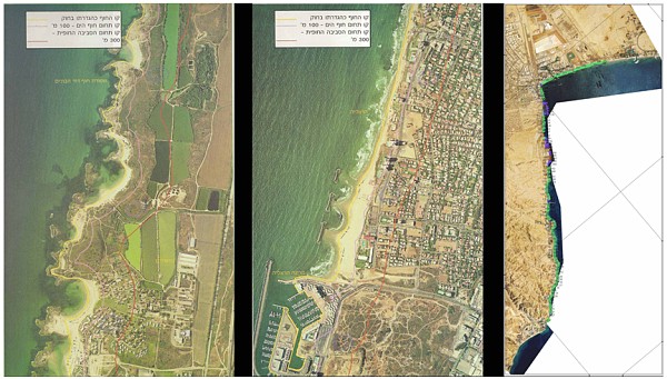
Figure 3: Examples for the Definition of the Coast line for the
Protection of the Coastal Environment.
SOI is in charge of national R&D regarding its areas of
responsibilities and for domestic and international relations, including
with the Academy, to achieve its goals.
This includes monitoring the sea levels, monitoring the magnetic
field etc. as well as cooperation with the Geological Survey of Israel
(GSI) and with the Israel Oceanographic and Limonological Research
Institute (IOLRI) and other organizations in exploring the marine
bathymetry (see Figure 4).
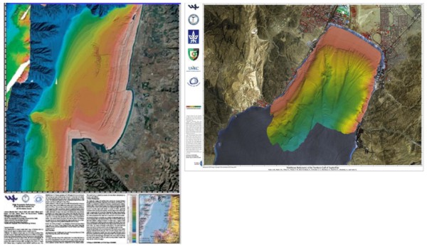
Figure 4: Bathymetric Mapping, Examples of Cooperation with GSI
and Other Organizations.
3. GEODESY
The geodetic infrastructure in Israel consists of the horizontal
network and vertical network. Both were based traditionally on
development, enlargement, densification and enhancement of the geodetic
infrastructure of the British Mandate, which was constructed since 1920
in the northern part of Israel.
The horizontal network consisted of tens of thousands of control
points of various precision grades. The highest precision of the Major
triangulation points was at the level of 1:50,000 to 1:100,000. The
triangulation network was re-measured. The survey included angles and
distances and Laplas azimuths and the triangulation was readjusted to an
accuracy of 1:250,000.
The vertical network, consisted of geometric leveling, expect the
south western part of the deserted Negev which was measured by
trigonometric leveling. In the unpopulated areas, mainly in the south,
the leveling loops were very wide, bridging over unsurveyed areas. The
accuracy of the bench marks of this network is in the range of 3mm to a
kilometer.
During the last decade a new horizontal network was established on
the base of the Active Permanent Network. This Network entered into
force by the DG of SOI by publishing formal guidelines to surveyors. The
accuracy of this network is in the level of 1-2 centimeters.
The core of this network consists of 19 Continuously Operating
Reference Stations operated by SOI (see Figure 5). Most of the stations
work both with GPS and GLONASS satellites. This improves the effective
coverage of the existing stations, especially for RTK (Real Time
Kinematic) mode of service. In addition to RTK the permanent stations
provide also VRS (Virtual Reference Stations) service for post
processing and DGPS service.
The importance of the combination of GPS and GLONASS and in the
future GALILEO, when this will be possible, will increase in a few years
when the expected receiving conditions will decrease.
This service is supplied to surveyors with no restrictions, using
various models of payment either by subscription or per use.
The revenues do not cover the full cost of the maintenance of the
APN.
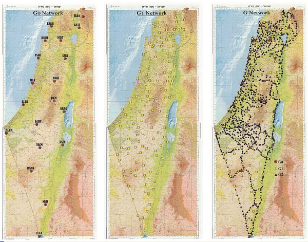
Figure 5: The New Horizontal Network
The permanent stations are the nucleus of the current Israeli
geodetic grid, called ISRAEL GRID 2005 (IG05), (Steinberg G. and Even
Tzur G., 2005).
The new grid consists on three components:
- G0 – The Active Permanent Network (19 stations).
- G1 – 150 stable control stations constructed in cooperation with
the Geological Survey of Israel, (GSI) used originally for
monitoring the geodynamic movements of the earth. These stations are
measured periodically (every 5 years since 1997) with reference to
G0 stations. The third round of measurements was conducted in 2008.
SOI is considering adding 40 additional control stations which were
constructed lately by the Geological Survey of Israel for monitoring
the movements along the Afro-Arabian Rift. The advantage of this
cooperation is the stability of the constructed control stations
which are drilled sometimes to a depth down to 12m.
- G2 – 1,500 control points measured with reference to G0 and G1
stations. These points were measured during the last years and serve
actually as a three dimensional network.
These points define the formal national geodetic reference system,
and are of highest accuracy.
Additional control points will also be incorporated in the new
geodetic data base. These are control points measured by private
surveyors and controlled and certified by the SOI. They are denoted as
S1 and S2 points. These points will be considered at lower quality than
the main points (G0, G1 and G2). In spite of that, even the accuracy of
the lower quality control points (S1, S2) is higher than the accuracy of
the traditional (readjusted) Major triangulation points.
In addition to the new network a series of professional guidelines
were published by the DG of SOI in the interim phase before new
regulations are prepared and enter into force.
The traditional vertical control system is based on a network of
benchmarks measured by precise geometric leveling. The requirement in
the regulations for a 1st order orthometric control network is 2mm √Lkm.
This is not achieved and the requirement for the maintenance of unstable
benchmarks is too high.
SOI supplies a national orthometric vertical network of 3rd level to
which the local authorities tie their local vertical network.
The accuracy of this network is 15mm/km which supports a basic
national network. Local islands of vertical networks of benchmarks, with
better accuracies, which are prepared by local authorities, are tied to
the national network in the limited level accuracy of 5-10cm.
In order to optimize the investment in the maintenance of the
vertical orthometric network, SOI decided to implement an ellipsoidal
vertical network, based on 700 control points measured by precise
leveling as well and with reference to the APN of which the G0 stations
have 5mm vertical accuracy, G1 points have 10mm vertical accuracy and G2
points have 20mm vertical accuracy.
An innovative approach was implemented in the professional guidelines
for the vertical reference based on implementing a statutory undulation
model (Steinberg G. and Even-Tzur G., 2006).
The undulation model which was developed in SOI (IsraeL Undulation
Model – ILUM) using a network of 840 points which have orthometric
heights and which were measured by GPS measurements and have ellipsoidal
heights in ITRF2000. The density in the north is high but in the south
the loops are wide confining large empty areas of low accuracy.
The absolute accuracy of the model is better than 10cm in most of the
areas except where the density and homogeneity of the orthometric and
the ellipsoidal bench marks are low. The use of the model for
transformation of ellipsoidal heights to orthometric heights supports
accuracies of 3-18cm, but its relative accuracy is better than 25 ppm.
The rate of undulation in Israel relatively to the reference
ellipsoid WGS84 is in the range of 24m in the north to 17m in the south
(Even Tzur G. et al., 2006). The maximum inclination of the ellipsoid
relatively to the Geoid in Israel is 14cm to 1km in the area of the Dead
Sea (see Figure 6).
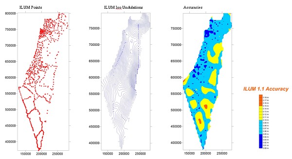
Figure 6: Vertical Network – The Undulation Model
4. CADASTRE
Until 1928 the cadastral system in Israel used to be the Ottoman
deeds system. The owners were registered and the transactions were
recorded. In 1928, under the regime of the British Mandate, this was
changed to a register of properties following the Torrence principles.
The state guarantees the record of the title.
The guarantee of the State is made by two state agencies:
- The Survey of Israel is responsible for the verification and
approval of the correctness of the plan.
- The Register at the Ministry of Legal Affairs is responsible for
the registration and for management of the land records.
The land settlement, which began in 1928, covers today about 95% of
the State of Israel. This includes about 16,000 live blocks (see Figure
7). Additional few thousand blocks were canceled during the years and
replaced by other blocks. These blocks contain 800,000 parcels. More
than half of the country, mostly in the unpopulated south, is divided to
wide blocks containing one to several parcels. These are state owned
lands.
The annual rate of progress of the land settlement is around 200 new
blocks, while the expected volume to accomplish the land settlement is
3,000 new blocks. There are initiatives to accelerate the process,
especially in the area of the Bedouins in the south, in order to
reconcile frictions and disputes.
During the British Mandate the land settlement was executed by
government employees, the surveyors of the Survey of Palestine. This
used to be the situation also after the independence of the State of
Israel until about thirty years ago. Today the preparation of block
plans and mutation plans is executed by private surveyors and the
verification and approval for registration is done by SOI.
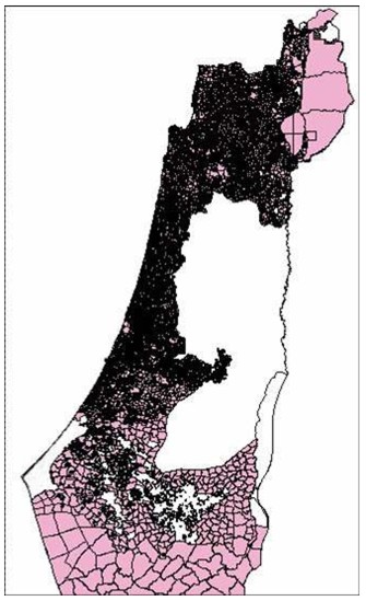
Figure 7: The Land Settlement in the North of Israel
Most of the activities in the cadastral area refer to mutation plans.
The fast accelerated development of the State of Israel, growing from a
population of around one million people 60 years ago to more than seven
million people today, is reflected in the growing rate of mutation
plans. The annual number of mutation plans which has to be verified and
approved by SOI is 1200-1450 plans.
The current status of the cadastral activities includes a
computerized environment of the land survey and office work for the
production of the mutation plans. The historical archives are partly
computerized and the management of the cadastral data base is integrated
in a cadastral GIS which serves the requirements of management. Since
most of the data of the traditional block plans was digitized from the
graphic hard copies it is not accurate enough for the registration
itself. The field survey is performed by private surveyors, who have to
come to one of the SOI offices in order to assemble the required
reference data, and in order to get confirmation for the specific
produced control points.
In addition to the approval of the control points, an approval of the
mutation plans is required as well. Two major measures were taken during
the last years for acceleration of the control and approval of the
mutation plans. One measure was internal, including a development of a
unified overall command and control system (Forrai J. et al., 2004 and
2008). This command and control system is important in order to unify
the procedures, since there used to be a wide variance between the
requirements of the different district offices. Thus, the private
surveyors complained that they have to adapt their plans to the district
offices. In addition the administrative management in part of the
offices was manual. The new system directs the supervising surveyors
throughout SOI, including the district offices, to unify their
requirements from the surveyors. It unifies the inspection procedures
and automates the administrative management to better control the
overall activities, enabling flexibility in sharing tasks and tracing
and improving the overall efficiency. This accomplishes the
standardization of the surveying procedures which had been implemented
for years and the resulting files as well.
The other measure was external, refers to outsourcing the assessment
and confirmation of mutation plans by nomination of supervising
surveyors (Forrai J. and Kirschner G., 2009) to cover up to now third of
the annual amount of mutation plans. This step of granting authority to
external supervising surveyors happened to be a great success. In 2008
the throughput of these supervising surveyors was around 400 mutation
plans which was almost one third of the overall production (Forrai J.
and Kirschner G., 2009). This external activity, which had components of
competition with the internal supervision had a positive influence on
the internal work and improved the internal efficiency as well. As a
result, 2008 was the first year for many years that the overall output
of certified mutation plans was bigger than the number of new plans.
As an improvement to the original plan, two of the external
supervising surveyors were granted permission to supervise mutation
plans of their colleague supervising surveyors. As a result of this
success a new bid is published for an additional 5 years term of
supervising surveyors with improvements resulting from lessons learned.
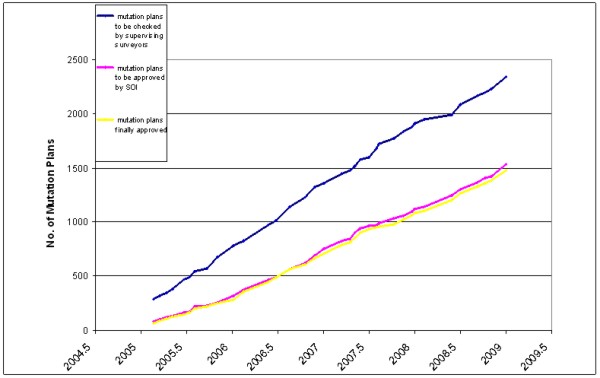
Figure 8: The Production of the Supervising Surveyors.
In addition, first functions of direct access of the public to
cadastral managerial data were launched successfully using the internet,
referencing blocks and parcels to addresses and supplying historical
data of blocks.
A few projects were executed in order to progress toward a digital
coordinate based spatial cadastre. These projects include 3D cadastre
projects. The accelerated development in Israel, especially in the
center and the north, which are densely populated, require a practical
and legal solution, which will enable registration in three dimensions,
both under and above the ground. A R&D 3D cadastre comprehensive project
was conducted (Shoshani U. et al., 2004), followed by a few
implementation projects, required for planning multi-dimensional sites.
These projects include the following cases: Accommodation sites and/or
commercial complexes above or beneath archeological sites, underground
traffic tunnels and interchanges. The suggested solution included
preparation of the multilayer cases for spatial land registration. The
planning, the management and the land registration in these cases should
be handled on a coordinate based reference, usually on a GIS platform.
The result of the R&D project introduced a comprehensive solution,
defining sub division of spatial sub parcels. In the future this should
expand also to the management of changes in the dimension of time (see
Figure 9).
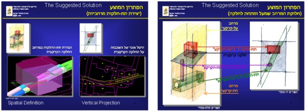
Figure 9: 3D Cadastre.
For the time being only few special cases are taken care of with
cooperation between the Survey of Israel, the Land Management Authority
and private surveyors. Up to date the results enable potential 3D
registration, but this is not implemented yet because the legal
arrangements are not prepared yet. Therefore these projects are taken
care only from the technical point of view, planning, engineering,
geodesy and management.
There is a wide understanding that an accurate coordinate based
cadastre (CBC) should replace the existing hard copy map based cadastre.
This understanding is shared by the three components of the professional
community in Israel: The Survey of Israel, the academy and the private
surveyors. A CBC would contribute to handling lands as a commodity in
the commercial market. It would accelerate the registration process,
increase the precision of land management and reduce friction and
disputes which lead to courts.
The current geodetic infrastructure based on the APN supports a CBC
enabling real time and high accuracy. The required legal effort is
challenged especially because of the problem of differences between the
registered parcel areas and the accurate parcel areas, as computed from
the coordinates. This is relevant to property rights and requires legal
solutions. But there is an option to accomplish most of the migration
from the hard copy database to a coordinate based database without the
registration itself. This will enable a surveyor, who prepares a new
mutation plan, to refer to the coordinates and just to check for the
existence of authentic points in the area, saving him the current
requirement to look for old hard copy files and to execute a
complicated, time consuming, research. The biggest challenge of
migration from the old hard copy to CBC is the certainty of
reconstruction of the original boundaries. For this purpose there is a
significant importance to the identification of old authentic points,
either control points or physical stable constructions. These authentic
points contribute to the accuracy of the transformations. The changes of
coordinates and areas, which result of the improvement of accuracy due
to the use of modern technologies, can be taken care better than those
which result of mistakes of reconstruction of original boundaries.
Due to the high cost of the project of transforming legacy cadastral
data into CBC a few feasibility studies were carried out as well as an
economic assessment.
The economical assessment showed high revenue in such a project. The
feasibility projects showed a requirement for different approaches in
different areas like state owned open and unpopulated areas,
agricultural areas, areas with low populated density and areas with high
population density. The fastest and cheapest areas to take care of are
state owned, unpopulated lands, where it is easy for the state to change
limits and areas. The most complicated areas are private owned or leased
areas in the cities, where the economic significance of any change may
be dramatic. In addition, the pilot projects showed the importance of
locating and surveying old authentic points which disappeared due to
accelerate development and are required as anchor points for future
transformations.
As a result of the pilot projects, SOI is leading an effort of
transforming around two thirds of the lands which are state owned
unpopulated or sparsely populated lands. This should be a relatively low
cost project, which can be accomplished in 4 to 5 years. Meanwhile,
additional pilot projects will be conducted and the accumulated
experience will improve the assessment and support a program as to the
way to proceed in more complicated areas.
The existing cadastral GIS will be improved gradually by accurate
coordinates, produced through the CBC projects and every corner point
will have an attached accuracy estimate to support surveyors.
SOI launched recently a CBC project in the south (the Negev area)
covering 50% of the State of Israel (see Figure 10). Due to the fact
that the area is state owned and mostly unpopulated, the cost of the
project will be less than one percent than a full coverage of the state!
This includes location and identification of original authentic points.
In parallel, a process is developed for the creation and treatment of
CBC, as a special track in the Cadastral GIS.
In addition, other areas, which are relatively easy to be taken care
of, are considered for transformation to CBC.
Since the technology of surveying and handling new mutation plans is
both accurate and fully analytical, the annually produced 1200-1450
mutation plans are added naturally to the CBC infrastructure in the
cadastral GIS.
The DG of SOI also suggested on the preparation of a maritime CBC,
covering the Israeli Territorial Sea, as an infrastructure for future
potential projects.
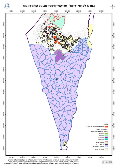
Figure 10: The CBC Project in the Negev.
5. GIS AND GEOSPATIAL DATA
Since 1991 a National GIS was created by SOI to serve the government
ministries and agencies as well as to support the community of
nation-wide geospatial consumers.
The data source of the National GIS was based on triangulated aerial
photographs, taken at 20,000' altitude, using analytical and digital
photogrammetry.
The current revision cycle is 2-3 years, except for roads and
orthophoto which are revised annually.
The National GIS of the Survey of Israel consists of a topographic
data base including ten topographic layers: orthophoto, elevations,
roads, buildings, hydrographic features etc., a cadastral database
including blocks and plans, and a database of addresses.
The National GIS infrastructure consists of the spatial data
infrastructure of the Survey of Israel and of many government offices as
well as medium and large cities and towns, utility companies and public
organizations.
Orthophoto production and data collection is carried out by the private
sector. This is the main trend, and Israeli companies provide integrated
geospatial products and services, orthophotography, mapping, GIS,
cadastre, visualization tools and more.
The usual mode of cooperation between SOI and the private sector is
that SOI defines the specifications; private companies carry out the
data collection and the staff of SOI does quality control and
integration of the data into the National GIS (see Figure 11). Then, SOI
provides data and services directly to the end users.
The implementation of imagery technologies is highly developed in
Israel since 1973. This led to development of the local industry.
Israeli manufactures supply satellite imagery all over the world.
Recently, Israeli digital aerial cameras influence the photogrammetric
market. These developments caused SOI to update the regulations in order
to certify the use of non traditional aerial cameras for mapping
applications.
Figure 11: The Status of the National GIS.
Another activity in SOI, regarding the National GIS, is to integrate
the hydrographic data, which was collected for the production of the
hydrographic charts, with the topographic GIS in order to create a
continuous GIS covering the land and the sea. The main challenge of this
activity is to overcome the different standards that are used for land
information and for hydrographic information.
6. THE GEOSPATIAL PORTAL
Around two years ago a SOI launched the National Geospatial Portal
(NGP) (Srebro H. et al., 2006 and Srebro H., 2008). This portal has been
developed in cooperation with the Inter-agency Committee for SDI. The
portal is already operating for two years. It is part of the
e-Government initiative and serves simultaneously as a geospatial portal
for the public and a governmental GIS clearing house. For the time being
it serves the public free of charge. Following a thorough analysis of
the options, the decision was made to build a geospatial data warehouse
at the first stage, in order to improve the quality control of data.
This approach was adopted because of the variety of data sources. Though
the quality of data based on the National GIS is very good, one cannot
assure the quality of uncontrolled data coming from all ministries and
agencies, so that integrated applications of the simple end web-user may
not meet the expected standards.
Following the resolution of the Inter-agency Committee with reference
to the national geospatial meta-data standard based on ISO19115, this
standard was adopted for the portal as well. Meta-data for 400 layers of
geospatial data has already been prepared and is accessible in the
system.
The system works quite fast and passed successfully loading
simulations. Potential users are exposed to the portal and are very
satisfied with it, including the education community and potential
emergency applications.
The first objective of the portal is to consolidate, to integrate and
distribute geospatial data following the e-Government policy of making
the data available to the public.
The second objective of the portal is to serve as a clearing house of
geospatial data between governmental offices and thus to save
governmental investment and to improve compatibility and integration
between governmental offices regarding geospatial and location based
applications.
The expectation is that the exposure of data will also stimulate
processes of improving the quality and precision of the data.
A steering committee of the two organizations headed by the Director
General of the Survey of Israel (who chairs the Inter-Agency committee)
defines the goals and confirms the planning. A working team of the
committee defines the requirements and controls their achievement while
working teams of SOI are responsible for their execution.
The main components of the system are: data collection, data
integration, simple web operational search mechanisms, national
geospatial meta-database, data sharing and data distribution mechanisms
and a variety of links to GIS and mapping web sites.
The architecture of the NGP is based on servers in the SOI, which
operate as a Data Warehouse supporting, via intranet, internal users of
SOI and distributing the data to an identical environment at the central
web site of the government using its services, including security of
data. The government site data is distributed to the various government
offices including web services and via Fire Wall and the internet to the
public.
The mode of interaction between SOI, the government offices and the
public is as follows (see Figure 12): SOI collects GIS data of various
government offices and public organizations using the coordination of
the Inter-Agency Committee for SDI, checks the data and integrates it
into the Geospatial Data Warehouse of the Portal. The public (the web
users) can either query the NGP directly for pure geospatial subjects,
or access via the government portal, a portal of a government office for
a complicated issue. The portal of the government office will integrate
its internal IT and GIS data extracted by the NGP using API (Application
Programming Interface) (see Figure 13).
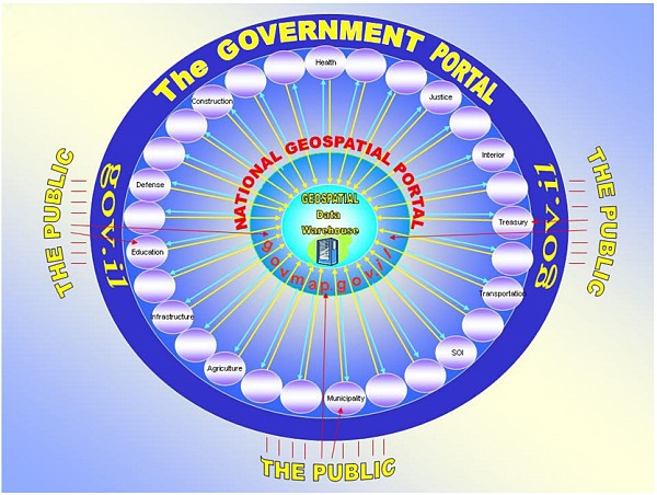
Figure 12: The Online Geospatial Configuration
Data Included in the Portal:
The core of the National Geospatial Portal is a Geospatial Data
Warehouse that includes more than 120 layers of geospatial data
collected by governmental organizations, thirty of which are from the
SOI.
The Portal represents data with great variability and richness that
enable the system to sort the layers under main topics and the user to
extract relevant metadata. The portal is integrative and the data
includes many thematic layers, such as basic mapping (roads, buildings,
addresses, orthophoto, contours, hydrology, institutes, various scales
of raster topographic layers etc.), layers of cadastre and planning
(blocks, plots, town plans, master plans, land reserves, etc.), tourist
information (national resorts, national parks, hiking trails, forests,
woods, parking areas, etc.), administrative boundaries, transportation,
infrastructure, security and national emergencies. The portal enables
simultaneous presentation of multiple layers of information, with high
cartographic fit, linked to attribute information in various formats
according to the spatial entities.
In addition, and based on the general data in the system, there are
engines that enable links to other databases, that might give specific
information in special operative applications in the future, for
internal governmental usage.
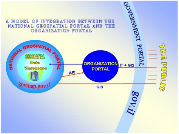
Fig. 13: A Model of Integration between the National Geospatial
Portal and a Portal of a Government
Organization.
The current activities and future environment:
The Geospatial Portal is the main platform for the online services of
the Survey of Israel to Governmental agencies, to the general public and
to the professional community including private surveyors.
Additional on line channels will be used in order to augment the
geospatial portal. The goal is to supply within two years most of the
services on line. This will include:
- The use of the Active Permanent Stations, which operate today
through the internet in a separate track.
- A direct access to the National Geodetic Data Base (NGDB) (see
Figure 14), which will open this year.
- An on-line communication with surveyors for the evaluation of
control points surveyed by private surveyors. This will operate next
year.
- A direct access to the cadastral data base.
- An on-line communication with surveyors for the evaluation of
mutation plans. This will work next year.
- A direct access to the National Archive of Maps and Aerial
Photographs. This will operate next year.
- A direct access to the cadastral GIS, to the topographic GIS, to
a cartographic data base and to the geospatial data of the Survey of
Israel and of other governmental and public organizations. This
operates today through the Geo-Spatial Portal and will expand in the
future.
Figure 14 shows the Survey of Israel on-line data and services model.
Figure 15 shows the system interface configuration, describing
schematically the relationship between the internal production
environment and the external service environment.
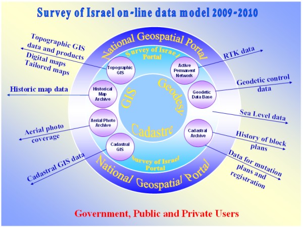
Figure 14: The Survey of Israel On-line Data and Services Model.
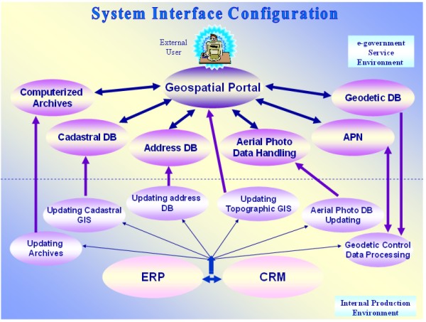
Figure 15: The Relationship between the Internal Production
Environment and the External Service Environment.
7. MAPPING
The Survey of Israel used to print a full range of maps, from small
scale of all the country to town maps and large scale topo-cadastre
maps. Following the changes in the market, where GPS navigation, private
mapping and internet maps play an important role, SOI reduces its map
printing activities. Currently the main products are: 1:250,000 and
1:400,000 basic maps, both physical and travel maps; 1:50,000
topographic series, mainly for nature hiking, augmented by selected
coverage of 1:25,000. The production line of these maps is undergoing a
major shift. During last years SOI developed a process of automation,
including generalization, of parts of the production of these maps
directly from the national GIS.
In addition, customers can get a tailored made map on demand from the
national GIS.
A special project of hydrographic mapping ended recently, covering
the Mediterranean coast of Israel by 10 maps, used mainly for safety of
navigation. These maps employ data which was collected in cooperation
with other agencies, conducting new bathymetric surveys. The current
effort is to produce a hydrographic chart of the head of the gulf of
Eilat/Aqaba.
The New Atlas of Israel – The National Atlas, published recently, is
considered a special achievement of the cooperation between SOI and the
Hebrew University of Jerusalem. This Atlas, which depends on the most
official and reliable data, and is a result of intensive research of
academic prominent figures, is an important contribution of SOI to the
public and especially for education in the field of Geography. The
advanced technologies, which were used for the analysis and production,
contributed to the final results and are highly appreciated by geography
teachers and students.
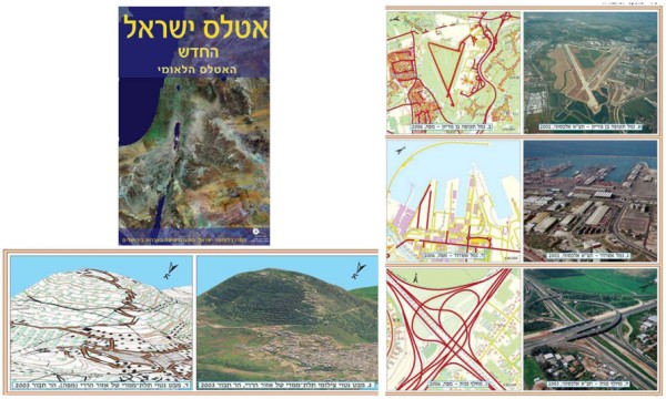
Figure 16: Examples of The New Atlas of Israel.
8. NATIONAL ARCHIVE OF MAPS AND AERIAL PHOTOGRAPHS
SOI is maintaining the National Archive of Maps and Aerial
Photographs, being considered as an extension of the Israeli National
Archives. These archives contain about 800 thousand aerial photographs
and more than 100 thousand maps. The maps were scanned and during next
year will be available on-line during the next year.
The aerial photographs include photographs of Palestine from WWI and
from WWII and annual coverage of Israel for more than 50 years. The
coverage is planned to be available on line next year. The photographs
are easily accessible, but the scanning of the entire photo archive is
yet a big challenge for the future.
9. CONCLUDING REMARKS
The Survey of Israel is undergoing a revolution in its way of
thinking and its ways of activity.
The important issue is the focus on service, the focus on interaction
with the public, with other government and public agencies and with the
private market.
In a changing world, following a trend of significant decrease of
manpower, and changing expectations of the customers, including
alternative suppliers of data and services using the internet, the
organization has to adapt itself to the changing environment and to
change itself. Otherwise, the organization will loose its relevance.
One major step that the Survey of Israel adopted is to turn all its
services to on-line and to make the data accessible to the public. These
steps come in addition to the basic requirement from the Survey to be a
leading professional organization. The Survey had always high reputation
regarding the expertise and professionalism of its staff. The expertise
of the staff should be maintained and continuously developed.
Following the current trend, the future of National Mapping Agencies
will be based on online services both to the general public and to other
government and public organizations. This refers to geodetic services
based on satellite permanent stations (combining GPS, GLONASS and
GALILEO) both for horizontal and vertical references. It refers to
coordinate based cadastral framework, databases and computerized
archives as well as supporting control of cadastral mutations based on
the permanent stations. This refers also to geospatial databases
including rectified imagery (either from aerial photographs, or
satellite images), topographic data, addresses and more.
The data integrated in the SOI GIS should be accessible through the
web, through geospatial portals, either free of charge, or selectively
accessible due to security, or payment policies.
The geospatial data should be accessible to government agencies for
integration with the IT infrastructure for integrated web services
through web portals. A special attention should be paid to the use of
geospatial information by geography learning portals for the full range
of users between kindergartens and university graduates.
These activities should be taken care of by partnership between the
government and the private market. The government should define the
vision, the goals, the specifications and supply budgets if necessary,
while the private sector should be the contractors and sometimes also
promote initiatives.
ACKNOWLEDGEMENT
The author thanks his predecessors and leading persons of the Survey
of Israel who contributed to the processes leading to its current
developed status including Dr. Ron Adler, Zion Sitruq and Aviel Ron. He
thanks senior SOI technical persons including Giora Golod, Dr. Joseph
Forrai, Dr. Gershon Steinberg, Dr. Yuri Raizman and Jochanan Gavish
including advisers as Prof. Ammatzia Peled and Dr. Gilad Even-zur, and
additional employees who contributed to the achievements described in
this article including Gilli Kirschner, Moshe Rozenbloom, Yossi Melzer,
Marina Kozakov, Dr. Yaakov Tuchin, Lyubov Kagansky, Einat Salmon,
Michael Klebanov, Ytzhak Fabrikant, Larissa Voznesensky, Vera Lavan,
Moshe Benhamu, Dr. Yaron Felus, Yaakov Bar-Lavi, Yoav Tal, Baruch
Peretsman, Shmuel Bloch and many others.
Special thanks to Dr. Gershon Steinberg, Dr. Joseph Forrai and Dr.
Yaron Felus for their constructive comments and to Rachel Saranga and
Lea Ezra.
REFERENCES
Adler R. and Papo H.B., 1984, Change of Projection Following
Readjustment, The Cartographic Journal, Vol. 22, pp. 138-140, 1984.
Forrai, J., Murkes, S., Vosnesensky, L. and Klebanov, M., 2004,
Development of a Better Cadastral Practice at the Survey of Israel, FIG
Working Week Athens, Greece, May 22-27, 2004.
Forrai, J., Gavish Y., Voznesensky L. and Bar-Maor A., 2008,
Development of an Advanced Cadastral Management System at the Survey of
Israel, submitted to FIG Working Week 2008, Stockholm, Sweden 14-19 June
2008.
Forrai, J. and Kirschner, G., 2009, Introducing Supervising Surveyors
– Five-year Experience of an Unusual Governmental Enterprise, Submitted
to FIG WW Eilat, 3-8 May 2009.
Srebro H., Bar-Lavi J. and Weiss B., 2006, A National Geographic
Portal, GSDI-9, Santiago, Chile, November 2006.
Srebro H., 2008, Geospatial Initiatives in Israel, GIS Development,
Vol. 12 Issue 1, January 2008.
Srebro H. 2008, The Future of the Survey of Israel: On-Line Services,
FIG Working Week 2008, Stockholm, Sweden 14-19 June, 2008.
Shoshani U., Benhamo M., Goshen E., Denekamp S. and Bar R., 2004,
Registration of Cadastral Spatial Rights in Israel – A Research and
Development Project, FIG Working Week Athens Greece, May 2004.
Steinberg G. and Even-Tzur G., 2005, Establishment of National Grid
Based on Permanent GPS Stations in Israel. Surveying and Land
Information Sciences, 65(1): 47-52.
Steinberg G., 2006, New Survey Regulations for Israel, XXIII
International FIG Congress, 8-13 October 2006, Munich, Germany.
Steinberg G. and Even-Tzur G., 2006, Permanent GNSS Networks and
Official Geoid Undulations Model as a Substitute for Orthometric
Control, XXIII International FIG Congress, 8-13 October 2006, Munich,
Germany.
BIOGRAPHICAL NOTES
Dr. Haim Srebro serves as the Director General of the Survey
of Israel since 2003 and is the Conference Director of FIG Working Week
2009.
He was awarded B.Sc. in Civil Engineering and M.Sc. in Geodetic
Engineering from the Technion, Haifa, and was awarded Ph.D. from
Bar-Ilan University. He has 40 years of experience of managing big
projects of photogrammetry, geodesy, cartography and digital mapping. He
is chairman of the Israeli government Inter-Agency Committee for GIS and
a co-chairman of the Israeli-Jordanian Joint Team of Experts dealing
with the international boundary.
Dr. Srebro has been for the last 35 years a leading figure in the
delimitation and demarcation of the international boundaries between
Israel and its neighboring states including Egypt, Jordan, Syria and
Lebanon. He was responsible for and signed the land and maritime
boundary delimitations between Israel and Jordan as part of the Peace
Agreement.
CONTACTS
Haim Srebro
Survey of Israel
1 Lincoln st.
Tel-Aviv
ISRAEL
Tel. + 972 3 6231901
Fax + 972 3 5610866
Email: haim@mapi.gov.il
Web site: www.mapi.gov.il
 |