Article of the Month -
December 2013
|
Climate Change and Responsible Governance: The Role of Surveyors in
Assisting Small Island Developing States
John HANNAH, New Zealand
1) This paper was presented
in a plenary session at the Pacific Region Small Island Developing
States Symposium, 18-20 September 2013 in Suva, Fiji. The paper
discuss how surveyors can contribution to the issues of climate change
and responsible governance, particularly as they affect Small Island
Developing States (SIDS). The paper reflects some of the work the FIG
Task Force on Climate Change has been undertaking since it was
established in 2010. John Hannah is chair and at the FIG Congress 2014
in Kuala Lumpur, Malaysia the task force will deliver a final report.
ABSTRACT
Small Island Developing States (SIDS) face much
higher vulnerabilities than developed nations. A substantial number of
these vulnerabilities are linked to climate change and involve decisions
over the future best use of land and other resources. The surveyor has a
diverse skill set that can be used to provide the data, the analyses,
the insights and the understanding needed to help make these decisions.
This paper then, which reflects some of the work of the FIG Task Force
on Climate Change, discusses the contribution that surveyors can make to
the issues of climate change and responsible governance, particularly as
they affect SIDS. It begins by outlining the role that the surveyor can
play in climate change and land governance studies and then discusses
the important issues being faced by SIDS. It then draws all these
threads together, making some firm suggestions as to how surveyors can
help SIDS as they grapple with future change. It concludes by noting
that while in recent decades it has perhaps been the profession’s lack
of public profile that has limited the call for such contributions, this
need not be the case in the future.
1. INTRODUCTION
The professional skills that form an essential part
of the surveyor’s tool kit, while not widely appreciated or understood,
are diverse, varied and valuable. In its most recent definition of the
functions of a surveyor, the International Federation of Surveyors (FIG)
considers that such a person has the, “academic qualifications and the
technical expertise to conduct one or more of the following activities:
-
to determine, measure and represent land,
three-dimensional objects, point-fields and trajectories;
-
to assemble and interpret land and geographically
related information,
-
to use that information for the planning and
efficient administration of the land, the sea and any structures
thereon; and,
-
to conduct research into the above practices and
to develop them” (FIG, 2004).
While these are very broad statements of capability,
they give rise to a practical, pragmatic professional person who
understands spatial measurement, who can represent and interpret spatial
information, who is very competent in the administration and governance
of rights to the land and sea, and who is capable of planning for the
development and use of land. Such a person typically has much of the
technical understanding and many of the skills necessary to exercise
responsible governance over land, being willing to innovate and reform
where necessary. The breadth of professional knowledge and experience in
these issues that surveyors have is an invaluable resource to a world
seeking long-term sustainable solutions to its many and varied land
administration problems.
In addition to finding solutions to
these land administration problems, the surveyor’s expertise in spatial
measurement and analysis allows reliable measurements to be made in
monitoring some of the direct impacts of climate change. For example, it
is the surveyor who measures sea level rise, then links these
measurements to a local reference frame. The surveyor then further links
these to a global reference framework. It is only in such a framework
that the true global impacts of climate change can be understood.
Additionally, it is the surveyor who is able to take a wide variety of
measurement data, transform it into a common reference system and then
integrate it into a Geographic Information System (GIS). The GIS then
becomes a powerful tool for assessing the likely impacts of climate
change on communities (large or small) thus supporting the development
of the mitigation policies needed to protect those communities.
This paper then, which reflects some of the recent work of the FIG Task
Force on Climate Change as well as earlier work done in 2010 (see FIG,
2010), discusses the contribution that surveyors can make to the issues
of climate change and responsible governance, particularly as they
affect Small Island Developing States (SIDS). It begins by outlining the
role that the surveyor can play in climate change and land governance
studies and then discusses the important issues being faced by SIDS.
Finally, it draws all these threads together, making firm
recommendations as to how surveyors can help SIDS as they grapple with
future change.
2. CLIMATE CHANGE – THE ROLE OF THE SURVEYOR
The evidence for present day, human induced climate
change is overwhelming. However, the full extent to which climate is
likely to change in the future (both near term and long term) remains
unclear. Climate models produce a wide range of possible outcomes
depending upon the various forcing factors used – factors that, in turn,
depend upon assumptions relating to industrial growth, greenhouse gas
emissions, deforestation, and human response (amongst other things).
Coping with the resulting environmental change (the 20th ranked issue in
UNEP, 2012) requires the assessment of a wide variety of response
options.
In the same vein, other UN documents (e.g., FAO,
2012) encourage states to have laws, policies, strategies and actions
that are designed to protect the legitimate tenure rights of those
affected by climate change. Such states are encouraged to prepare and
implement strategies and actions to help those displaced by the impacts
of climate change. Similar (but wider) provisions are suggested for
dealing with the effects of natural disasters.
The question may be asked, ”Where do surveyors fit
into this picture?” What particular knowledge does the surveyor have
that can assist the global community as it grapples with its
understanding of the quantum of change and, with it, the various
mitigation or adaptation strategies that may be required? The paragraphs
below seek to answer these questions.
2.1 Measuring and Monitoring Change
The surveyor, by virtue of his/her spatial
measurement skills, is closely involved in monitoring spatial change.
Typically, such change is determined with respect to some coordinate (or
reference) system – a system most likely established by professional
surveyors. It was surveyors, for example, who were responsible for the
definition of the current Fiji Geodetic Datum (1986) [c.f., Hannah and
Maseyk, (1989)].
As with any reference system, its long term stability
(or alternatively, an accurate knowledge of movement in that system with
respect to time), is crucial if the data provided by global monitoring
systems are to be correctly interpreted. For example, best estimates of
global mean sea level (GMSL) change from satellite altimetry indicate a
sea level rise from 1993-2013 of 3.2 ± 0.4 mm/yr compared to in-situ
tide gauge data of 2.8 ± 0.8 mm/yr (Church and White, 2011, 2013). While
this would seem to imply recent acceleration in the rate of rise of mean
sea level (MSL) from its long-term average of 1.8 ± 0.2 mm/yr, no clear
evidence of such acceleration can be detected in the long-term tide
gauge records. Could this discrepancy then, in part, be a reference
system problem?
While the above example highlights issues at the
global level, monitoring issues at the local level are just as important
to climate change studies. It is the local surveyor who is responsible
for providing the high precision measurement link between a tide gauge
and the various bench marks needed to monitor its stability. In New
Zealand, it is the surveying community (in conjunction with others) that
has been at the forefront of the long-term sea level change analyses
that have informed public policy makers on future climate change
scenarios (e.g., Hannah et al, 2010).
2.2 Data Integration and Analysis
In any climate change analysis, “what if” scenarios
form an important part of that analysis. In principle, integration and
analysis of the relevant data needs to precede mitigation and
adaptation. It is the outcome of such analyses that will inform policy
makers if the primary need is one of mitigation or adaptation. Not only
must the spatial data used be in the same reference system (see 2.1,
above), but the spatial analysis tools used for such analyses must be
capable of the necessary analyses. Such tools, which are typically part
of a GIS, are found in the surveyor’s tool kit (e.g., Mardkheh et al,
2012).
2.3 Mitigation and Adaptation
From the surveyor’s spatial perspective, climate
change mitigation measures need to be developed for three primary land
use categories.
2.3.1 Urban Areas/Human Settlements. Here the
surveyor’s professional focus will be upon urban design(so as to
reduce carbon footprint), land tenure issues (so as to address
housing and urban poverty needs), and building orientation (so as to
maximise the use of renewable energy sources). In Italy, for
example, surveyors use their professional skills to assist in
certifying the energy efficiency of both new and renovated
buildings.
2.3.2 Peri-urban Areas. These are areas of rapid
urbanization that are typically heavily influenced by rural-urban
migration. Here there is a need both for spatial planning tools and
for fresh approaches to land tenure issues. De facto urbanization by
squatting is not a long-term, nor a sustainable solution. FIG,
(2010) notes that, “access to land ---- is challenged by a lack of
clearly defined property rights which in turn causes disputes and
resultant instability”.
2.3.3 Rural Areas. These regions are largely
influenced by agriculture, forestry and farming practices. For some
populations, fishing and mineral extraction are important
activities. As urban areas expand (possibly due to climate change
migration) and arable land resources diminish, increasing pressure
will be placed upon the remaining productive land resource. The
surveyor is not only able to use his spatial tools to assess and
analyse the extent and character of climate change impacts, but also
to improve land productivity. In the developed world, precision
agriculture techniques using real-time GPS measurements have been
shown to be able to improve land productivity by more than 30%.
In addition to the above, climate change adaptation
will involve the design and construction of new infrastructure
(particularly in the coastal margins and in flood prone areas), the
re-location of land boundaries (particularly those abutting water
bodies), re-forestation, the development of carbon markets and the
construction of renewable energy sources. All of these activities
require the intimate involvement of the surveyor.
3. RESPONSIBLE GOVERNANCE – THE ROLE OF THE SURVEYOR
In 2012 the United Nations Environment Programme
issued its report on the most important emerging issues related to the
global environment (UNEP, 2012). The top ranked issue in that report
relates to aligning governance procedures to the challenges of global
sustainability. It involves the task of putting in place environmental
administrative and governance processes that are representative,
accountable, effective and transparent. This, too, is an underlying
theme in FIG (2010).
3.1 Measurement and Mapping
The land and seas form two crucial components of the
global environment. In the modern world, the first step to sustainable
governance of a resource is to understand the environmental
characteristics of that resource and its spatial dimensions. In this
regard, it is the surveyor who undertakes the spatial measurements that
determine the dimensions and the topography of both the land and the sea
floor. It is the surveyor who integrates these data into the Geographic
(or Hydrographic) Information System (GIS) that, in turn, allows these
areas to be displayed in digital form, thus providing the basic stepping
stone for their sustainable management and governance.
3.2 Administration and Governance
While the accurate definition of the global
topography is a vital component in any move towards global
sustainability, it is but a supporting part of a bigger picture. The
Voluntary Guidelines on the Responsible Governance of Tenure of Land,
Fisheries and Forests in the Context of National Food Security (FAO,
2012), point to this bigger picture when they note the three important
elements of responsible governance. Such governance:
- Recognises and respects legitimate tenure right holders and
their rights.
- Safeguards all holders of these rights against threats and
infringements.
- Promotes and facilitates the use and enjoyment of these rights.
Amongst other things, states are encouraged to
establish up-to-date tenure information on land, fisheries and forests
and to hold this information in such a manner that ownership rights are
transparent. Where appropriate, land consolidation is suggested as a
means of improving layout and use. The Voluntary Guidelines then proceed
to recommend that,
“States should provide systems (such as registration,
cadastre and licensing systems) to record individual and collective
tenure rights in order to improve security of tenure rights“- (Sec.
17.1).
At their very essence, these tasks fall squarely
within the professional domain of the surveyor. In most jurisdictions it
is the surveyor who defines land (and sea) boundaries, who understands
the rights associated with the associated land parcels and who helps
devise the administrative and governance processes used to control these
parcels. The successful land titling project in Thailand that was
initiated in 1984 has served as a model for other Asian nations as an
example of what the surveying community can achieve (Brits et al, 2002).
On a much smaller scale it was two New Zealand surveyors who, in 1957,
travelled to Tonga to begin work on designing and implementing the
official cadastral survey system – a system that continues to work well
to this day. Their task was to help fulfill the constitutional
requirement that every Tongan man should be allocated an area of arable
land for the support of his family, (Alexander and Wordsworth, 2013).
Unfortunately, in some cases, while the surveyor may wish to be a change
agent, that which can be achieved is constrained by institutional
impediments such as political systems and gender bias. Long-term
sustainable solutions depend, in part, upon addressing such issues.
3.3 Land Use Planning
The 11th ranked issue in UNEP, (2012) is the need to
boost urban sustainability and resilience. The key to such
sustainability is seen to lie in the concept of “green” cities or “eco”
cities which differ from conventional cities in that they, “have a vital
mix of land uses within their borders, produce renewable energy and
provide low-energy transportation opportunities”. It is clear that the
design of such cities will require multi-skilled teams of whom the urban
planner is but one. It is of relevance to note that in some
jurisdictions (e.g., New Zealand and NSW, Australia) such planning
functions form an important part of the surveyor’s training and tool
kit. In these jurisdictions, the design of urban and rural subdivisions,
with their associated planning constraints, are an integral part of
professional surveying practice.
4. SMALL ISLAND DEVELOPING STATES (SIDS) – WHAT ARE THE ISSUES?
SIDS were first recognized as a distinct grouping of
countries at the UN Conference on Environment and Development held in
June, 1992. They are a distinct grouping of developing countries,
typically low lying, that share similar social, economic and
environmental vulnerabilities. Their greatest challenge is one of
sustainable development at a time when, for some, their very existence
may be under threat.
Briguglio (1995), in developing a vulnerability index
for such countries, noted their small size (thus leading to limitations
in natural resources, small domestic markets, a dependence upon exports
from a narrow range of products, and poor economies of scale), their
insularity and remoteness (resulting in high transportation costs and
uncertainties in supply), their proneness to a disproportionally high
level of disruption from natural disasters, and other environmental
factors. These other environmental factors were seen to include any or
all of the following:
-
depletion of natural resources leading to their
long-term unsustainability,
-
dependence upon external finance and skills and,
-
a reliance upon the use of the coastal zone for
tourism or marine related activities.
In many regards it is a combination of small size and
this latter reliance that makes them particularly vulnerable to sea
level rise and storm related devastation – both potential consequences
of climate change. It is thus no surprise that, amongst other things,
the 2005 Mauritius Strategy for SIDS (UN, 2005) specifically mentions
the need for strategies and actions related to climate change and sea
level rise, natural and environmental disasters, and land resources.
In order to provide a first measure of vulnerability,
Brigugilo (1995) developed a normalized vulnerability index. By his
assessment, SIDS countries had a vulnerability factor of 0.635 versus an
index of 0.418 for non-island developing countries and an index of 0.328
for developed countries. Even allowing for subsequent refinements in
these indices, the message remains clear, that SIDS are far more
vulnerable to natural disasters and external shocks than larger,
non-island developed nations.
Of the 52 identified SIDS countries, 14 are in the
Pacific Region. Of these 14, three (Tuvalu, Marshall Islands, and
Micronesia), are particularly subject to the consequences of sea level
rise. Indeed, even the seemingly modest rise of 18–59 cm by 2100, based
upon IPCC (2007) has the potential for very significant consequences.
Wong (2010) identifies some of the difficulties that the majority of
SIDS face with respect to climate change. Such difficulties include:
- Limited physical space within which to adapt.
- Small populations but with a high density, again limiting
adaptation options.
- Vulnerability to storm events of increasing severity.
- Relatively small watersheds and threatened water supplies.
- Narrow (and decreasing) range of land use makes
self-sustainability increasingly problematic.
- Increasing coastal hazard risk compromises tourism (typically an
important income earner).
In total, the problems arising from climate change
that directly affect SIDS are vastly greater in overall magnitude than
those facing many of the non-island developing nations. It is in this
arena that surveyors give thought to the contribution that they can
make.
5. PULLING IT TOGETHER - WHERE CAN SURVEYORS ASSIST?
The previous paragraphs provide a foundation for
understanding the role of surveyors and the particular problems faced by
SIDS. From them it should be clear that surveyors have an important role
to play in helping SIDS, not only in their development (as has been the
case in the past), but also in their adaptation to future change and the
mitigation of the effects of such change. The following avenues for
action are suggested.
1. The provision, support and maintenance of
local, stable coordinate systems that not only support local mapping
but that will also allow change to be monitored. The South Pacific
Sea Level and Climate Monitoring Project, sponsored by the
Australian Agency for International Development, is a good example
of what can be achieved. The stations that are part of this network
are shown in Figure 1.
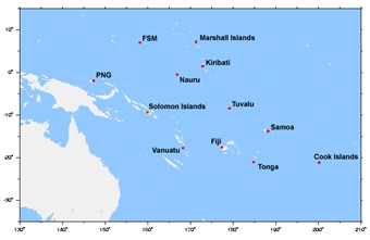
Figure 1. Stations that are part of the S. Pacific Sea Level and Climate
Monitoring Project
While some additional work needs to be undertaken
to ensure the long-term stability of the local coordinate systems
used, work is now underway on the essential task of linking each of
these sites into a global reference framework. These links need to
be maintained into the future, driven in part, by the fact that many
of these stations lie in tectonically active areas. The
determination of any tectonic uplift or subsidence is an essential
element in understanding long-term sea level rise risk. Recent
studies in New Zealand, for example, have shown that the Wellington
region is subsiding at approximately 1.7 mm/yr, thus essentially
doubling the relative rate of sea level rise for that region from
2.0 mm/yr to 3.7 mm/yr (Bell and Hannah, 2012).
2. The integration of local land and resource
related data into a Land or Geographic Information System, thus
facilitating risk, disaster management and economic analysis. The
cadastre will form a fundamental layer in any such system. Given
that SIDS by definition are small, such systems need not be
expensive. Low cost GIS packages exist, as does open source
software. Unmanned aircraft systems (UASs) can now be used for
aerial data collection, both for remote sensing imagery and mapping
imagery. Although typically used for tasks that require fast data
collection and frequent observation of a specific area, the extent
of their coverage is a simple function of flying height and lens
focal length. UASs offer excellent potential to SIDS where the cost
of mobilizing traditional aerial mapping platforms is very high.
3. The rethinking of some traditional land-tenure
practices. In the South Pacific, some 83-97% of land remains vested
in the stewardship of indigenous guardians who retain the superior
interest in and control of the land (FIG, 2010). Where freehold
title to land has been granted in the past, or where such superior
interests exist, it may be time to move to more of a leasehold
model. Freehold implies permanency, whereas leasehold implies the
opposite. Preparing for future inundation, particularly in the
coastal margins, may be better served if land-holders had a more
temporary (or time-limited) view of their holdings or land tenure
rights. Equally, the compression of more people into increasing
limited land areas suggests that traditional land tenure rights over
the “safer” areas (most likely the higher standing land), will need
to be reconsidered.
4. Where appropriate, improved transparent
systems of land governance (e.g., registration, cadastre and
licensing systems) need to be implemented to record individual and
collective tenure rights. Such transparency will not only help
eliminate corruption, should it exist, but as noted in Point 2.
above, such systems form an essential and necessary pre-requisite to
effective land administration and management.
5. Improved land planning practices. It is clear
that land in the coastal margins will require either measures to
mitigate future sea level rise or will need to be subject to a
process of managed retreat. In either event, integrated coastal zone
management will be required. Such planning practices are becoming
established in some parts of New Zealand (Bell and Hannah, 2012).
“What if” scenarios are easily modeled by GIS software. In addition,
however, remaining arable lands will need to become more productive
if island communities are to at least maintain the status quo. While
precision agriculture finds its best use over large expanses of
arable land, there will be opportunities for its use in some island
communities.
6. New (or extended) research initiatives. The
susceptibility of Pacific SIDS to seismic activity and to vertical
tectonic motion is well known. However, the spatial extent of such
motion needs to be determined. This will require long-term GPS
monitoring campaigns such as is found in New Zealand’s GEONET (see
www.geonet.org.nz). In addition, work is required on assessing
alternative land tenure options and planning practices. It would be
preferable that that such activities be undertaken by local SIDS
communities wherever possible, but this, in turn, presupposes the
availability of a pool of skilled professional people. In some cases
this will require an investment in people.
CONCLUSIONS
Surveyors have traditionally played an unheralded but
leading role in the development of small nations. Their spatial
measurement, planning, and land administration skills have combined to
support the development of essential elements of island infrastructure.
As SIDS face the significant changes that lie ahead, the surveying
profession has the skill base to provide assistance through this next
phase of their development. In recent years it has perhaps been the
profession’s lack of public profile that has limited the call for such
contributions. This need not be the case in the future. The author would
advocate strongly that great benefit could be derived by SIDS if they
had greater access to the knowledge and skills that are an integral part
of the surveyor’s professional tool-kit. This should be an integral part
of their capacity building exercises.
REFERENCES
Alexander, B., and Wordsworth, L.S (2013). 100 Fathoms Square - the
Surveying of Tonga. Available from Bruce Alexander, 111 Hackthorne Road,
Cashmere, Christchurch, 8022, NewZealand.
Bell, R.G., and Hannah, J., (2012). Sea-Level Variability and Trends:
Wellington Region. Report prepared by the National Institute of Water
and Atmospheric Research (NIWA).
Briguglio, L (1995). Small Island Developing States and Their
Economic Vulnerabilities”. World Development, Vol. 23, No. 9,
pp.1615-1632.
Brits, A-M., Grant, C., Burns, T., (2002). Comparative Study of Land
Administration Systems with Special Reference to Thailand, Indonesia and
Karnataka (India). Regional Workshops on Land Policy Issues, Asia
Program. Available at
http://www.landcoalition.org/sites/default/files/legacy/legacypdf/wbtcsind.pdf?q=pdf/wbtcsind.pdf
Church, J.A., and White, N.J., (2011). Sea-Level Rise From the Late
19th to the Early 21st Century”. Surveys in Geophysics 32:585-602,
doi:10.1007/s10712-011-9119-1
FAO, (2012). Voluntary Guidelines on the Responsible Governance of
Tenure of Land, Fisheries and Forests in the Context of National Food
Security, available from FAO, Rome.
FIG, (2004). Found at
www.fig.net/general/definition.htm and accessed
on 4 Sept. 2013.
FIG, (2010). Sydney Agenda for Action (Small Island Developing States
and the Millenium Development Goals: Building Capacity). FIG Publication
No. 53, available from
http://www.fig.net/pub/figpub/pub53/figpub53.pdf
Hannah, J., Bell, R., Paulik, R., (2010). Sea-Level Change in the
Auckland Region. Report prepared for the Auckland Regional Council.
Hannah, J., and Maseyk, J., (1989). The Definition and Adjustment of
the Fiji Geodetic
Datum – 1986. Survey Review, Vol. 30, No. 1.
IPCC, (2007). Climate Change 2007: Impacts, Adaptation and
Vulnerability. Cambridge University Press.
Mardkheh, A.J., Mostafavi, M.A., Bédard, Y., and Long, B., (2012).
Toward a Spatial Decision Support System to Improve Coastal Erosion Risk
Assessment: Modeling and Representation of Risk Zones. Presented at the
FIG Working Week, Rome, May, 2012. Available at
http://www.fig.net/pub/fig2012/papers/ts04k/TS04K_jadidimardkheh_mostafavi_et_al_5958.pdf
UN, (2005). Found at http://www.sidsnet.org.
UNEP, (2012). 21 Issues for the 21st Century: Result of the UNEP
Foresight Process on Emerging Environmental Issues. United Nations
Environment Programme, Nairobi, Kenya.
White, N., (2013). Historical Sea-Level Changes Over the Last Two
Decades. CSIRO sea-level rise web site:
http://www.cmar.csiro.au/sealevel/sl_hist_last_15.html
Wong, P.P. (2010). Small Island Developing States. WIREs Climate
Change 2011 2 1-6 DOI:10.1002/wcc.84. John Wiley and Sons Ltd.
BIOGRAPHICAL NOTES
John Hannah completed his BSc (Surveying) in 1970, a Post Graduate
Diploma of Science in 1971, and became a Registered Surveyor in New
Zealand in 1974. He subsequently completed an MSc and PhD at The Ohio
State University. From 1982 -1988 he was employed by the Dept. of Lands
& Survey, New Zealand as a Geodetic Scientist and then as Chief
Geodesist/Chief Research Officer. After an appointment to the Chair in
Mapping, Charting and Geodesy at the US Naval Postgraduate School,
California in 1989-1990, he returned to New Zealand as Director of
Geodesy and then Director of Photogrammetry for the Dept. of Survey and
Land Information. In 1993 he joined the School of Surveying at the
University of Otago as Professor and Head of Department. He became the
School’s Dean in 2001, relinquishing this role at the end of 2004. From
2005-2007 he was President of the NZ Institute of Surveyors. He retired
from the University of Otago in 2012 and is currently the Managing
Director of his own consultancy, Vision NZ Ltd. He is Chair of the FIG
Task Force on Climate Change and is on the Council of Standards New
Zealand.
CONTACTS
Emeritus Professor John Hannah
University of Otago Vision NZ Ltd.
School of Surveying
22 Woodstock Place
PO Box 56 Stoke
Dunedin 6054 Nelson 7011
NEW ZEALAND
Tel. + 64 3 479 7585; + 64 3 547 3061
Fax + 64 3 479 7586
Email: john.hannah@otago.ac.nz
and jandlhannah@gmail.com
Web site: www.otago.ac.nz
 |