Article of the Month - February 2025
|
The article of the month in February are a short version of article
written by Fritz Staudacher (who is also well known for his
work on Jost Buergi), a comparative historical article about the
Swiss engineer Heinrich Wild and Albert Einstein.The article
describing until now unknown relations between Nobel Price winner
Albert Einstein and Heinrich Wild, the most important designer of
geodetic and photogrammetric instruments of the last century. While
Henry Wild revolutionized the surveying and mapping of our planet
Earth with completely new instrument designs, Albert Einstein's
unconventional findings and theories influenced the world view of
physics as it had existed until then. Today, the knowledge and
technologies both discovered at the time are combined in modern
surveying stations.
Albert Einstein and Heinrich Wild: The
Beginning of two Great Global Careers
Fritz Staudacher
This article in .pdf-format
(13 pages short version)
This article in .pdf-format
(65 pages)
At the beginning of the last century, two federal officials in Bern
began their world careers: Heinrich Wild (1877-1951) and Albert Einstein
(1879-1955). Today, the knowledge and technologies they discovered at
the time are combined in modern surveying stations. While the former
revolutionized the surveying and mapping of our planet Earth with
completely new
instrument designs for geodesy and photogrammmetry, the latter's
unconventional findings and theories influenced the world view of
physics as it had existed until then.
F. Staudacher
Heinrich Wild is still considered today to be ‘the most important
designer of geodetic instruments who ever lived’; the discoverer of the
dual nature of light (‘photoelectric effect’) and Nobel Prize winner in
physics Albert Einstein, due to his theories of relativity, is
considered by Time magazine to be the person with ‘one of the most
significant, if not the most significant, expressions of human thought’.
Heinrich Wild and Albert Einstein came from Winterthur to Bern at the
age of 23 to take up their first civil servant positions. There they had
studied (Heinrich Wild) or taught (Albert Einstein) at the technical
college. It was in Bern that Heinrich Wild first developed his concept
of intelligently miniaturizing and combining device functions using fine
mechanical and precision optical components in such a way that
completely new instruments could be brought to market.
Einstein's theories are much more elementary and can only be used in
surveying after they have been implemented in application technologies
by physicists, electronics engineers and industrial engineers, and
integrated into instruments for a wide range of surveying tasks in a
user-friendly way by design companies with personalities like Heinrich
Wild. With Einstein's findings, this has only been the case since the
second half of the last century with the laser, the digital sensor and
the relativistic corrections in space travel, as well as the GPS
satellite networks. Since then, devices based on the basic concepts of
Wild's designs have been enriched with the new technologies derived
primarily from Einstein's theories – right up to the 3-D point cloud
scanner and the ‘self-learning robotic total station’.
Heinrich Wild: topographer, inventor and company founder
The global success story of the elder of the two Swiss began in Bern
in April 1900, when Heinrich Wild was accepted by the director of the
Topographical Bureau (known as the Topographical Survey from 1902; now
also known as swisstopo), Jean-Jacques Lochmann, into the coveted
position of a second-class topographer. Under the instruction of Dr
Robert Hilfiker, Heinrich Wild's first tasks as a topographer were to
carry out the Neuchâtel-Biel precision levelling, to survey the St.
Maurice fortress area with Max Rosenmund, to survey glaciers on the
Rhône glacier with Leonz Held, and to independently carry out
triangulations and forest surveys in the canton of Valais.
One of Heinrich Wild's most important special tasks is taking
responsibility for all the instruments available at the office. This
also means maintaining contact with their manufacturers or with
instrument-making companies that are emerging, which is why the Zeiss
precision optics company in Jena registers Heinrich Wild as a freelance
scientific employee from April 1900. Although Zeiss does not yet have
any geodetic instruments in its product range, it does have
photogrammetric devices and military rangefinders. On 1 February 1904,
Heinrich Wild applies for a correctable double-image distance meter as
his first patent and sells it to Zeiss in the same year. He adds a
further invention, a protected adjustment device for the construction of
telemeter in 1907, which will bring him a royalty of 6% of the sales of
these devices.
On 1 September 1902, Heinrich Wild had a particularly negative
experience with a repeating theodolite of the time during a
triangulation on the summit of the 3257-metre-high Dents-du-Midi in the
Lower Valais, an experience that haunted him. Through years of
observation and reflection, trial and error, and consistent error
analysis, he improved the triangulation method and identified and
eliminated sources of error in levelling.
The year 1905 proved to be important for Heinrich Wild in four ways:
he was now able to identify all the improvements that needed to be made
to this angle measuring device and drew up a specification for an ideal
theodolite: It had to be ready to measure faster and easier to read, as
well as smaller, lighter and more reliable than the then-standard
30-kilogram theodolite equipment. Secondly, in the same year, Director
Leonz Held promoted him to the rank of Topographer I. Class and,
thirdly, the military promoted him to the rank of lieutenant. Fourthly,
he was appointed to the Swiss Military Commission for Optical
Rangefinders. He received his first patent for an essential design
element of his theodolite in 1907 for his invention of a diametrical
circle reading using a microscope. But he only trusted Zeiss in Jena to
build such a device that could be used in the field – and he had tested
it in vain at Kern in Aarau and at Wandschaff in Berlin. As early as the
beginning of March 1906, Heinrich Wild discusses with the Zeiss
management a collaboration including his joining Zeiss to set up a
geodetic department. ETH professor Fritz Kobold: ‘When Heinrich Wild
leaves the Topographical Survey of Switzerland in Bern at the end of
1907, the Swiss national survey will lose the man to whom it primarily
owes its revival at the beginning of the century.’
Already the ‘most important designer’ in 1908
From March 1908, Heinrich Wild was able to establish the Zeiss
Geodetic Instruments Department in Jena, Thuringia. His completely new
levelling instrument with a rolling telescope surprised experts and
competitors alike. Theodolites were added, making Zeiss the market
leader in the field of geodetic instruments by 1921. Geodesy professor
Fritz Deumlich:
‘Since 1908, Heinrich Wild's inventions have become more and more
accepted. This has led to a standardization of the instruments’
principles.’ In this way, Heinrich Wild also earned a reputation as the
most important international designer of surveying instruments. In 1921,
Heinrich Wild founded his own company with Dr Robert Helbling-Spoerry
and JacobSchmidheiny in Heerbrugg in the St. Gallen valley of the Alpine
Rhine. This Heerbrugg-based company is still an international market
leader today under the name Leica Geosystems, and has been continuously
expanding this positionfurther since 2005, thanks in part to its
affiliation with the Swedish high-tech group Hexagon. However, after the
introduction of numerous geodetic and photogrammetric devices, company
founder Heinrich Wild left the company with a heavy heart in 1932 due to
differences in opinion. Without the responsibility for a company, but
only focused on optimal designs, he once again succeeded in creating
spectacular theodolites with short, fast telescopes and double circles
for Kern + Co., Aarau, between 1935 and 1951, which represented a
further advance in surveying. In addition, there is an optical
telemeter, a high-performance rifle scope for the Swiss Army and a
photogrammetric evaluation device.
Heinrich Wild's hidden youth
While Heinrich Wild's life is well known from the time he joined the
Topographical Survey, little is documented about what shaped him.
After years of research, we now know for sure (!) or with a high degree
of probability where Johann Heinrich Wild, a citizen of Mitlödi/GL, who
was orphaned at the age of three, was born (in Bilten!); how teacher
Grünenfelder allowed him to skip two grades at once after only six years
of schooling and let him leave school early (due to his mathematical
abilities and exceptional intellectual grasp!); and how much the small
and adolescent Heinrich missed the security of a family life (because he
was not even three years old when his father Jost Heinrich Wild was
buried in 1880, and also because his mother Elisabeth Wild-Weber worked
in Zurich and visited less and less often); how Heinrich Wild, who was
brought up extremely strictly by his maternal grandmother Regula
Leuzinger-Tschudi, was already on the payroll of the Linthwerk at the
age of twelve (because he had to earn money to make a living and his
uncle on his mother's side, Heinrich Leuzinger, a surveying engineer
trained at the Polytechnic, who was later a Linth engineer, took him
with him to the construction sites and surveying projects of the
Linthwerk and assigned him increasingly demanding work!); how, as a
fifteen-year-old, he learned far more than was envisaged in the
curriculum during his three-year apprenticeship under the Linth engineer
Gottlieb Heinrich Legler (because in Gottlieb Heinrich Legler he had an
internationally renowned hydraulic engineer as a teacher!); why he did
not pursue a diploma at the Winterthur Technical College (because he
already knew more and had more practical experience than many a lecturer
and he promised more than two semesters of attending a school for
surveyors!); why he was already earning well before being accepted into
the school for surveyors (because he had already set up his own business
after purchasing his own surveying equipment); and why he had made a
name for himself as a highly qualified surveyor and cartographer by the
age of nineteen (!) in 1896 (because in that year the perimeter plans
created by engineer Heinrich Leuzinger and Heinrich Wild between 1889
and 1896 were published, for which Heinrich Wild had spent seven years
draining swampland, surveying and evaluating plots of land and, together
with Heinrich Leuzinger, had drawn 46 perfect 70 cm × 70 cm plans at a
scale of 1:2000 (!).
Einstein: ‘I was sitting in a chair in the Bern Patent Office...’
Two years after Wild, Albert Einstein, who had graduated from the
Swiss Federal Polytechnic School in Zurich as a maths teacher, took a
job as a third-class technical expert at the Federal Office for
Intellectual Property in Bern after teaching in Schaffhausen and
Winterthur. As his biographer Jürgen Neffe describes, ‘At work, Albert
Einstein also pursued “private” projects of a fundamental nature. In a
hitherto unknown explosion of ideas, the ingenious Albert Einstein
presented a fivestage cascade of work in 1905, which is still being
continued in 1907. Einstein discovers and describes atomic forces in the
Petri dish, the dual nature of light and its light quanta, and the
relationships between energy, mass, speed of light, time and space in
the special theory of relativity. Einstein described the decoding of his
equivalence principle, which he discovered in 1907 and which was the
first major step towards the general theory of relativity that was only
completed almost a decade later, and which he described as the ‘happiest
thought of his life’. ‘I was sitting in a chair in the Bern Patent
Office. Suddenly the idea dawned on me: ‘In free fall, a person should
not feel his own weight at all’.’
Einstein's relationship with surveying goes far beyond the
theoretical tasks of a university physicist. As an instrument designer,
the pacifist Albert Einstein supported the development of a gyrocompass
device that was particularly suitable for submarines. This was patented
in the name of the main inventor Hermann Anschütz-Kaempfe and
manufactured in Kiel in such large numbers that it provided Einstein
with a substantial income. Furter Einstein was so fascinated by the
development that he not only interrupted his work on the general theory
of relativity in 1915, but also used the functional principle of the
gyroscope as a model for his atomic description of permanent magnetism.
Parallel developments at universities in Zurich, Bern and Germany
In many cases, the topographer Heinrich Wild was setting a signal at
the new location before the physicist Albert Einstein. The parallel
changes of location and profession, which were in no way coordinated by
the two people, are reminiscent of ‘entangled’ energy quanta. According
to modern quantum mechanics, the random behaviour of the smallest
particles was suspect to Einstein. But outside of the quantum,
Einstein's postulated ‘spooky action at a distance’ does exist: if you
know where Heinrich Wild currently lives and when he changes jobs, then
it is highly likely that you can also deduce the whereabouts, and a job
change of his ‘entangled’ companion Albert Einstein over a quarter of a
century. Like Heinrich Wild, his contemporary Albert Einstein, who was
two years younger, left school early due to his excellent knowledge of
mathematics and, like Wild, enrolled at a Zurich Technical University to
study in 1895/96; like Wild, Einstein worked as a federal official in
Bernese offices more than a century ago and it was here that he
developed groundbreaking new ideas in 1905; like Wild, Einstein married
at the age of 23, lived with his family at the same time as Wild in the
Thunstrasse in Bern and left the Swiss capital eight years later,
exactly like the topographer Wild, when he was exactly thirty years old;
Albert Einstein followed a professional call to Germany like Heinrich
Wild before the outbreak of the First World War and also lived there
during the famine and the collapse of the German Empire; like Heinrich
Wild, Albert Einstein is also the father of a son of the same name, both
of whom completed engineering studies. And when the professorial council
of the Swiss Federal Institute of Technology Zurich awarded Heinrich
Wild an honorary doctorate in technical sciences in 1930 ‘for his
outstanding achievements in the field of geodetic and optical instrument
design’, Albert Einstein was also awarded an honorary doctorate by ETH
Zurich in the same year ‘for his outstanding achievements in the field
of theoretical physics’.
Conclusion
It is quite remarkable what developed in parallel in the early years
of the last century, and particularly in 1905, through the activities of
two luminaries in their fields in Bern, and what presents itself today
as a useful unity: The creations of Heinrich Wild with the further
developments of Einstein's findings improved our knowledge and
orientation on Earth, but also on the Moon and in space. The largest
peaks of the continents also bear the measure of the instruments
developed from their theories and constructions, as do the most
significant structures, energy generation and environmental protection
projects, as well as numerous national maps around the globe.
Notes:
The longer and more comprehensive article with references ‘Heinrich
Wild and Albert Einstein: The Beginning of Two Global Careers’ is
available at www.geomatik.ch. or
https://people.math.harvard.edu/~knill/history/wild/index.html
Picture credits:
Albert Einstein Archives, Schweizer Nationalbibliothek Bern: Fig. 5;
Author's Archives: Fig. 4; Deutsches Museum: Fig. 10; ETH Image Archive
library.ethz.ch: Fig. 1 (Einstein); Hans Heinrich Wild: Fig. 1 (Wild);
Leica Geosystems: Fig. 2, 6, 8, 9, 11, 12, 13; Lintharchiv: Fig. 7; St.
Galler Tagblatt: Fig. 3.
Fritz Staudacher
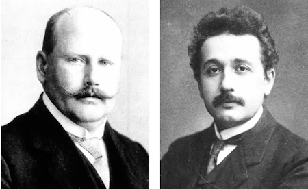
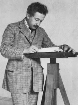
Fig. 1: The start of a global career: Heinrich Wild (1877–1951)
and Albert Einstein (1879–1955).
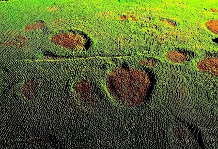
Fig. 2: Dinosaur tracks: 3D laser point clouds: the latest
Einstein technology in laser scanning, based on Einstein's work from
1916/17 ‘On the Quantum Theory of Radiation’. The 3D laser point cloud,
measured to the nearest millimetre using a Leica LaserScan in 2003,
shows dinosaur tracks in Courtedoux/JU
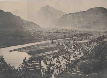
Fig. 3: Improved: Weesen on Lake Walen in 1889, when 12-year-old
Heinrich Wild began his work on the irrigation of the Linth channel.
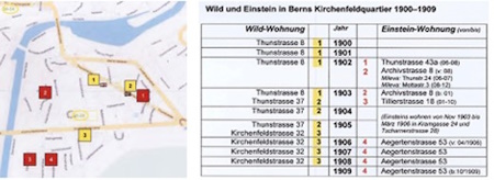
Fig. 4: Close quarters: Wild and Einstein's places of residence
between 1900 and 1909 in the Kirchenfeld district of Bern.
 |
 |
| Fig. 5: At the patent
office: Albert Einstein at the Swiss Federal Institute of
Intellectual Property around 1904. |
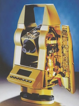
Fig. 6: United: insight into the electronic tachymeter
(total station) from 1998 from Heerbrugg with Wild construction
design for angle measurement and integrated laser distance
meter, based on Einstein's theory (Leica TC500). |
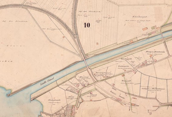
Fig. 7: Linthwerk plan: section of the Weesen area. Measured,
drawn and hand-coloured by the 18-year-old Heinrich Wild. 46 individual
plans (1:2000), 70 cm × 70 cm. (zVg Lintharchiv, signature LIAR F VIII.
19 [10]).
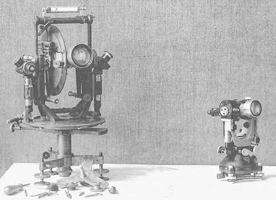
Fig. 8: Theodolite before Wild – and since Wild: Left: typical
repeating theodolite around 1900 with a 30 kg transport weight. Right:
revolutionary Wild T2 theodolite from 1923. Weight just 3 kg, with
numerous other advantages for the surveyor. This theodolite design by
Heinrich Wild has also become established worldwide for integrated
distance measurement in total stations.
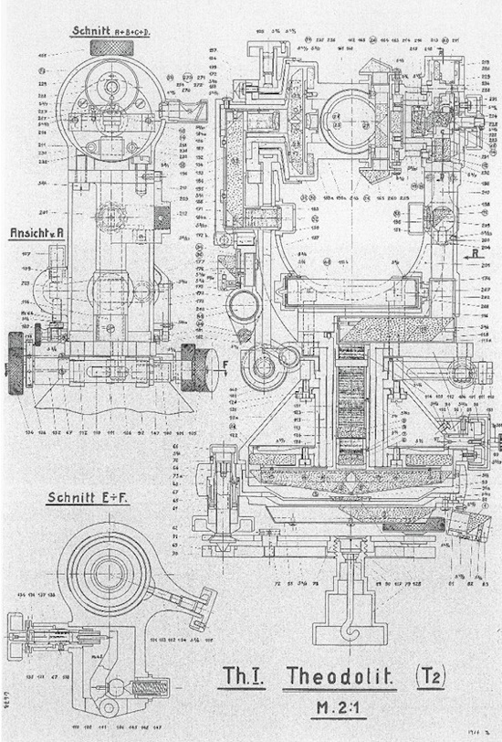
Fig. 9: Wonder: Heinrich Wild's design assembly drawing of the
revolutionary fine-mechanical optical miracle of its first Heerbrugg
theodolite Th.I,. later called and T2 from 1921/23.
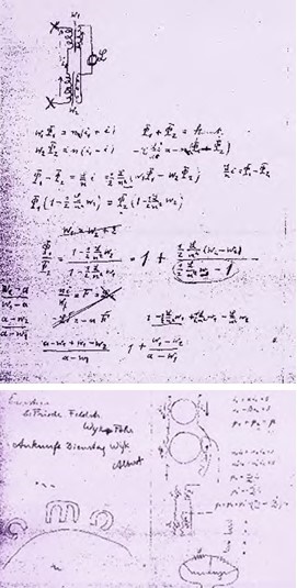
Fig. 10: Magnetic forces: pages from Einstein's calculations of
the magnetic forces of the ball-bearing gyrocompass.
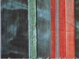
Fig. 11: Photoelectric effect: digital images such as this
infrared false-colour aerial photograph taken with the Leica ADS40
digital sensor are theoretically based on Albert Einstein's
photoelectric effect discovered in the ‘miracle year’ of 1905.
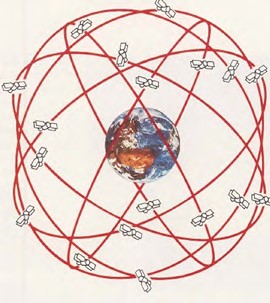
Fig. 12: Correct globally:
Correction factors from Einstein's Special and General Theory of
Relativity are used to ensure that global navigation systems (such as
GPS, Galileo and Glonass) function correctly.

Fig. 13: Multifunctional: the MS60 Multistation from Leica
Geosystems Heerbrugg combines Heinrich Wild's theodolite setup with a
laser developed from Einstein's theory in two ways: firstly, for
distance measurement like a total station and, secondly, with a
LaserScan function for capturing, measuring, evaluating and documenting
millimetre-accurate 3D laser point clouds.


