Ensuring the Rapid Response to Change, Ensuring the Surveyor of Tomorrow
Chryssy Potsiou, FIG President, Greece
|

Chryssy Potsiou, FIG President
|
1)
In this paper FIG President Chryssy Potsiou unveils her ideas for the
FIG action plan, which includes a close cooperation among FIG in order
to better prepare tomorrow’s surveyors today to enable them performing
in a sustainable way and within the framework of the FIG vision. She
also presents a summary of literature research and brainstorming input
accumulated mainly from the FIG kick-off seminar and the FIG side event
during the World Bank Conference on Land and Poverty.
SUMMARY
This paper presents a summary of literature research and the
brainstorming input accumulated mainly from the FIG kick-off seminar and
the FIG side event during the World Bank Conference on Land and Poverty,
both organized in the first quarter of 2015. Based on the FIG overall
theme “Ensuring the Rapid Response to Change, Ensuring the Surveyor of
Tomorrow” the paper aims to provide inspiration to surveyors to address
the global challenges and to structure the way ahead.
A brief overview of the global trends in the changing economies and
markets, the changing societal needs and the changing technology
together with an emphasis of the importance of timing in the surveyors’
response to change is given.
Proposals for FIG action plan, and for a close cooperation among FIG,
the regional associations and the national associations in order to
better prepare tomorrow’s surveyors today to enable them performing in a
sustainable way and within the framework of FIG vision are included.
The contribution of all international and local experts to both FIG
brainstorming events is highly appreciated and acknowledged.
1. INTRODUCTION
The International Federation of Surveyors (FIG) supports
international collaboration among its members (member associations,
affiliates, corporate and academic members) for the progress of
surveying in all its fields and applications. Through dedicated
leadership and the long and systematic work of its members, FIG has
established a close cooperation with the United Nation relevant bodies,
the World Bank and its sister associations and has been globally
recognized as the leading international non-governmental organization on
“geospatial information” and the management of “land”, the “sea” and the
“built” environment. It is within the surveyors’ task to determine the
size and shape of the earth, to map its surface and to manage it in a
sustainable way.
For the 2015-2018 time period the overall theme is: “Ensuring the
Rapid Response to Change, Ensuring the Surveyor of Tomorrow”.
Through the years almost every incoming administration of FIG has
acknowledged “change” as a reality of our world; in 1938 we
talked about “the role of the surveyor in the social order of today”,
in the 60s we were concerned about “modern technology”, in the
70s about the “Space Age”, in the 90s about the “information
society” and “globalization” and in the more recent years we
are talking about “shaping the change”, “facing the challenges”
and “engaging the challenges” and now we realize that we simply
cannot shape the change but we need to respond intelligently and
moreover we need to prepare the surveyor of tomorrow, as change
happens too rapidly (Foster, 2015). The past, all the years of valuable
and successful contributions of the surveying profession to the
sustainable development of the world since the ancient times, is a
mirror of the road ahead; however, the current global challenges seem to
be pressing and time is no longer on our side, therefore we need
sustainable, reliable, low-cost and fast solutions (Teo, 2015). Change
is inevitable; as professionals we cannot manage change, we can only
manage the way we respond to change (Retsinas, 2015). What we
traditionally do, as professionals, is to seek the relevance of our
profession and to improve our efficiency to respond to change.
Since the steel tape, the logarithms, the theodolite, the
introduction of triangulation and the least squares adjustment theory,
the cadastral maps, the revolution of photogrammetry, the electronic
distance measurement, the use of telurometer up to the satellite images
and the GNSS revolution, the GIS and the management of spatial
information, the UAVs and the mobile devices, and our leading role in
modern cadastres and marine information systems, our increased
involvement in land governance, especially in land administration, the
management of land and the sea, land and property valuation and quantity
surveying, FIG and “the surveying profession” has continuously
changed aiming to better serve a spatially enabled society. Now the
changes we face are more than technological; they are global and they
are happening quickly.
The difference today lies in the fact that “timing” is
introduced as the crucial factor in our theme. We are living in an era
of constant and rapid change:
- changing economy and changing markets that challenge us to adapt
to international processes, rules and standards;
- changing nature and changing societal needs that challenge us to
adapt our governance policies and tools especially in land
administration and spatial information management;
- changing technology that challenges us to maintain our
proficiency (Potsiou, 2014).
Today we have reached the stage where there is an increased UN and WB
recognition of how reliable geospatial information helps governments and
citizens to underpin decision making; Location intelligence is
underpinning our daily lives; being “geospatial” is a global
“transformation” (Lawrence, 2015). Google and Microsoft have served as
catalysts for making geomatics techniques familiar to a wide audience.
Geospatial information is recognized as the tool to address issues
like the so called “mega-topics”:
- population growth and the need for food and water security and
poverty eradication;
- the rapid urbanization of the world’s cities and the need to
respond rapidly and intelligently in terms of housing, mobility and
transport, city and building modeling, energy saving, health care,
water and waste management, and governance in general;
- the tendency of development to cluster within the coastal zones
of the oceans, the seas and the major river deltas and the need for
rapid response to natural disasters and to manage the impact of
climate change;
- the interconnectivity in all areas of our economies, cultures,
governmental operations and private lives and the need for
harmonization, compatibility and security of procedures.
This paper is an attempt to mainly summarize the brainstorming input
from the FIG kick-off seminar in January 2015 and the FIG side event in
the World Bank Conference 2015, and to give inspiration to surveyors to
structure the way ahead.
2. CHANGING ECONOMY, CHANGING MARKETS AND CHANGING SOCIETAL NEEDS
2.1 Security of tenure
Because of the economic changes in the late 1980s to early 1990s
there has been a major reform in the administration and management of
the land. Effective and efficient land and property markets are broadly
considered to be a crucial component of a successful market economy. The
empowerment of private property rights is the most fundamental
element of a market economy, and therefore implementation of these
rights is the key indicator of the transition process in the countries
changing from centrally planned economies to market economies. The
registration of property rights has, among other things, two main
objectives: to provide secure ownership to land and real property, and
to support the operations of the property market (Dale, 2005).
The World Bank has been financing land tenure projects for more than
half a century. Over these five decades, the Bank has allocated more
than US$3.1 billion to 92 standalone land tenure projects in 53
countries; the Bank has also financed at least 242 projects with
significant land tenure components. Of these 334 operations, 47 are
still active. These projects were mostly implemented in Latin America
and Caribbean (LAC), East Asia and Pacific (EAP) and Europe and Central
Asia (ECA), but also in Africa, South Asia (SA) and, to a lesser extent,
Middle East and North Africa (MENA). During the 1990s, due to the
increased recognition of importance of secure tenure rights for land
markets, the Bank started implementing standalone land administration
projects in ECA, Latin America and EAP that in total refer to an over
US$ 2.2 billion commitment.
At present, the Bank has committed more than US$800 million in
standalone land tenure operations and more than US$1 billion in
operations with land tenure components/activities (Bourguignon et al.,
2015) as land tenure issues are again vital for issues such as
governance transparency, recovery from financial crisis, as well as
investment in agriculture for food security and bio fuel improvement to
address climate change. Currently there are 17 standalone land
administration projects all around the world, while there is planning
for more, and 30 more development projects that also include a land
component which require adjudication and recording of private property
rights. The World Bank is also doing specific development research in 20
more countries and provides advisory services to others (Adlington,
2011; 2015). Figure 1 shows the total land tenure projects (top) and the
standalone land administration projects during the 1990s-2000s period
(bottom), financed by the World Bank.
According to World Bank data, in the ECA region the reform related to
land and properties’ denationalization and privatization has been the
greatest in history. It included 30 countries, US$1.1 billion in loans
and grants and has affected a population of about 900 million and a land
area of approximately 27.4 km2. For about 300 million properties
documentation was checked or new documents were produced, properties
were surveyed and ownership rights were registered mostly in automated
registration and cadastre systems. Much of this land was given “free
of charge” or at “low cost”, a policy which promoted the
economic transformation of the region. The establishment of property
registration systems in this region has allowed the introduction of
these assets into the national economies and increased transactions and
mortgages considerably. The pace of this economic change is accelerating
and this will continue in future. This region also had the largest share
in economies reforming business regulation in 2011/12 (Figure 2)
according to the World Bank Doing Business 2013 report, as many
countries now aim to narrow the gap in regulatory efficiency with the
established EU members and others are engaged in EU accession
negotiations (World Bank, 2013). This shows that many countries have
already made remarkable economic progress; these encouraging results
provide optimism for surveyors as well as citizens of other developing
regions that still suffer from inadequate security of tenure, incomplete
property registration and increased poverty rates. Surveyors have the
skills and the expertise in issues like the adjudication of right
holders and registration and recording procedures; property valuation;
land use planning and permitting, etc., in order to facilitate this
change. But they also have the vision and the determination to actually
make this change happen.
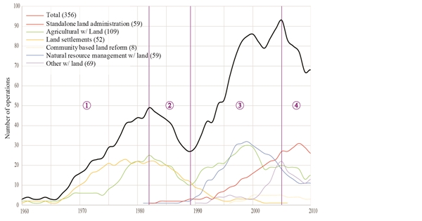
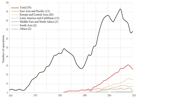
Figure 1. The World Bank land tenure projects since 1960 (top)
standalone land administration projects (1990s-2000s) (bottom) (source:
Bourguignon et al., 2015)
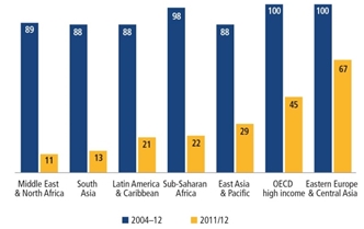
Figure 2. Eastern Europe and Central Asia had the
largest share of economies reforming business regulation in 2011/12
(source: World Bank, 2013)
FAO, the global UN food and agriculture organization, recognizing the
need gave strategic priority to the security of tenure for the
necessary reforms in order to manage all the above mentioned mega-topics
such as the population growth and especially the need for food
security, but also urbanization, environmental change and climate
change, and so on. In recent years FAO has been dedicated to the
compilation of global Voluntary Guidelines on the responsible Governance
of Tenure (VGGT) (Figure 3). Following the compilation of the guidelines
and its endorsement by Committee on World Food Security (CFS) in May
2012, there has been global enthusiasm and support by the G8, G20,
Rio+20, the Francophone Parliamentary Assembly, the UN General
Assemblies and the Berlin Agriculture Ministers’ Summits, as well as
significant private sector recognition, to proceed quickly with its
implementation by all countries. This is an intense and challenging
activity dealing with extremely sensitive and political issues such as
security of tenure and addressing corruption and land
grabbing all over the world (FAO, 2012).
Figure 3. The Voluntary Guidelines on the Responsible Governance of
Tenure (left) and the FAO global implementation program (right) (source:
Munro-Faure, 2015)
The VGGT implementation phase began in 2012 in two pillars, first by
focusing on raising global awareness through 10 regional conferences,
and secondly by organizing national focused workshops; the second phase
was initiated in 2013. National workshops are organized in two rounds,
aiming to create a national platform for (a) investigating the national
policy relevance to the VGGT, and (b) providing concrete proposals for change and harmonization. The national platform requires
the establishment of a group of stakeholders such as government
agencies, civil society, private sector and academia. FAO started the
implementation process by giving priority to 13 African countries (in
cooperation with AU, the UNECA, the AfDB, the EU, etc), 5 Asian
countries including China, and Latin American countries. In parallel,
European countries also proceed with further VGGT implementation and
continuous monitoring. In this initiative FAO cooperates closely with
its partners such as UNECA, the Global Donor Working Group on Land,
FIAN, CSM, IFAD, the World Bank, the International Union of Notaries
UINL, and FIG. FIG has strongly supported all phases beginning with
consultation and compilation, and proceeding with the endorsement and
implementation of VGGT, through the organization of workshops and the
provision of technical support and capacity development materials.
Within the goals of the Post-2015 Global sustainable development
agenda is the objective that by 2030, countries should ensure that all
men and women, in particular the poor and the vulnerable, have equal
rights to economic resources, as well as access to basic
services, ownership and control over land and other forms of property,
inheritance, natural resources, appropriate new technology and financial
services, including microfinance. Countries should also double the
agricultural productivity and incomes of small-scale food producers, in
particular women, indigenous peoples, family farmers, pastoralists and
fishers, including through secure and equal access to land. They
should also undertake reforms in terms of improving access to
ownership and control over land and other forms of property, financial
services, inheritance and natural resources (UN Open Working Group,
2014).
Therefore the question of monitoring the implementation of the VGGT
in its global context is the most challenging task. FAO has developed
formal monitoring performance procedures within its strategic framework
and innovative tools such as the Land Governance Assessment Frameworks
(LGAF) that is performing detailed testing of the progress of
implementation of the VGGT by the countries (Munro-Faure, 2015).
Currently there are about 43 LGAF monitoring studies in process; of them
24 are completed, 13 are ongoing, and 6 are prospective (Bourguignon et
al., 2015).
2.2 Property markets and the role of private sector
Economic changes are followed by rapid urbanization. Urbanization can
be viewed as an indicator of development (Potsiou et al., 2010).
Concentration of the most dynamic economic activities in urban areas
often produces economies of scale and leads to social and economic
benefits; urbanization is a major change that takes place
globally. It is also a matter of human rights that people are free to
choose where they will live and work. People move to the cities in seek
of job opportunities and of better futures. For the first time in human
history more than half the global population live in urban areas; it is
expected that this will increase into 70% by 2050; already China is 51%
urbanized. By example Shanghai’s population has almost doubled (Figure
4) in a decade from less than 13 million residents in 2000 to about 23
million today and is expected to reach 50 million by 2050. In the cities
of the developing world urban population grows at a rate of 5 million
new comers every month.

Figure 4. Shanghai in 1990 (left) and in 2010 (right) (source: Ong,
2012)
At the same time there is a growing global housing gap; it is roughly
estimated that about 863 million people live in urban slums and informal
settlements (UN-HABITAT, 2012). There is huge urban sprawl toward
agricultural lands thus increasing the risk of food scarcity. Many poor
people live in unplanned areas with flooding risk, drought and other
disaster risks (Davis, 2006), in the periphery of many mega cities in
seek of low-paid job opportunities thus supporting the economy and
competitiveness of those cities in the developing world. Management of
such viable urban areas requires not only technical skill but also
expertise in social, economic and environmental aspects. Land tools that
are applicable in the developed world are not efficient in providing
pragmatic solutions in these areas, as in most cases are time and cost
consuming in general. Surveyors should go beyond their borders;
communicate and cooperate with experts outside the surveying community
in order to achieve best results.
However, lack of affordable housing is a global issue today. Experts
and governments of the developed world already refer to the confluence
of problems related to the unaffordability of housing; this is a
reality in all countries of the world. It causes shrinkage of
labor force and discourages lower-paid workers such as waiters, retail
clerks, bus drivers, but even teachers and college professors to accept
job offers in certain regions thus threatening the competitiveness of
some of the world’s most developed cities; business, too, choose not to
locate in areas where there is no affordable housing for their workers.
Even those who can afford to live in these areas feel uncomfortably
knowing that nurses, firefighters and police officers they rely upon are
living one or two towns away, and public administrators have concerns
about losing the entire middle class; they worry because they know that
many of the social ills that generate costs for jails, courts, police
and family services arise in the absence of quality affordable housing
(Cisneros et al., 2007).
In 2001, FIG established a Task Force on Property and Housing aiming
to initiate the planning for affordable housing as an issue in the
surveyors’ professional activity. The subject of housing is
closely linked to economic development and to the provision of urban
infrastructure. A country’s housing policy is connected to its basic
infrastructure development policy, such as provision of land for urban
development and provision of utility services. But the condition of a
country’s housing is also related to its general land policy, such as
the legal framework on security of tenure and private ownership rights
on land, land use regulation and its spatial planning framework, the
planning and construction permitting system, and the real property
valuation and taxation framework. There is a continuously growing need
for increased public funds and administrative capacity to provide this
necessary urban infrastructure and also to recognize, and respond to,
affordability issues. Informal settlements, informal land and informal
property markets, informal development in general, rarely have access to
capital (de Soto, 2000).
At the Athens FIG kickoff event in 2015, it was wisely and clearly
demonstrated as a global principle concept that “almost every country
of the world will never have enough public funds to efficiently address
the adequate housing issue for all, without the private sector
participation” (Retsinas, 2015). By 2030, countries should ensure
access for all to adequate, safe and affordable housing and basic
services and should upgrade slums (UN Open Working Group, 2014).
Surveyors should develop their knowledge and skills toward this field in
order to provide sound land tools considering the important role of the
private sector.
Apart from securing land tenure, provisions for property titling and,
establishing property registration systems, good governance also
requires transparency and a new partnership between the state
and the civil society (Magel, 2011). Economic process also requires
changes in the role of the state from being a provider of growth to
becoming an enabler of growth. The private sector should become the
engine of the state, responding to appropriate and transparent
regulations and clear competition rules. Although there has been a
global recognition that a stable and transparent framework, within which
transactions take place, is essential for each country’s national
economy, various countries have followed various transition strategies
with varying ideas about the role of the state. Therefore,
varying models of privatization with sometimes conflicting, complex and
unclear policies in terms of private sector involvement, have resulted
in uncertain property markets in terms of liability and risk.
Property markets today vary in a number of forms. Some are formal but
some still have a great rate of informality or are still unstructured.
The terminology used by economists varies from “developed markets”,
where openness to foreign ownership, ease of capital movement, and
efficiency of market institutions are guaranteed, to “emerging markets”
with the potential of future development, or on their past status; and
“frontier markets” that exist mainly in countries with slower economies,
usually those with economies in transition. Actually, frontier markets
are the markets where relationships matter more than rules; they
are markets that are bedeviled by unclear property rights and mainly
unclear land use regulations. The lack of private sector involvement
is the principle cause for governments’ failure to establish coherent
economic development strategies (Retsinas, 2015).
Hernando de Soto’s theory (de Soto, 2000) proposes that housing is
important not only as a shelter to protect man against elements but over
time it has became more important as it affects peoples’ welfare; it can
be a tool to create wealth when used as collateral. It has been shown
that clearly defined properties, property rights and responsibilities,
as well as access to services, opens doors to private foreign investment
and has a direct effect on lending practices and national economies.
Unclear property rights and complex land use regulations, as well as a
lack of policies for the provision of adequate affordable housing, have
in many economies in transition caused uncertainty, an impediment to
foreign investment, high formal housing prices and finally the creation
of informal settlements and self made cities where the majority of real
estate is outside the economic cycle and represents a large amount of
dead capital (Tsenkova et al., 2009).
The continuing massive influx of populations to the cities, combined
with the usual state’s inefficiency to respond in time, will be
accompanied by more informal development, creating ever more social
unrest and “economic exclusion”. As de Soto recently pointed out,
economic hope, empowerment of the poor, reforms that create an
unstoppable constituency for rising living standards and government
leaderships that build, streamline and fortify the laws and structures
that let economy flourish, is the only way to win the battle for global
peace and social stability (de Soto, 2014). In most frontier economies
there is a need for an institutional mechanism for linking together
planning and land use regulations / restrictions, development permitting
procedures, ownership rights, land values and property taxation with the
operation of property markets; there is also an urgent need to ensure
continuity and consistency in the national government policies and
strategies (Onsrud et al., 2015). Property market and consistent land
policies in support of economic development is an important issue and
surveyors should be actively engaged, in order to identify and eliminate
the barriers that are within the surveyors’ area of expertise (Nystrom
et al., 2015).
Based on that theory, geospatial cadastral information has become
important as it has changed the perception of how governments seek
growth. It is estimated that only 30 to 50 countries of the world have
implemented appropriate land administration systems, or will implement
them soon (Molen, 2003). Although in many of the remaining 140-160
countries cadastral surveys are on-going not much progress is expected
within the near future if we continue to use traditional methods. Since
its earliest introduction it has been acknowledged that the real value
of cadastre for a national economy will be realized by the time of its
completion. It is similarly recognized that the real value of a global
cadastre for the global economy will be realized when it is finished.
Since most developing countries have less than 30 percent cadastral
coverage (Augustinus, 2010), governments are now seeking innovative,
fit-for-purpose ways to encourage universal parcel recordation for the
remaining population as quickly as possible (Lemmen, 2015; Enemark 2015;
Adlington, 2015; Roberge, 2015; Barry, 2015).
In addition, since 2006 (Tsenkova et al., 2009; Potsiou, 2011), many
governments initiate formalization projects to integrate informal
settlements into formal property markets. However, it is identified that
by delaying formalization of informal development and issuing of clear
property titles governments still create barriers to private investment
(Potsiou, 2015); there is still an urgent need to investigate whether
and how governments facilitate private sector investment. According
to the experience of the World Bank, governments seek to develop
reliable spatial data infrastructures that will provide updated
authoritative information for their economies, society and the
environment rather than just traditional cadastral systems (Adlington,
2015). The surveying profession is been called upon to serve these
developments.
3. CHANGING TECHNOLOGY THAT CHALLENGES US TO MAINTAIN OUR
PROFICIENCY
Considering traditional mapping and the appearance of photogrammetry
that rapidly changed the speed of mapping, and space technology and the
rapid increase of information technology with the capacity of computers
having been continuously doubled every 2 years (Keyes, 2006), together
with smart phones and mobile GIS, the tools and methods surveyors use
have always been dominated by technological change. The rapid
improvement in information technology has been dramatically enhanced by
digital electronics in nearly every segment of the world’s economy
(Rauch, 2001; Jorgenson et al., 2014) allowing for big data management
and distribution.
The current rise of UAVs with cameras (and with laser scanners) to
capture images that can be processed into point clouds or orthoimages,
accompanied by advanced software to process the images and render them
into beautiful 3D scenes and accurate point clouds is revolutionary.
Developments in point cloud processing are also moving quickly. High
resolution orthophotos and 2D site maps, at multiple zoom levels, 3D
(point cloud or textured surface) maps that can be navigated online; 2D
(distance, length, and area) and 3D (volume) measurements; change
detection over time using change-detection heatmaps and automatic
feature extraction such as vehicle counts are some of their products.
Other current technical developments in photogrammetry include airborne
Lidar; advanced aerial multi-camera systems able to capture oblique and
nadir imagery at the same time, that allow a full and high resolution
view of both building footprints and facades which is a great benefit
when creating 3D city models; and dense image matching that allows point
densities similar to the ground sampling distance of the imagery from
which they are derived. These are all very promising developments that
will enhance the production and updating of maps. Current technical
trends in our profession include modernization of software to be more
‘app-like’, ‘all-in-one’ smart solutions, that make the entire process
‘from sensor to information’ as simple as possible (Figure 5, top).
Interconnectivity of total stations, GNSS, mobile devices, etc, is
the modern trend.
Until 1986, the average age of existing maps worldwide varied from 20
to 50 years depending on the scale. At that time only 33.5% of the world
was mapped at a scale of 1:25,000 and only about 65.6% at a scale of
1:50,000. Recent statistics (of 2012) show that globally the
availability of mapping at 1:50,000 is high (Figure 5, bottom), with the
updating rates in some regions still remaining very slow; there is
inequality in the availability of large scale maps (Konecny, 2013).
There is a global need for fast and updated large scale mapping;
efficient procedures are needed especially to deal with natural and/or
manmade hazards. Currently in the management of large disasters of the
world information provided by volunteers, citizens, or part-time
workers, through their mobile phones is also used for the quick
production of updated maps (Hakley et al., 2014).
HHowever, in developing professional emergency mapping using modern
technology, the experience from China is impressive. In 2013, following
a strong earthquake high resolution images were acquired, using UAVs,
within 7 hours, and the geoinformation platform was prepared within 16
hours providing efficient disaster control and post-disaster
reconstruction. China has established a nationwide emergency mapping
platform enabling the production of special thematic maps within 2 hours
following each event using a UAV system for mobile emergency mapping, 31
national aerial emergency bases, and online services for the government.
China also puts an emphasis on improving surveying education by having
established 138 colleges with 8000 graduates annually with employment
rates of 85%, another 22 colleges for remote sensing and 98 more
colleges for land resources management. An additional 287 schools for
geomatics with 16,000 graduates annually are established in China to
support urbanization, as well as other national and global activities
(Cheng, 2015).
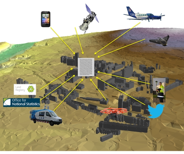
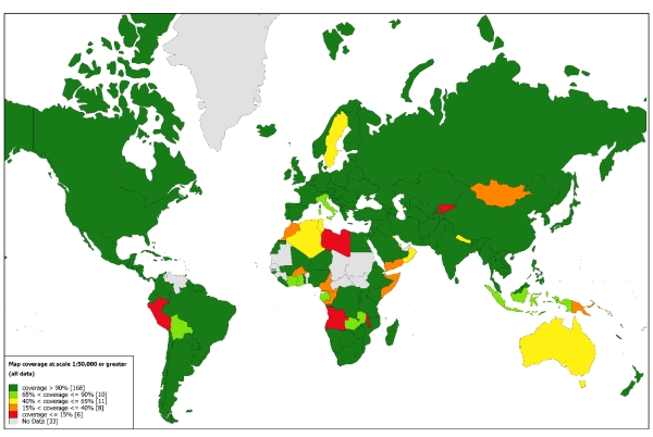
Figure 5. Current technical trends in the surveying
profession (source: Lawrence,CB, 2015) (top); global availability of
mapping at scale 1:50,000 (source: Konecny, 2015) (bottom) /p>
3.1 Technology in support of City Management
The urbanization of the world’s population also requires massive
development of public infrastructure that must be supported by
interdisciplinary projects with the involvement of various professions,
as well as all the disciplines of the surveying profession such as data
acquisition and measurement, positioning and navigation, land
administration, valuation, planning, coastal zone management and marine
cadastre, etc, as well as construction management and quantity surveying
to support municipal governments in their growth. There is an altogether
new and increased interest in geosciences today due to this huge
societal change.
To serve the rising population, technology is transforming regular
cities into smart cities. Cities will be connected and will interact
with people freely, give people the opportunity to manage basic
amenities in the most efficient manner, in an eco-friendly, and safe
manner. The term “smart” or “digital” city is used broadly and
demonstrates this need. There are several definitions for “smart city”.
The concept of a smart city is not static, there is no absolute
definition of a smart city, no end point, but rather a process, or
series of steps, by which cities become more 'livable' and resilient
and, hence, able to respond quickly to new challenges (British
Government, Department for Business, Innovation and Skills). It is a
developed urban area that creates sustainable economic development and
high quality of life by excelling in multiple key areas: economy,
mobility, environment, people, living, and government (https://www.bussinessdictionary.com/definition/smart-city).
Since much of our future personal and professional activity will be
within urban areas, rapid development and its resulting environmental
issues become very important. Much of the current urbanization activity
is in Asia. The Asian Development Bank calculates that each day, across
the Asian continent, there is a need for 20,000 new dwellings, 250 km of
new roads, and the infrastructure to deliver an additional 6 million
liters of potable water in the cities. The way Asian governments manage
urbanization is crucial to the health and the well being of billions of
people in that region but also worldwide; experience derived from Asia
is of exceptional value for all regions. It is worth mentioning that
environmental performance is directly related to the economic health of
each city. Data derived from various reports show that cities from
developed countries in Europe and North America generally outperform
those from developing countries in Asia, Latin America and Africa.
Richer cities in general are able to make necessary investments in urban
infrastructure, and can afford to maintain a professional, experienced
civil service to drive environmental initiatives (Table 1, Figure 6).
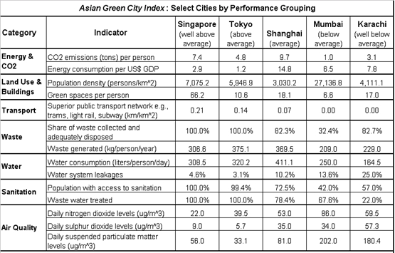
Singapore, for example, is the most green among 22 other large Asian
cities and is also the fourth richest city in the same list, with a GDP
of US$36,500 per person. It can afford cutting-edge water recycling
plants, waste-to-energy facilities and major investments in its
transport system (Economist Intelligence Unit (EIU), 2011). Cities
should develop a clear green strategy and efficient tools to quantify
and measure performances in this respect.
The eight environmental performance categories for the Asian Green
City Index include: Energy & CO2, Land Use & Buildings, Transport,
Waste, Water, Sanitation, Air Quality and Environmental Governance. Each
category is comprised of one to three indicators of environmental
performance. Table 2 shows the scores for one example city from each of
the five levels of overall results shown in Table 1.
TTable 1. Up: Asian Green City Index (source: EIU,
2011) ; Right: Green City Index for Europe and US and Canada (source:
EIU, 2009)
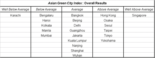
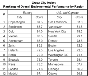
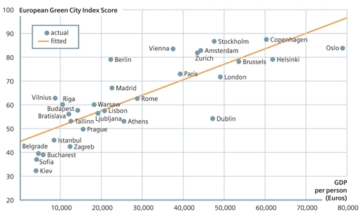
Figure 6. The link between wealth and environmental
performance (source: EIU, 2009)
Table 2. Environmental performance scores of five Asian cities (source:
EIU, 2011)
Due to such increased complexity of the megacities, professionals in
geoinformatics are expected to develop expertise and capacity building
in reliable and reusable information provision (including information
acquisition, processing, analysis, management, communication,
visualization and animation), by developing for example DSMs/DTMs, GIS,
UAV apps, mobile mapping services,3d/4d city models, smart “apps”,
Building Information Modeling, measurement standards, installation of
sensors in smart buildings and developing the Internet of Things, using
sensors in web 2.0, mobile social sensing and a series of such
applications for parking, traffic update, smart lighting, waste
management, water monitoring, energy management, as well.
With a global construction volume of US$7.2 trillion in 2010, which
is expected to raise to US$12 trillion by 2020, quantity surveyors in
particular play an important role within the construction industry
providing a number of services such as cost planning and budgetary
estimates of projects, Value engineering / Value Management, Risk
Management and calculation, Bid Documentation, Commercial Management and
Contract Administration, Dispute Resolution, Asset Capitalisation, Cost
Control / Management process, Assessing the costs of design changes /
variations, and so on. BIM is the tool to serve and enhance such
activities. The use of BIM enhances team collaboration and understanding
among various professionals as well as better information management,
reduction of errors, and may achieve up to 40% elimination of unbudgeted
change, up to 80% reduction in time taken to generate cost estimates and
may achieve a cost estimation accuracy within 3%. Other benefits of BIM
include savings of up to 10% of a contract value through clash
detections and a reduction in project time up to 7%. BIM has already
been adopted in USA on more than 70% of projects, in Europe about 46%,
in Middle East at 25%, Australia 40%, China 15% (Figure 7). There is a
great desire by governments to adopt BIM in future and there is a great
potential for future construction development in all regions, therefore
there is an increasing need for the skills of quantity surveyors (Ong,
2015).
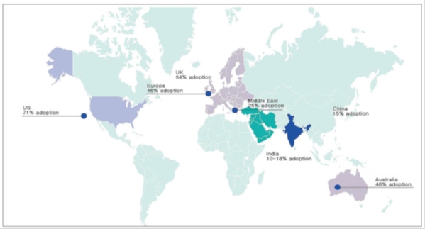
Figure 7. Status of BIM adoption globally (source: Ong, 2015)
4. CONCLUSIONS AND PROPOSALS FOR PREPARING TOMORROW’S SURVEYORS
TODAY/b>
It becomes obvious that in the urbanization and globalization era, a
globalization of science is also taking place. Surveyors should
be prepared to cooperate with several other disciplines and allied
professions; in some cases there may be severe competition from
neighboring disciplines, as well; this is a challenge surveyors need to
face through development of their own skills. Surveyors should be
prepared to deal with data inflation, to cope with large amount of
information; they should also maintain in-depth technical research,
better education, and cooperation with other professions. Through
cooperation with other professionals surveyors will increase their
skills in providing solution functionality, reliably, affordably
(fit-for-purpose processes) for a complex and rapidly changing world - a
dynamic world that cannot wait.
While in some regions there is a scarcity for surveyors, in some
other regions there maybe unemployment, too, due to the turbulent
economic situations. It is also true that there is an increased global
need for modern surveying skills and services, therefore surveyors
should continuously redefine, improve, develop and promote their
capacity and skills globally using all available means including social
media (Valani, 2015).
Professional associations and their role are changing, too; they are
challenged by a rapidly changing technology. Individual surveyors need
access to updated information about new developments in the profession
in a rapid, low-cost process. Raising awareness and capacity development
among members apart from participation to seminars, professional
capacity development programs, and conferences may also be achieved
today through new, low-cost tools, by supporting networks and
partnering, by closer cooperation with the relevant international
organizations and by supporting on-line communication among their
members. Professional associations should communicate the FIG message
that traditional tools and methods in surveying and mapping have
actually changed. Although problems remain the same due to the
technological developments there are no more single solutions to
traditional problems; there are new ways to think about those problems
and there is a new concept of privacy as well. Associations should
support the use of mobile devices, apps, the development of open
standards in all aspects and the new solutions provided by the industry
that may support sustainable systems reliably, much easier and with
significantly less costs (Jones, 2015).
Regional and national professional associations should also cooperate
closely with FIG to facilitate awareness among their members in the
global issues, to create more “global” surveyors (McLaren, 2015;
Vanderschueren, 2015), as well as to ensure arrangements in order to
facilitate cooperation among the private sector to carry out cross
boarder professional work; mutual, uniform recognition of surveyors’
qualifications within greater regions and experience sharing in this
field may help significantly (Lelliott, 2015).
It is therefore urgent for the surveying profession to be
customer-oriented, to think ahead, to predict future changes, and to
foresee the requirements of the next generation of the public and
structure the way ahead. It is within the FIG goals to develop a
prosperous and sustainable profession which will translate the post 2015
sustainable development agenda into action. There is a fast-growing
civil demand and a changing culture for authoritative spatial
information published on the web, a culture that changes the
administrative concept. The question is how much change can governments
afford? To satisfy such great demand the use of data derived from
various providers may be supportive; there is a need for increasing
capacity development in assessing the value of data derived through
crowdsourcing (Doytscher, 2015). Authoritative data can be provided
and assured by government agencies but also by crowdsourcing and the
engagement of surveyors. Today mobile devices are accessible to more
people, the cost of high resolution satellite imagery is coming down,
and there is a renewed awareness of the importance of authoritative
spatial data in all levels of government. Technology is addressing many
past challenges of system cost, intermittent internet connectivity, and
distributed service centers. Spatial platform, security cloud mapping
and app technologies can be used for collecting AAA information from
crowdsourced models (Jones, 2015). Surveyors should integrate
information derived from various venders, depending on the availability
of tools, and develop increased information processing capabilities to
deal with a dynamic world, dynamic society, dynamic markets,
dynamic information, to see change positively, and provide the
70% of the world that has not yet developed good spatial data
infrastructures, but also the other 30% of the world that needs to
further improve the efficiency of its systems in order to address the
current challenges, with surveyors’ “good, fast and cheap”, “fit-for-purpose”
services and solutions (de Zeeuw, 2015). The relation between quality
and cost has been significantly improved today by new technologies; we
need to investigate and be aware of the achievements but also of the
remaining challenges of new technologies and encourage further
improvements (Staiger, 2015).
At the FIG kick-off event we agreed on a vision. We also agreed on
the major pillars of the FIG work plan 2015-2018. FIG will continue to
provide a global forum for discussion, communication and exchange of
experiences and new professional developments between members and
individual professionals in the broad areas of surveying and mapping,
spatial information management, and the management of land, the sea and
the built environment through its work plan. This relates to FIG annual
conferences, regional conferences, the work of the ten commissions
(ACCO) within their working groups and commission seminars and the work
of the Task Forces (TFs) the FIG Networks and the Permanent Institutions
FIG Foundation will continue its excellent contribution to supporting
capacity development and research in areas most in need (Hohol, 2015).
FIG contribution to the global sustainable development agenda will
focus on three pillars: (a) providing fit-for-purpose solutions for
security of tenure land administration, (b) providing support on
property markets assessment and improvement and (c) providing technical
support in developing technical specifications on the above topics. In
this effort FIG will continue to strengthen cooperation and to build
partnerships with the relevant international organizations and regional
professional bodies.
The council will ensure that this global forum offers opportunities
for all aspects of surveying practice, its various disciplines and the
total range of its professional areas. The council will also ensure that
the performance according to the agreed work plan will be monitored and
supported by the responsible council members. The council will work
closely with the FIG family to agree upon the deliverables and upon key
performance indicators (McLaren, 2015) for monitoring the performance
during the next 4 years and will report annually.
REFERENCES
Adlington, G., 2011. The Rice or Fall of the Cadastre Empire. Proc.
of International FIG Simposium & Commission 7 Annual Meeting on
“Cadastre 2.0”, Innsbruck, Austria. pp. 21-28.
Adlington, G., 2015. Cadastral Survey in the 21st Century, and why
the 19th Century Matters. Proc. of FIG Kick-off Event on “Ensuring the
Rapid Response to Change, Ensuring the Surveyor of Tomorrow”, Athens,
Greece,
http://fig.net/news/news_2015/2015_01_kick_off_athens.htm
AAugustinus, C., 2010. Social Tenure Domain Model: What It Can Mean
for the Land Industry and the Poor. Proc. of XXIV FIG Congress, Sydney,
Australia,
http://www.fig.net/pub/fig2010/papers/inv02/inv02_augustinus
_3724.pdf
Barry, M., 2015. Challenges in implementing innovations in Land
Administration. Proc. of Annual World Bank Conference on “Land and
Poverty”, FIG side event, Washington DC, USA (to be published in the FIG
website). /p>
Bourguignon, C., Munoz, J., 2015. Fifty Years of World Bank
Engagement on Land Tenure Issues, Proc. of Annual World Bank Conference
on Land and Poverty, Washington DC,
https://www.conftool.com/landandpoverty2015/index.php?page=browseSessions&presentations=show&search=Jorge+Munoz
Cheng, P., 2015. Developing Emergency Mapping, Meeting the Surveyor
of Tomorrow. Proc. of FIG Kick-off Event on “Ensuring the Rapid Response
to Change, Ensuring the Surveyor of Tomorrow”, Athens, Greece,
http://fig.net/news/news_2015/2015_01_kick_off_athens.htm
Cisneros, H., Retsinas, N., Kemp, J., Colton, K., 2007. Our
Communities, our Homes - Pathways to Housing and Homeownership in
America’s Cities and States. Joint Center for Housing Studies of Harvard
University, ISBN 0-9761481-1-0
Dale, P., 2005. Land Administration in the UNECE region – Development
trends and main principles. United Nations edition. New York and Geneva,
p. 104.
Davis, M., 2006. Planet of Slums. Verso. London, ISBN: 9781844671601
Doytscher, Y., 2015. FIG Com 3 Publication on: The Potential of
Crowdsourcing in Geospatial Data Collection. Proc. of Annual World Bank
Conference on “Land and Poverty”, FIG side event, Washington DC, USA (to
be published in the FIG website). Economist Intelligence Unit (EIU),
2009. European Green City Index. Publisher SIEMENS AG, Munich, p. 51,
http://www.siemens.com/press/pool/de/events/corporate/2009-12-Cop15/European_Green_City_Index.pdf
Economist Intelligence Unit (EIU), 2011. Asian Green City Index.
Publisher SIEMENS AG, Munich, p. 63,
http://www.thecrystal.org/assets/download/Asian-Green-City-Index.pdf
Enemark, S., 2015. Land Administration and human rights, the role of
land professionals in support of the global agenda. Proc. of Annual
World Bank Conference on “Land and Poverty”, FIG side event, Washington
DC, USA (to be published in the FIG website).
FAO, 2012. Voluntary Guidelines on the Responsible Governance of
Tenure of Land, Fisheries and Forests in the Context of National Food
Security. FAO Publications, ISBN 978-92-5-107277-6,
http://www.fao.org/docrep/016/i2801e/i2801e.pdf
Foster, R., 2015. Looking Back, Looking Ahead. Proc. of FIG Kick-off
Event on “Ensuring the Rapid Response to Change, Ensuring the Surveyor
of Tomorrow”, Athens, Greece,
http://fig.net/news/news_2015/2015_01_kick_off_athens.htm
Haklay, M.E., Antoniou, V., Basiouka, S., Soden, R., Mooney, P, 2014.
Crowdsourced Geographic Information Use in Government. Global Facility
for Disaster Reduction & Recovery (GFDRR), World Bank: London, UK.
Hohol, J., 2015. The FIG Foundation – Building a Sustainable Future.
Activities and Accomplishments during the Past Four Years. Proc. of FIG
Kick-off Event on “Ensuring the Rapid Response to Change, Ensuring the
Surveyor of Tomorrow”, Athens, Greece,
http://fig.net/news/news_2015/2015_01_kick_off_athens.htm
Jones, B., 2015. The Changing Value of Professional Associations.
Proc. of FIG Kick-off Event on “Ensuring the Rapid Response to Change,
Ensuring the Surveyor of Tomorrow”, Athens, Greece,
http://fig.net/news/news_2015/2015_01_kick_off_athens.htm
Jorgenson, W., Ho, M.S., Samuels, J.D., 2014. Long-term Estimates of
U.S. Productivity and Growth. Proc. of World KLEMS Conference.
Keyes, R.W., 2006. The Impact of Moore's Law. Solid-State Circuits
Society Newsletter, IEEE, vol. 11(5), pp. 25-27.
Konecny, G., 2013. The International Society of Photogrammetry and
Remote Sensing Study on the Status of Mapping on the World. Proc. of
Interexpo GEO_Siberia-2013, Novosibirsk,
http://www2.isprs.org/commissions/comm4/wg2/downloads.html
Konecny, G. 2015. The Status of Topographic Mapping. Proc. of
Interexpo GEO-Siberia-2015, Novosibirsk (to be published).
Lawrence, CB V., 2015. The Importance of Surveying: Looking to the
Future. Proc. of FIG Kick-off Event on “Ensuring the Rapid Response to
Change, Ensuring the Surveyor of Tomorrow”, Athens, Greece,
http://fig.net/news/news_2015/2015_01_kick_off_athens.htm
Lelliott, M., 2015. The Private Sector and its Response to Change.
Mobility of Professionals within Europe. Proc. of FIG Kick-off Event on
“Ensuring the Rapid Response to Change, Ensuring the Surveyor of
Tomorrow”, Athens, Greece,
http://fig.net/news/news_2015/2015_01_kick_off_athens.htm
Lemmen, C., 2015. A New Era in Land Administration. Proc. of Annual
World Bank Conference on “Land and Poverty”, FIG side event, Washington
DC, USA (to be published in the FIG website).
Magel, H., 2011. Governance and Regionalization: New Paradigms for
Transparent Politics and Accountable Civic Engagement. Proc. of FIG
Working Week, Marrakech, Morocco,
http://www.fig.net/pub/fig2011/ppt/ps02/ps02_magel_5439_ppt.pdf
McLaren, R., 2015. Tomorrow’s Surveyor Today – Member Associations’
Responsibilities. Proc. of FIG Kick-off Event on “Ensuring the Rapid
Response to Change, Ensuring the Surveyor of Tomorrow”, Athens, Greece,
http://fig.net/news/news_2015/2015_01_kick_off_athens.htm
van der Molen P., 2003. The Future Cadastres – Cadastres after 2014.
Proc. of FIG Working Week 2003, Paris,
http://www.fig.net/pub/fig_2003/PS_1/PS1_3_vanderMolen.pdf
Munro-Faure, P., 2015. Global FAO Guidelines on Governance of Tenure
of Land, Fisheries and Forests. Proc. of FIG Kick-off Event on “Ensuring
the Rapid Response to Change, Ensuring the Surveyor of Tomorrow”,
Athens, Greece,
http://fig.net/news/news_2015/2015_01_kick_off_athens.htm
Nystrom, S., Potsiou, C., 2015. Quantifying the effects of Land
Policy on National Economies. Proc. of Annual World Bank Conference on
“Land and Poverty”, FIG side event, Washington DC, USA (to be published
in the FIG website).
Ong, S.L., 2012. Preserving the Built Environment: Importance of
Building Information Modeling. Proc. of FIG Working Week,
http://www.fig.net/pub/fig2012/ppt/ps03/ps03_ong_6246_ppt.pdf
Ong, S.L., 2015. Building Information Modeling (BIM) – Global
Maturity in Adopting BIM. Proc. of FIG Kick-off Event on “Ensuring the
Rapid Response to Change, Ensuring the Surveyor of Tomorrow”, Athens,
Greece,
http://fig.net/news/news_2015/2015_01_kick_off_athens.htm
Onsrud, H., Lodin, M., Jazo, S., 2015. Key factors for success in
Land Administration projects – Lessons learned from projects in South
East Europe. Proc. of Annual World Bank Conference on “Land and
Poverty”, Washington DC, USA,
https://www.conftool.com/landandpoverty2015/index.php?page=browseSessions&presentations=show&search=Onsrud
Potsiou, C., 2011. Informal Urban Development in Europe - Experiences
from Albania and Greece. United Nations Human Settlements Programme
(UN-HABITAT), ISBN: 978-92-1-132266-8,
http://www.fig.net/pub/others/un-habitat_informal_urban_dev.pdf
Potsiou, C., 2014. Ensuring the Rapid Response to Change, Ensuring
the Surveyor of Tomorrow. Proc. of FIG Commission 3 Workshop & Annual
Meeting, Bologna, Italy.
Potsiou, C., 2015. Formalizing the Informal: Challenges and
Opportunities of Informal Settlements in South-East Europe. United
Nations - FIG publication, ISBN 978-87-92853-32-5,
http://www.unece.org/fileadmin/DAM/hlm/wpla/workshops/informal_settlements_2015/
advanced_formalizing_informal.pdf
Potsiou, C., Doytscher, Y., Kelly, P., Khouri, R., McLaren, R.,
Mueller, H., 2010. Rapid Urbanization and Mega Cities: The Need for
Spatial Information Management. FIG Article of the Month – March 2010,
http://www.fig.net/pub/monthly_articles/march_2010/march_2010_potsiou_etal.html
Rauch, J., 2001. The New Old Economy: Oil, Computers, and the
Reinvention of the Earth. The Atlantic Monthly,
http://www.theatlantic.com/past/docs/issues/2001/01/rauch.htm
Retsinas, N., 2015. Opening Doors to Private Investment. Proc. of FIG
Kick-off Event on “Ensuring the Rapid Response to Change, Ensuring the
Surveyor of Tomorrow”, Athens, Greece,
http://fig.net/news/news_2015/2015_01_kick_off_athens.htm
Roberge, D., 2015. Need for a core cadastral system-Develop once and
make available for all. Proc. of Annual World Bank Conference on “Land
and Poverty”, FIG side event, Washington DC, USA (to be published in the
FIG website).
de Soto, H., 2000. The Mystery of Capital: Why Capitalism Triumphs in
the West and Fails Everywhere Else. Basic Books, ISBN 0-465-01614-6.
de Soto, H., 2014. The Capitalist Cure for Terrorism. The Wall Street
Journal,
http://www.wsj.com/articles/the-capitalist-cure-for-terrorism-1412973796
Staiger, R., 2015. ACCO-Achievements and Future Goals. Proc. of FIG
Kick-off Event on “Ensuring the Rapid Response to Change, Ensuring the
Surveyor of Tomorrow”, Athens, Greece,
http://fig.net/news/news_2015/2015_01_kick_off_athens.htm
TTeo, C. H., 2015. FIG: 2011–2014. Proc. of FIG Kick-off Event on
“Ensuring the Rapid Response to Change, Ensuring the Surveyor of
Tomorrow”, Athens, Greece,
http://fig.net/news/news_2015/2015_01_kick_off
_athens.htm
Tsencova, S., Potsiou, C., Badyina, A., 2009. Self-made cities.
United Nations publications, New York and Geneva, ISBN
978-92-1-117005-4,
http://www.unece.org/fileadmin/DAM/publications/oes/SelfMadeCities.pdf
UN-HABITAT, 2012. State of the World’s Cities 2012/2013 - Prosperity
of cities. UN-HABITAT publication, Nairobi, Kenya.
UN Open Working Group, 2014. Sustainable Development Goals. Report of
the Open Working Group of the UN General Assembly,
http://sustainabledevelopment.un.org/content/documents/1579SDGs%20Proposal.pdf&embedded=true
Valanis, A., 2015. The Experience of a Greek Young Surveyor. Proc. of
FIG Kick-off Event on “Ensuring the Rapid Response to Change, Ensuring
the Surveyor of Tomorrow”, Athens, Greece,
http://fig.net/news/news_2015/2015_01_kick_off_athens.htm
Vanderschueren, M., 2015. Technical and Political Support of FIG and
FGF (Federation of French Speaking Surveyors) for the African
Associations of Surveyors. Proc. of FIG Kick-off Event on “Ensuring the
Rapid Response to Change, Ensuring the Surveyor of Tomorrow”, Athens,
Greece,
http://fig.net/news/news_2015/2015_01_kick_off
_athens.htm
World Bank, 2013. Doing Business 2013 – Smarter regulations for small
and medium-size enterprises. ISBN 978-0-8213-9615-5,br />
http://www.doingbusiness.org/~/media/GIAWB/Doing%20Business/Documents/Annual-Reports/English/DB13-full-report.pdf
de Zeeuw, K., 2015. A New Era: Dynamic Information Management. Proc.
of FIG Kick-off Event on “Ensuring the Rapid Response to Change,
Ensuring the Surveyor of Tomorrow”, Athens, Greece,
http://fig.net/news/news_2015/2015_01_kick_off_athens.htm
|


